File:Post Medieval Asymmetrical Buckle (FindID 597012).jpg
Jump to navigation
Jump to search

Size of this preview: 745 × 600 pixels. Other resolutions: 298 × 240 pixels | 597 × 480 pixels | 954 × 768 pixels | 1,272 × 1,024 pixels | 2,203 × 1,773 pixels.
Original file (2,203 × 1,773 pixels, file size: 1.25 MB, MIME type: image/jpeg)
Captions
Captions
Add a one-line explanation of what this file represents
Summary
[edit].jpg&action=edit§ion=1)
| Post Medieval Asymmetrical Buckle | |||
|---|---|---|---|
| Photographer |
Winchester Museums Service, Ellie Vandyk, 2014-01-23 12:42:03 |
||
| Title |
Post Medieval Asymmetrical Buckle |
||
| Description |
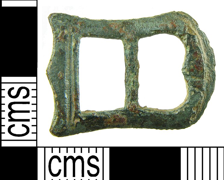
English: An incomplete Post-Medieval (1575-1700) copper alloy double-loop asymmetrical buckle frame, missing its pin. It measures 22.7x15.2mm and weighs 2.1g. The frame has one rectangular and one 'D'- shaped loop. The rectangular loop has a groove flanking the inside edge and an ornate outside edge, with a central triangle and a triangle at each corner.. At the centre of the 'D '-shaped loop the inner edge projects inwards slightly and beyond is a transverse groove for the (missing) pin. The outside curved edge is flanked by a groove. The bar is narrowed. Such buckles tend to be attributed a 17th-century date (cf. Whitehead 1996, 91; ref. 571). |
||
| Depicted place | (County of findspot) Hampshire | ||
| Date | between 1575 and 1700 | ||
| Accession number |
FindID: 597012 Old ref: HAMP-10C3B6 Filename: HAMP-10C3B6AsymmetricalBuckle.jpg |
||
| Credit line |
|
||
| Source |
https://finds.org.uk/database/ajax/download/id/453622 Catalog: https://finds.org.uk/database/images/image/id/453622/recordtype/artefacts archive copy at the Wayback Machine Artefact: https://finds.org.uk/database/artefacts/record/id/597012 |
||
| Permission (Reusing this file) |
Attribution-ShareAlike License version 4.0 (verified 24 November 2020) | ||
| Object location | | View this and other nearby images on: OpenStreetMap |
|---|
.jpg¶ms=051.023600_N_-001.303440_E_globe:Earth_class:object_type:object__&language=en)
Licensing
[edit].jpg&action=edit§ion=2)
This file is licensed under the Creative Commons Attribution-Share Alike 4.0 International license.
Attribution: The Portable Antiquities Scheme/ The Trustees of the British Museum
- You are free:
- to share – to copy, distribute and transmit the work
- to remix – to adapt the work
- Under the following conditions:
- attribution – You must give appropriate credit, provide a link to the license, and indicate if changes were made. You may do so in any reasonable manner, but not in any way that suggests the licensor endorses you or your use.
- share alike – If you remix, transform, or build upon the material, you must distribute your contributions under the same or compatible license as the original.
File history
Click on a date/time to view the file as it appeared at that time.
| Date/Time | Thumbnail | Dimensions | User | Comment | |
|---|---|---|---|---|---|
| current | 04:36, 26 January 2017 | | 2,203 × 1,773 (1.25 MB) | Fæ (talk | contribs) | Portable Antiquities Scheme, HAMP, FindID: 597012, post medieval, page 2275, batch count 4310 |
You cannot overwrite this file.
File usage on Commons
The following page uses this file:
.jpg)
.jpg&oldid=816323469)