File:Post medieval spur buckle (FindID 50355).jpg
Jump to navigation
Jump to search

Size of this preview: 715 × 600 pixels. Other resolutions: 286 × 240 pixels | 572 × 480 pixels | 915 × 768 pixels | 1,221 × 1,024 pixels | 1,466 × 1,230 pixels.
Original file (1,466 × 1,230 pixels, file size: 721 KB, MIME type: image/jpeg)
Captions
Captions
Add a one-line explanation of what this file represents
Summary
[edit].jpg&action=edit§ion=1)
| Post medieval spur buckle | |||
|---|---|---|---|
| Photographer |
Winchester Museum Service, Jodi Puls, 2003-07-25 14:54:45 |
||
| Title |
Post medieval spur buckle |
||
| Description |
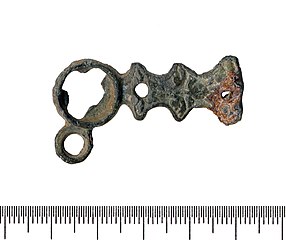
English: Cast copper alloy mount from a sword-belt consisting of a plate with attachment loop. The mount measures 41.44 x 22.75mm. Along each long edge of the plate there are two projections and the plate appears to have ended in a trefoil (W. at projections 12.95mm, W. of trefoil 16.1mm, minimum W. of plate 6.93mm). The projections and trefoil are linked by concave curved edges. At the other end of the mount is a circular lobe with a raised rim (external D. 15.3mm) and the remains of a thin sheet centre. In the centre is a roughly cruciform hole, possibly deliberately made this shape or perhaps the result of wear. On one side of this lobe is a smaller circular loop (external D. 8.75mm) There are two rivet holes in the plate, one at each end , and there is evidence of iron corrosion around the rivet hole at the trefoil end. Scrolled foliate design on the upper surface of the plate. The reverse is generally flat, although the plate is slightly hollowed. Even green patina. |
||
| Depicted place | (County of findspot) Hampshire | ||
| Date | between 1500 and 1600 | ||
| Accession number |
FindID: 50355 Old ref: HAMP-126593 Filename: Hamp 126593.JPG |
||
| Credit line |
|
||
| Source |
https://finds.org.uk/database/ajax/download/id/5989 Catalog: https://finds.org.uk/database/images/image/id/5989 Artefact: https://finds.org.uk/database/artefacts/record/id/50355 |
||
| Permission (Reusing this file) |
Attribution-ShareAlike License | ||
| Object location | | View this and other nearby images on: OpenStreetMap |
|---|
.jpg¶ms=051.157200_N_-001.257540_E_globe:Earth_class:object_type:object__&language=en)
Licensing
[edit].jpg&action=edit§ion=2)
This file is licensed under the Creative Commons Attribution-Share Alike 2.0 Generic license.
Attribution: The Portable Antiquities Scheme/ The Trustees of the British Museum
- You are free:
- to share – to copy, distribute and transmit the work
- to remix – to adapt the work
- Under the following conditions:
- attribution – You must give appropriate credit, provide a link to the license, and indicate if changes were made. You may do so in any reasonable manner, but not in any way that suggests the licensor endorses you or your use.
- share alike – If you remix, transform, or build upon the material, you must distribute your contributions under the same or compatible license as the original.
File history
Click on a date/time to view the file as it appeared at that time.
| Date/Time | Thumbnail | Dimensions | User | Comment | |
|---|---|---|---|---|---|
| current | 03:26, 30 January 2017 | | 1,466 × 1,230 (721 KB) | Fæ (talk | contribs) | Portable Antiquities Scheme, HAMP, FindID: 50355, post medieval, page 303, batch count 5126 |
You cannot overwrite this file.
File usage on Commons
The following page uses this file:
.jpg)
.jpg&oldid=544868791)