File:Prefecture of Illyricum map.png
Zur Navigation springen
Zur Suche springen

Größe dieser Vorschau: 607 × 600 Pixel. Weitere Auflösungen: 243 × 240 Pixel | 486 × 480 Pixel | 778 × 768 Pixel | 1.054 × 1.041 Pixel.
Originaldatei (1.054 × 1.041 Pixel, Dateigröße: 103 KB, MIME-Typ: image/png)
Bildtexte
Kurzbeschreibungen
Ergänze eine einzeilige Erklärung, was diese Datei darstellt.
Beschreibung
[Bearbeiten]| Beschreibung |
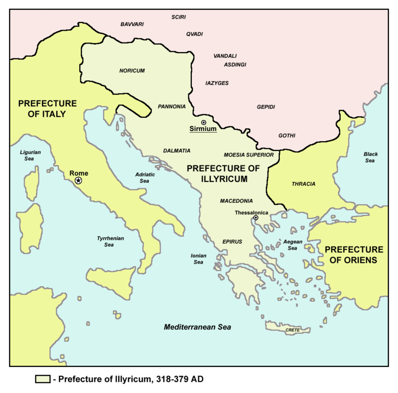
English: Historic map of Roman Praetorian Prefecture of Illyricum, 318-379 AD.
Српски / srpski: Istorijska karta rimske pretorijanske prefekture Ilirik, 318-379. godine.
Македонски: Историска карта на Римската преториска префектура Илирикум, во периодот од 318-379 година. |
| Datum | 6. Dezember 2005 (Original-Hochladedatum) |
| Quelle | Übertragen aus en.wikipedia nach Commons.: en:sr:Слика:Prefecture.png |
| Urheber | Der ursprünglich hochladende Benutzer war PANONIAN in der Wikipedia auf Englisch |
| Andere Versionen |
[]
|


Lizenz
[Bearbeiten]
self made map by user:PANONIAN
| Dieses Werk wurde von seinem Urheber PANONIAN in der Wikipedia auf Englisch als gemeinfrei veröffentlicht. Dies gilt weltweit. In manchen Staaten könnte dies rechtlich nicht möglich sein. Sofern dies der Fall ist: PANONIAN gewährt jedem das bedingungslose Recht, dieses Werk für jedweden Zweck zu nutzen, es sei denn, Bedingungen sind gesetzlich erforderlich. |
References
[Bearbeiten]
- The Times History of Europe, Times Books, London, 2002.
- Dragan Brujić, Vodič kroz Svet antike, Beograd, 2005.
- Dragan Brujić, Vodič kroz Svet Vizantije, Beograd, 2004.
- Petar Milošević, Arheologija i istorija Sirmijuma, Novi Sad, 2001.
- http://sitemaker.umich.edu/mladjov/files/romanprefectures395s.jpg
- http://www.roman-empire.net/maps/empire/extent/constantine.html
- http://www.newadvent.org/cathen/07663a.htm
Ursprüngliches Datei-Logbuch
[Bearbeiten]
Die ursprüngliche Dateibeschreibungsseite war hier. Alle folgenden Benutzernamen beziehen sich auf en.wikipedia.
- 2008-01-03 12:02 Megistias 1054×1041×8 (464015 bytes) historic map (self made) {{PD-self}} [[Category:Maps of the history of the Balkans]] [[Category:Maps of the history of Vojvodina]] [[Category:Maps of the history of Serbia]] [[sr:Слика:Prefecture.png]]
- 2005-12-06 03:14 PANONIAN 1054×1041×8 (464862 bytes)
Dateiversionen
Klicke auf einen Zeitpunkt, um diese Version zu laden.
| Version vom | Vorschaubild | Maße | Benutzer | Kommentar | |
|---|---|---|---|---|---|
| aktuell | 08:23, 17. Jul. 2013 | | 1.054 × 1.041 (103 KB) | PANONIAN (Diskussion | Beiträge) | aesthetics |
| 15:15, 2. Jan. 2010 |  | 1.054 × 1.041 (138 KB) | PANONIAN (Diskussion | Beiträge) | Reverted to version as of 15:07, 2 January 2010 - fixing thumbnail problem | |
| 15:13, 2. Jan. 2010 |  | 1.054 × 1.041 (138 KB) | PANONIAN (Diskussion | Beiträge) | Reverted to version as of 20:04, 1 March 2009 - fixing thumbnail problem | |
| 15:07, 2. Jan. 2010 |  | 1.054 × 1.041 (138 KB) | PANONIAN (Diskussion | Beiträge) | Thessalonica in fact was not capital before 379, so there should be no line indicating it as a capital | |
| 20:04, 1. Mär. 2009 |  | 1.054 × 1.041 (138 KB) | PANONIAN (Diskussion | Beiträge) | ||
| 15:39, 29. Apr. 2008 |  | 1.054 × 1.041 (453 KB) | Bibikoff (Diskussion | Beiträge) | {{Information |Description={{en|historic map (self made) en:Category:Maps of the history of the Balkans en:Category:Maps of the history of Vojvodina en:Category:Maps of the history of Serbia en:sr:Слика:Prefecture.png}} |Source= |
Du kannst diese Datei nicht überschreiben.
Dateiverwendung
Die folgenden 13 Seiten verwenden diese Datei:
- Atlas of Albania
- Atlas of Bosnia and Herzegovina
- Atlas of Kosovo
- Atlas of Republika Srpska
- Atlas of Serbia
- Atlas of Vojvodina
- Illyria and Illyrians
- File:Prefecture.png (Dateiweiterleitung)
- File:PrefectureIllyricum.png
- File:Prefecture of Illyricum map-sr.png
- File:Prefecture of Illyricum map-zh.png
- File:Prefecture of Illyricum map.png
- Template:Other versions/Prefecture of Illyricum map
Globale Dateiverwendung
Die nachfolgenden anderen Wikis verwenden diese Datei:
- Verwendung auf an.wikipedia.org
- Verwendung auf ar.wikipedia.org
- Verwendung auf be.wikipedia.org
- Verwendung auf bg.wikipedia.org
- Verwendung auf de.wikipedia.org
- Verwendung auf en.wikipedia.org
- Verwendung auf et.wikipedia.org
- Verwendung auf fa.wikipedia.org
- Verwendung auf fr.wikipedia.org
- Verwendung auf hr.wikipedia.org
- Verwendung auf id.wikipedia.org
- Verwendung auf it.wikipedia.org
- Verwendung auf ja.wikipedia.org
- Verwendung auf la.wikipedia.org
- Verwendung auf mk.wikipedia.org
- Verwendung auf nn.wikipedia.org
- Verwendung auf no.wikipedia.org
- Verwendung auf pl.wikipedia.org
- Verwendung auf pt.wikipedia.org
- Verwendung auf ro.wikipedia.org
- Verwendung auf ru.wikipedia.org
- Verwendung auf sh.wikipedia.org
- Verwendung auf sl.wikipedia.org
- Verwendung auf sq.wikipedia.org
- Verwendung auf tr.wikipedia.org
- Verwendung auf uk.wikipedia.org
Kategorien:
- Praetorian prefecture of Illyricum
- Maps of the history of the ancient Balkans
- Maps of Roman provinces
- Maps of 4th-century Europe
- Maps of the history of Vojvodina
- Maps of the history of Serbia in ancient times
- Maps of the history of Syrmia
- Maps of the history of Bosnia and Herzegovina in ancient times
- Maps of Illyricum
- Serbia in the 4th century
- Romania in the 4th century
- Maps of the history of Romania in ancient times