File:Premongol.png
跳至導覽
跳至搜尋
無更高解析度可提供。
Premongol.png (752 × 590 像素,檔案大小:31 KB,MIME 類型:image/png)
說明
說明
添加單行說明來描述出檔案所代表的內容
摘要
[編輯]

|
This map has been uploaded by Electionworld from en.wikipedia.org to enable the |
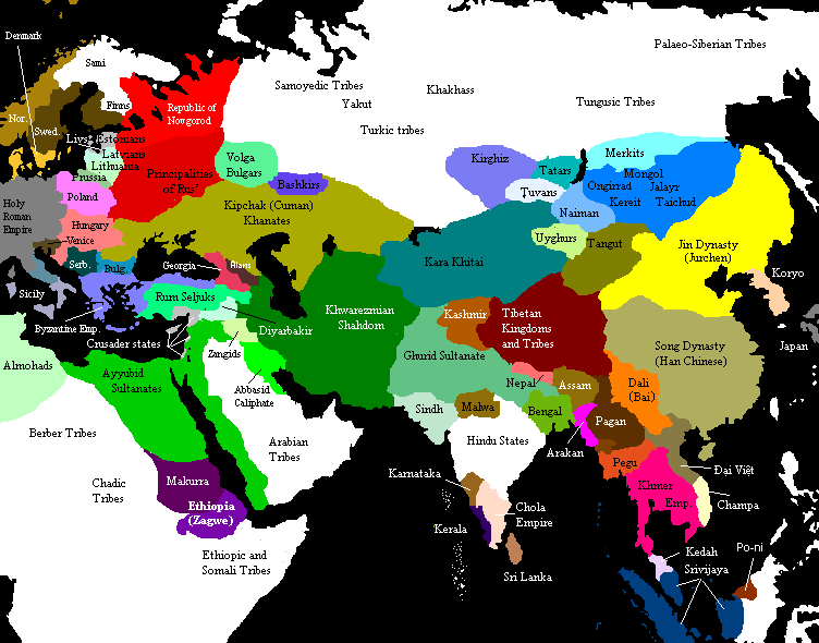
Eurasia on the eve of the Mongol invasions, c. 1200 CE. Source unknown. All of Central, North and East Asian states and tribes were located in wrong places.

|
本圖片是以PNG、GIF或JPEG格式上傳。然而,其中包含的資料或訊息,應該重新建立成可縮放向量圖形(SVG)檔案,以更有效率或更準確的方式儲存。如有可能,請上傳本圖片的SVG格式版本。在上傳之後,請修改維基各姊妹計畫中所有使用舊版圖片的條目(列在圖像連結章節中),替換為新版圖片,並在舊圖片的描述頁中加入{{Vector version available|新圖片名稱.svg}}模板,同時移除本模板。
|
授權條款
[編輯]

|
已授權您依據自由軟體基金會發行的無固定段落、封面文字和封底文字GNU自由文件授權條款1.2版或任意後續版本,對本檔進行複製、傳播和/或修改。該協議的副本列在GNU自由文件授權條款中。 |
| 此檔案採用共享創意 姓名標示-相同方式分享 3.0 未在地化版本授權條款。 | ||
| ||
| 已新增授權條款標題至此檔案,作為GFDL授權更新的一部份。 |
See also
[編輯]

Original upload notes
[編輯]
20:43, 21 November 2006 . . Timmie.merc (talk | contribs | block) 752 × 590 (31,383 bytes) (Reverted to earlier revision)
20:42, 21 November 2006 . . Timmie.merc (talk | contribs | block) 752 × 590 (31,383 bytes) (Reverted to earlier revision)
17:31, 3 October 2006 . . Vilniškis (talk | contribs | block) 752 × 590 (31,383 bytes) (Eurasia on the eve of the Mongol invasions, c. 1200.)
17:26, 3 October 2006 . . Vilniškis (talk | contribs | block) 752 × 590 (31,383 bytes)
18:11, 26 September 2006 . . Nanshu (talk | contribs | block) 752 × 590 (20,501 bytes) (minor corrections on East Asia)
20:35, 6 June 2006 . . Foobaz (talk | contribs | block) 752 × 590 (20,505 bytes) (Changed name of Vietnam from Annam to Đại Việt as talk page suggested.)
12:26, 1 June 2006 . . Foobaz (talk | contribs | block) 752 × 590 (20,469 bytes) (fixed spelling error in Africa: "Berber Trubes" -> "Berber Tribes")
00:26, 14 January 2006 . . Briangotts (talk | contribs | block) 752 × 590 (45,292 bytes) (Eurasia on the eve of the Mongol invasions, c. 1200 CE. Category:Historical maps by User:Briangotts)
10:42, 22 December 2005 . . Briangotts (talk | contribs | block) 752 × 590 (44,927 bytes) (Eurasia on the eve of the Mongol invasions, c. 1200 CE. Category:Historical maps by User:Briangotts)
| 註解 | 該圖片含有註解:在維基媒體共享資源上查看註解 |
檔案歷史
點選日期/時間以檢視該時間的檔案版本。
| 日期/時間 | 縮圖 | 尺寸 | 用戶 | 備註 | |
|---|---|---|---|---|---|
| 目前 | 2019年9月29日 (日) 13:27 | | 752 × 590(31 KB) | Бмхүн(對話 | 貢獻) | incorrect{{DEFAULTSORT:<noinclude></noinclude>}} |
| 2018年11月22日 (四) 19:04 |  | 752 × 590(31 KB) | Spiridon Ion Cepleanu(對話 | 貢獻) | Reverted to version as of 19:35, 27 March 2014 (UTC) | |
| 2015年3月8日 (日) 20:59 |  | 3,240 × 1,903(6.82 MB) | Spiridon Ion Cepleanu(對話 | 貢獻) | Modification after discussion with Khorichar and verifications in the Westermann Grosser Atlas zur Weltgeschichte (H.E.Stier, dir.), 1985. Perhaps new ameliorations may be tried. | |
| 2015年3月3日 (二) 14:49 |  | 752 × 590(24 KB) | Spiridon Ion Cepleanu(對話 | 貢獻) | New precisions according with Khorichar's rectifications [https://commons.wikimedia.org/wiki/User_talk:Khorichar] | |
| 2014年12月11日 (四) 17:40 |  | 752 × 590(24 KB) | Spiridon Ion Cepleanu(對話 | 貢獻) | Some little details according with H.E.Stier (dir.) « Grosser Atlas zur Weltgeschichte », Westermann 1985, ISBN 3-14-100919-8, « Putzger historischer Weltatlas Cornelsen » 1990, ISBN 3-464-00176-8 & some other works. | |
| 2014年3月27日 (四) 19:35 |  | 752 × 590(31 KB) | Comnenus(對話 | 貢獻) | Reverted to version as of 06:43, 5 March 2012 | |
| 2012年8月4日 (六) 11:44 |  | 752 × 590(31 KB) | محک(對話 | 貢獻) | Tabaristan was Fals. | |
| 2012年3月5日 (一) 06:43 |  | 752 × 590(31 KB) | Ecthelion83(對話 | 貢獻) | 1. Added more geographical accuracy to Korean Peninsula 2. Cleaned up some of the artifacts from previous edits (i.e. spots of wrong color) 3. This map is meant to depict the Old World prior to the rise of the Mongol Empire, i.e. before the year 1190, ... | |
| 2012年3月5日 (一) 06:43 |  | 752 × 590(137 KB) | Ecthelion83(對話 | 貢獻) | 1. Added more geographical accuracy to Korean Peninsula 2. Cleaned up some of the artifacts from previous edits (i.e. spots of wrong color) 3. This map is meant to depict the Old World prior to the rise of the Mongol Empire, i.e. before the year 1190, ... | |
| 2011年9月21日 (三) 14:44 |  | 752 × 590(137 KB) | Comnenus(對話 | 貢獻) | Reverted to version as of 18:29, 20 August 2011 Venice did not rule those territories in 1200. |
無法覆蓋此檔案。
檔案用途
下列3個頁面有用到此檔案:
全域檔案使用狀況
以下其他 wiki 使用了這個檔案:
- ar.wikipedia.org 的使用狀況
- azb.wikipedia.org 的使用狀況
- ca.wikipedia.org 的使用狀況
- de.wikipedia.org 的使用狀況
- de.wikiversity.org 的使用狀況
- en.wikipedia.org 的使用狀況
- en.wikibooks.org 的使用狀況
- es.wikipedia.org 的使用狀況
- et.wikipedia.org 的使用狀況
- fa.wikipedia.org 的使用狀況
- fr.wikipedia.org 的使用狀況
- hi.wikipedia.org 的使用狀況
- it.wikipedia.org 的使用狀況
- mn.wikipedia.org 的使用狀況
- pnb.wikipedia.org 的使用狀況
- ru.wikipedia.org 的使用狀況
- ta.wikipedia.org 的使用狀況
- tl.wikipedia.org 的使用狀況
- www.wikidata.org 的使用狀況