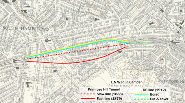
File:Primrose Hill tunnels diagram.png
Jump to navigation
Jump to search

Size of this preview: 800 × 448 pixels. Other resolutions: 320 × 179 pixels | 640 × 358 pixels | 1,024 × 573 pixels | 1,581 × 885 pixels.
Original file (1,581 × 885 pixels, file size: 2.78 MB, MIME type: image/png)
Captions
Captions
Add a one-line explanation of what this file represents
Summary[edit]
| Description | ||||
| Date |
(Ordnance Survey) [Annotations 2021] |
|||
| Source | Own work (annotation) / Ordnance Survey | |||
| Author | Rcsprinter123 | |||
| Permission (Reusing this file) |
|

File history
Click on a date/time to view the file as it appeared at that time.
| Date/Time | Thumbnail | Dimensions | User | Comment | |
|---|---|---|---|---|---|
| current | 15:51, 13 January 2021 | | 1,581 × 885 (2.78 MB) | Rcsprinter123 (talk | contribs) | . |
| 15:44, 13 January 2021 |  | 1,581 × 885 (2.72 MB) | Rcsprinter123 (talk | contribs) | Uploaded own work with UploadWizard |
You cannot overwrite this file.
File usage on Commons
The following 4 pages use this file:
File usage on other wikis
The following other wikis use this file:
- Usage on en.wikipedia.org
- Usage on www.wikidata.org