File:Provinces of France.png
Ir a la navegación
Ir a la búsqueda
Tamaño de esta previsualización: 596 × 599 píxeles. Otras resoluciones: 239 × 240 píxeles | 477 × 480 píxeles | 894 × 899 píxeles.
Archivo original (894 × 899 píxeles; tamaño de archivo: 39 kB; tipo MIME: image/png)
Leyendas
Leyendas
Añade una explicación corta acerca de lo que representa este archivo

|
File:Provinces of France (numered-monochrome).svg es una versión vectorial de este archivo. Debería usarse esa versión en lugar de este archivo PNG, cuando sea mejor.
File:Provinces of France.png → File:Provinces of France (numered-monochrome).svg
Para más información, lee Ayuda:SVG. |
.svg) |
Resumen[editar]
Español: Provincias de Francia
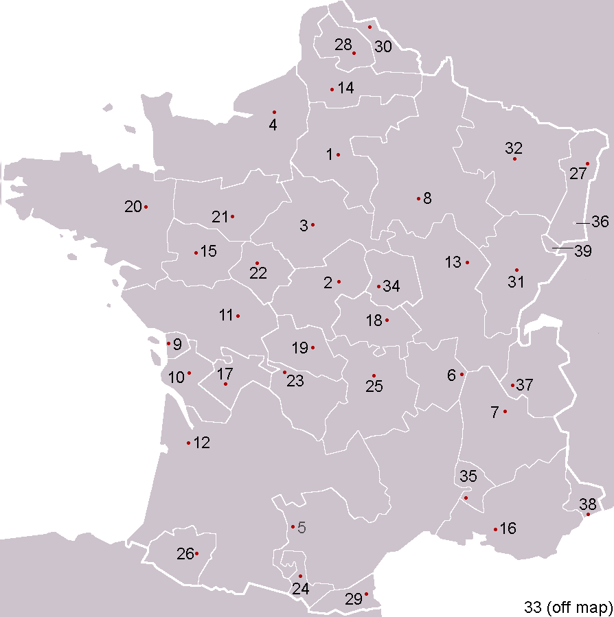
Pre-Republican provinces of France, numbered according to union with France, with provincial capitals marked.
Created by reference to a 1952 Nouveau Petit Larousse by User:OwenBlacker and licenced under the GFDL.
Provinces as follows, in the format English name (French name, Year of union; Capital):
- Royal Domain (Île-de-France, 987, Paris)
- Berry (Berry, 1101, Bourges)
- Duchy of Orléanais (Orléanais, 1198, Orléans)
- Normandy (Normandie, 1204, Rouen)
- Languedoc, mainly the County of Toulouse (Languedoc, 1270, Toulouse)
- Lyonnais (Lyonnais, 1313, Lyon)
- Dauphiné, (Dauphiné, 1349, Grenoble)
- County of Champagne (Champagne, 1361, Troyes)
- Aunis, a fief of Aquitaine (Aunis, 1371, La Rochelle)
- Saintonge (Saintonge, 1371, Saintes)
- Poitou (Poitou, 1416, Poitiers)
- Duchy of Aquitaine (Aquitaine, 1453, Bordeaux), taken from England and split into provinces of Gascogne (Armagnac) and Guyenne (Bordeaux), but excluding the viscounties of Foix, Béarn, Bigorre and Périgord (kept by Navarre)
- Duchy of Burgundy (Bourgogne, 1477, Dijon)
- Picardy (Picardie, 1482, Amiens)
- Anjou (Anjou, 1482, Angers)
- County of Provence (Provence, 1482, Aix-en-Provence)
- County of Angoulême (Angoumois, 1515, Angoulême)
- Duchy of Bourbon (Bourbonnais, 1527, Moulins)
- La Marche (Marche, 1527, Guéret)
- Duchy of Britanny (Bretagne, 1532, Rennes)
- County of Maine (Maine, 1584, Le Mans) and County of Perche (Perche, 1525, Nogent-le-Rotrou)
- Touraine (Touraine, 1584, Tours)
- Limousin (Limousin, 1589, Limoges), excluding Viscounty of Périgord (kept by Navarre)
- County of Foix (Comté de Foix, 1607, Foix) and Viscounty of Périgord (Périgord, 1607, Périgueux, attached to province of Guyenne), both former fiefs from Navarre
- Duchy of Auvergne (Auvergne, 1610, Clermont-Ferrand)
- Viscounty of Béarn (Béarn, 1620, Pau)
- Alsace (Alsace, 1648, Strasbourg)
- County of Artois, a fief of the w:Habsburgs' Spanish Netherlands (Artois, 1659, Arras)
- Roussillon (Roussillon, 1659, Perpignan)
- Flanders, a fief of the w:Habsburgs' Spanish Netherlands (Flandre, 1668, Lille)
- Free County of Burgundy (Franche-Comté, 1678, Besançon)
- Duchy of Lorraine, a personal territory of Stanisław I of Poland within the Holy Roman Empire (Lorraine, 1766, Nancy)
- Corsica (off map, Corse, 1768, Ajaccio)
The following were not provinces of France before the Revolution, but joined or were annexed to France after it, when departments had replaced all former provinces: - Duchy of Nivernais (Nivernais, 1789, Nevers)
- Comtat Venaissin, a Papal fief (Comtat Venaissain, 1791, Avignon)
- Imperial Free City of Mulhouse (Mulhouse, 1798)
- Duchy of Savoy, a state of the Kingdom of Sardinia-Piedmont (Savoie, 1860, Chambéry)
- County of Nice, a state of the Kingdom of Sardinia-Piedmont (Comté de Nice, 1860, Nice)
- Principality of Montbéliard (Montbéliard, 1816, Montbéliard)
- Free cities of Menton and Roquebrune (1861), joining France after the separation (under the protectorate of Sardinia) in 1848 from Monaco

|
Se autoriza la copia, distribución y modificación de este documento bajo los términos de la licencia de documentación libre GNU, versión 1.2 o cualquier otra que posteriormente publique la Fundación para el Software Libre; sin secciones invariables, textos de portada, ni textos de contraportada. Se incluye una copia de la dicha licencia en la sección titulada Licencia de Documentación Libre GNU. |
| Este archivo se encuentra bajo la licencia Creative Commons Genérica de Atribución/Compartir-Igual 3.0. | ||
| ||
| Esta etiqueta de licencia fue agregada a este archivo como parte de la actualización de la licencia GFDL. |
derivative works[editar]
Obras derivadas de ésta: Forteresses marches de Bretagne.png
Historial del archivo
Haz clic sobre una fecha y hora para ver el archivo tal como apareció en ese momento.
| Fecha y hora | Miniatura | Dimensiones | Usuario | Comentario | |
|---|---|---|---|---|---|
| actual | 00:53 5 feb 2005 | | 894 × 899 (39 kB) | OwenBlacker (discusión | contribs.) | Corrected map |
| 23:59 4 feb 2005 |  | 894 × 899 (39 kB) | OwenBlacker (discusión | contribs.) | Corrected map | |
| 20:24 4 feb 2005 |  | 894 × 899 (39 kB) | OwenBlacker (discusión | contribs.) | Pre-Republican provinces of France |
No puedes sobrescribir este archivo.
Usos del archivo
Las siguientes páginas usan este archivo:
Uso global del archivo
Las wikis siguientes utilizan este archivo:
- Uso en an.wikipedia.org
- Uso en ar.wikipedia.org
- كورسيكا
- لورين (منطقة)
- لانغيدوك
- بروفنس
- غشكونية
- بيكاردي
- ألزس
- إيل دو فرانس
- ليموزان
- أوني
- إفرنش كمته
- منطقة سافوا
- دوفيني
- روسيون (مقاطعة)
- قالب:مقاطعات فرنسية سابقة
- بيرش
- برطانية (فرنسا)
- أنجو
- بواتو
- مين (مقاطعة)
- بونيفاسيو
- شامبانيا (مقاطعة)
- دوقية نرمندية
- دول (فرنسا)
- بروفين
- تيل (فرنسا)
- آجدي
- روآن
- فوجير
- مورلي (فرنسا)
- بوتو (فرنسا)
- آركاشون
- جينيفيلييه
- بريانسون
- كاستيلان
- بيساك
- بنطيز
- أوري (فرنسا)
- كاربينتراس
- درو (فرنسا)
- ألتكيرش
- آنجليه
- أرجينتان
- أوبيناس
- إبلافية
- بريودي
- كابورج
- قشتال
- فورباخ
Ver más uso global de este archivo.