File:Public transport map of Rio de Janeiro.png
出自Wikimedia Commons
跳至導覽
跳至搜尋

預覽大小:800 × 547 像素。 其他解析度:320 × 219 像素 | 640 × 437 像素 | 1,024 × 700 像素 | 1,280 × 874 像素 | 2,560 × 1,749 像素 | 8,777 × 5,996 像素。
原始檔案 (8,777 × 5,996 像素,檔案大小:15.03 MB,MIME 類型:image/png)
檔案資訊
結構化資料
說明
說明
添加單行說明來描述出檔案所代表的內容

|
本圖片是以PNG、GIF或JPEG格式上傳。然而,其中包含的資料或訊息,應該重新建立成可縮放向量圖形(SVG)檔案,以更有效率或更準確的方式儲存。如有可能,請上傳本圖片的SVG格式版本。在上傳之後,請修改維基各姊妹計畫中所有使用舊版圖片的條目(列在圖像連結章節中),替換為新版圖片,並在舊圖片的描述頁中加入{{Vector version available|新圖片名稱.svg}}模板,同時移除本模板。
|
摘要
[編輯]| 描寫文Public transport map of Rio de Janeiro.png |
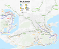
Deutsch: Karte ÖPNV Rio de Janeiro
English: Public transport map of Rio de Janeiro
Français : Plan des Transports publics de Rio de Janeiro
Português: Mapa do transporte publico do Rio de Janeiro
Need Assistance! I don't live in Brazil, but I want to make the map as accurate as possible. Informations given in medias and the Web about public transport systems are often incorrect or very inaccurate. So if you want the network map as accurate as possible too, please announce your error hints and corrections about the correct network configuration on my German discussion page. Thank you in advance! |
|||
| 日期 | see file history | |||
| 來源 | 自己的作品, using OpenStreetMap data for the background | |||
| 創作作者 | ||||
| 授權許可 (重用此檔案) |
All OpenStreetMap data and maps are Creative Commons "CC-BY-SA 2.0" licensed 此檔案採用共享創意 姓名標示-相同方式分享 2.0 通用版授權條款。
|
|||
| 地理參考 | 地理參考Wikimaps Warper中的地圖 如果不合適,請設定「warp_status = skip」為隱藏。 | |||
| 其他版本 |
|
檔案歷史
點選日期/時間以檢視該時間的檔案版本。
| 日期/時間 | 縮圖 | 尺寸 | 用戶 | 備註 | |
|---|---|---|---|---|---|
| 目前 | 2018年11月23日 (五) 21:13 |  | 8,777 × 5,996(15.03 MB) | Chumwa(對話 | 貢獻) | update, more info |
| 2018年1月24日 (三) 06:08 |  | 8,777 × 5,996(15.03 MB) | Chumwa(對話 | 貢獻) | ||
| 2017年1月12日 (四) 19:11 |  | 8,777 × 5,996(15.03 MB) | Chumwa(對話 | 貢獻) | ||
| 2016年9月13日 (二) 04:29 |  | 8,777 × 5,996(15.02 MB) | Chumwa(對話 | 貢獻) | ||
| 2016年8月5日 (五) 18:28 |  | 8,777 × 5,996(15.02 MB) | Chumwa(對話 | 貢獻) | ||
| 2016年7月17日 (日) 07:46 |  | 8,777 × 5,996(15.04 MB) | Chumwa(對話 | 貢獻) | ||
| 2016年7月2日 (六) 18:52 |  | 8,777 × 5,996(14.98 MB) | Chumwa(對話 | 貢獻) | ||
| 2016年6月26日 (日) 20:41 |  | 8,777 × 5,996(14.98 MB) | Chumwa(對話 | 貢獻) | ||
| 2016年6月20日 (一) 20:25 |  | 7,201 × 5,996(12.34 MB) | Chumwa(對話 | 貢獻) | ||
| 2016年6月19日 (日) 20:42 |  | 7,201 × 5,996(12.34 MB) | Chumwa(對話 | 貢獻) |
無法覆蓋此檔案。
檔案用途
下列46個頁面有用到此檔案:
- Metrô do Rio de Janeiro
- Top 200 transport map images that should use vector graphics
- Transit maps
- User:Chumwa/Gallery
- User:Chumwa/OgreBot/Potential transport maps/2016 August 1-10
- User:Chumwa/OgreBot/Potential transport maps/2016 July 1-10
- User:Chumwa/OgreBot/Potential transport maps/2016 July 11-20
- User:Chumwa/OgreBot/Potential transport maps/2016 June 11-20
- User:Chumwa/OgreBot/Potential transport maps/2016 June 21-30
- User:Chumwa/OgreBot/Potential transport maps/2016 September 11-20
- User:Chumwa/OgreBot/Potential transport maps/2017 January 11-20
- User:Chumwa/OgreBot/Potential transport maps/2018 January 21-31
- User:Chumwa/OgreBot/Potential transport maps/2018 November 21-30
- User:Chumwa/OgreBot/Public transport information/2016 August 1-10
- User:Chumwa/OgreBot/Public transport information/2016 July 1-10
- User:Chumwa/OgreBot/Public transport information/2016 July 11-20
- User:Chumwa/OgreBot/Public transport information/2016 June 11-20
- User:Chumwa/OgreBot/Public transport information/2016 June 21-30
- User:Chumwa/OgreBot/Public transport information/2016 September 11-20
- User:Chumwa/OgreBot/Public transport information/2017 January 11-20
- User:Chumwa/OgreBot/Public transport information/2018 January 21-31
- User:Chumwa/OgreBot/Public transport information/2018 November 21-30
- User:Chumwa/OgreBot/Transport Maps/2016 August 1-10
- User:Chumwa/OgreBot/Transport Maps/2016 July 1-10
- User:Chumwa/OgreBot/Transport Maps/2016 July 11-20
- User:Chumwa/OgreBot/Transport Maps/2016 June 11-20
- User:Chumwa/OgreBot/Transport Maps/2016 June 21-30
- User:Chumwa/OgreBot/Transport Maps/2016 September 11-20
- User:Chumwa/OgreBot/Transport Maps/2017 January 11-20
- User:Chumwa/OgreBot/Transport Maps/2018 January 21-31
- User:Chumwa/OgreBot/Transport Maps/2018 November 21-30
- User:Chumwa/OgreBot/Travel and communication maps/2016 August 1-10
- User:Chumwa/OgreBot/Travel and communication maps/2016 July 1-10
- User:Chumwa/OgreBot/Travel and communication maps/2016 July 11-20
- User:Chumwa/OgreBot/Travel and communication maps/2016 June 11-20
- User:Chumwa/OgreBot/Travel and communication maps/2016 June 21-30
- User:Chumwa/OgreBot/Travel and communication maps/2016 September 11-20
- User:Chumwa/OgreBot/Travel and communication maps/2017 January 11-20
- User:Chumwa/OgreBot/Travel and communication maps/2018 January 21-31
- User:Chumwa/OgreBot/Travel and communication maps/2018 November 21-30
- Commons:Graphic Lab/Map workshop
- File:BRT map of Barra da Tijuca.png
- File:Map of the VLT Carioca - Rio de Janeiro Light Rail.png
- File:Public transport map of Rio de Janeiro.png
- Category:Rio de Janeiro Metro
- Category:Rio de Janeiro Metro stations
全域檔案使用狀況
以下其他 wiki 使用了這個檔案:
- ar.wikipedia.org 的使用狀況
- ba.wikipedia.org 的使用狀況
- be-tarask.wikipedia.org 的使用狀況
- bg.wikipedia.org 的使用狀況
- bn.wikipedia.org 的使用狀況
- bn.wikivoyage.org 的使用狀況
- bs.wikipedia.org 的使用狀況
- da.wikipedia.org 的使用狀況
- de.wikipedia.org 的使用狀況
- en.wikipedia.org 的使用狀況
- en.wikivoyage.org 的使用狀況
- eo.wikipedia.org 的使用狀況
- es.wikipedia.org 的使用狀況
- es.wikivoyage.org 的使用狀況
- eu.wikipedia.org 的使用狀況
- fa.wikipedia.org 的使用狀況
- fi.wikipedia.org 的使用狀況
- fr.wikipedia.org 的使用狀況
- fr.wikivoyage.org 的使用狀況
- he.wikipedia.org 的使用狀況
- he.wikivoyage.org 的使用狀況
- hu.wikipedia.org 的使用狀況
- hy.wikipedia.org 的使用狀況
- hyw.wikipedia.org 的使用狀況
- id.wikipedia.org 的使用狀況
- it.wikipedia.org 的使用狀況
- it.wikivoyage.org 的使用狀況
- ja.wikipedia.org 的使用狀況
- ka.wikipedia.org 的使用狀況
- nl.wikipedia.org 的使用狀況
檢視此檔案的更多全域使用狀況。
詮釋資料
此檔案中包含其他資訊,這些資訊可能是由數位相機或掃描器在建立或數位化過程中所新增的。若檔案自原始狀態已被修改,一些詳細資料可能無法完整反映出已修改的檔案。
| 水平解析度 | 28.35 dpc |
|---|---|
| 垂直解析度 | 28.35 dpc |

