File:Qingdao, China ESA349719.jpg

Original file (2,000 × 1,542 pixels, file size: 4.39 MB, MIME type: image/jpeg)
Captions
Captions
Summary[edit]
| Description |
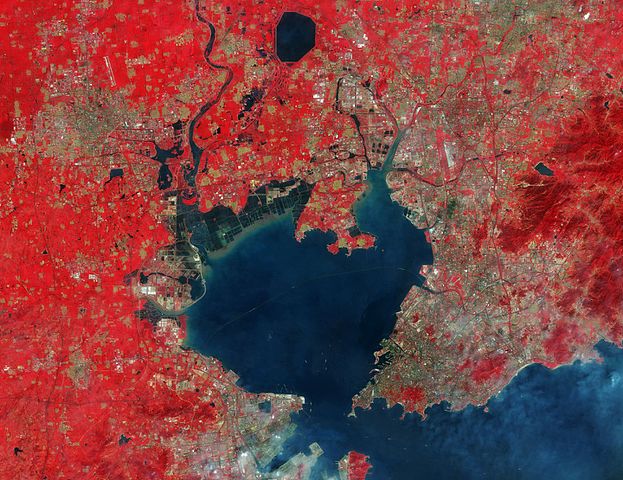
English: This impressive false-colour image features the city of Qingdao and its surroundings, in China’s eastern Shandong province.
A major cultural centre, Qingdao is home to the Ocean University of China and other higher education facilities. It is also one of China’s main hubs for marine science and technology. Qingdao sits on the south coast of the Shandong Peninsula, at the eastern entrance to Jiaozhou Bay. Off the Yellow Sea, it is one of the best natural harbours in China. Owing to the satellite’s multispectral high-resolution instrument, we can clearly make out boats entering and exiting the bay, along with the impressive 42 km-long Jiaozhou Bay Bridge running across the entire bay. As of 2012, Guinness World Records lists the bridge as the world’s longest bridge over water. Various aquacultures are visible along the coast of the bay, including the farming of fish, crustaceans, molluscs and aquatic plants. Towards the top of the image, we can make out a big body of water, the Jihongtan Reservoir, the biggest of the various reservoirs featured. The Dagu River is also visible, snaking its way from the image top down into the bay. Owing to the image processing, vegetation appears in reds scattered throughout the entire scene, showing how fertile and lush the region is. Sentinel-2A has been in orbit since 23 June. It is a polar-orbiting, multispectral high-resolution imaging satellite for land monitoring, covering vegetation, soil and water cover, inland waterways and coastal areas. Captured by Sentinel-2A on 21 August, this image is also featured on theEarth from Space video programme. |
| Date | |
| Source | http://www.esa.int/spaceinimages/Images/2015/11/Qingdao_China |
| Author | European Space Agency |
| Permission (Reusing this file) |
Copernicus Sentinel data (2015)/ESA,CC BY-SA 3.0 IGO |
| Other versions |
|
| Title | Qingdao, China |
| Set | Earth observation image of the week |
| System | Copernicus |
| Mission | Sentinel-2 |
| Location | China |
| Activity | Observing the Earth |
| Keywords | City; Satellite image |

Licensing[edit]
- You are free:
- to share – to copy, distribute and transmit the work
- to remix – to adapt the work
- Under the following conditions:
- attribution – You must give appropriate credit, provide a link to the license, and indicate if changes were made. You may do so in any reasonable manner, but not in any way that suggests the licensor endorses you or your use.
- share alike – If you remix, transform, or build upon the material, you must distribute your contributions under the same or compatible license as the original.

|
This image contains data from a satellite in the Copernicus Programme, such as Sentinel-1, Sentinel-2 or Sentinel-3. Attribution is required when using this image.
Attribution: Contains modified Copernicus Sentinel data {{{year}}}
The use of Copernicus Sentinel Data is regulated under EU law (Commission Delegated Regulation (EU) No 1159/2013 and Regulation (EU) No 377/2014). Relevant excerpts:
Free access shall be given to GMES dedicated data [...] made available through GMES dissemination platforms [...].
Access to GMES dedicated data [...] shall be given for the purpose of the following use in so far as it is lawful:
GMES dedicated data [...] may be used worldwide without limitations in time.
GMES dedicated data and GMES service information are provided to users without any express or implied warranty, including as regards quality and suitability for any purpose. |
File history
Click on a date/time to view the file as it appeared at that time.
| Date/Time | Thumbnail | Dimensions | User | Comment | |
|---|---|---|---|---|---|
| current | 23:24, 7 May 2017 | | 2,000 × 1,542 (4.39 MB) | Fæ (talk | contribs) | European Space Agency, Id 349719, http://www.esa.int/spaceinimages/Images/2015/11/Qingdao_China, User:Fæ/Project_list/ESA |
You cannot overwrite this file.
File usage on Commons
The following 2 pages use this file:
File usage on other wikis
The following other wikis use this file:
- Usage on en.wikipedia.org