File:Quartiers de Cannes.svg
跳至導覽
跳至搜尋

此 SVG 檔案的 PNG 預覽的大小:800 × 597 像素。 其他解析度:320 × 239 像素 | 640 × 478 像素 | 1,024 × 764 像素 | 1,280 × 955 像素 | 2,560 × 1,911 像素 | 1,305 × 974 像素。
原始檔案 (SVG 檔案,表面大小:1,305 × 974 像素,檔案大小:212 KB)
說明
說明
添加單行說明來描述出檔案所代表的內容
摘要
[編輯]| 描述 |
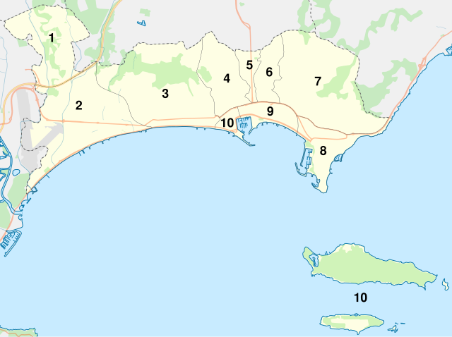
English: Map of districts of Cannes, Alpes-Maritimes, Provence-Alpes-Côte d'Azur, France.
Limites géographiques de la carte : |
||
| 日期 | (UTC) | ||
| 來源 | |||
| 作者 | |||
| 其他版本 | |||
| 姓名標示 (由许可协议要求) | © Sémhur / Wikimedia Commons / | ||
| SVG | W3C-validity not checked.
|
||
| Graphic Lab |

| 拍攝地點 | | 位於此地的本圖片與其他圖片: OpenStreetMap |
|---|
授權條款
[編輯]
| This work contains information from OpenStreetMap, which is made available under the Open Database License (ODbL).
The ODbL does not require any particular license for maps produced from ODbL data. Prior to 1 August 2020, map tiles produced by the OpenStreetMap Foundation were licensed under the CC-BY-SA-2.0 license. Maps produced by other people may be subject to other licences. |
我,本作品的著作權持有者,決定用以下授權條款發佈本作品:
| 公共版權:本藝術作品是自由的,您可以依據自由藝術作品許可協議的條款傳播和/或修改本藝術作品。您可以在Copyleft Attitude網站或其他網站找到該許可協議的樣本。 |
This file is licensed under the Creative Commons Attribution-Share Alike Attribution-Share Alike 4.0 International, 3.0 Unported, 2.5 Generic, 2.0 Generic and 1.0 Generic license.
- 您可以自由:
- 分享 – 複製、發佈和傳播本作品
- 重新修改 – 創作演繹作品
- 惟需遵照下列條件:
- 姓名標示 – 您必須指名出正確的製作者,和提供授權條款的連結,以及表示是否有對內容上做出變更。您可以用任何合理的方式來行動,但不得以任何方式表明授權條款是對您許可或是由您所使用。
- 相同方式分享 – 如果您利用本素材進行再混合、轉換或創作,您必須基於如同原先的相同或兼容的條款,來分布您的貢獻成品。
您可以選擇您需要的授權條款。
檔案歷史
點選日期/時間以檢視該時間的檔案版本。
| 日期/時間 | 縮圖 | 尺寸 | 用戶 | 備註 | |
|---|---|---|---|---|---|
| 目前 | 2012年10月24日 (三) 08:03 | | 1,305 × 974(212 KB) | Sémhur(對話 | 貢獻) | == {{int:filedesc}} == {{Information |Description={{Multilingual description |en= Map of districts of en:Cannes, Alpes-Maritimes, Provence-Alpes-Côte d'Azur, France. |fr= Carte des quartiers de fr:Cannes, Alpes-Maritimes, Provence-Alpes-C... |
無法覆蓋此檔案。
檔案用途
下列頁面有用到此檔案:
全域檔案使用狀況
以下其他 wiki 使用了這個檔案:
- eo.wikipedia.org 的使用狀況
- fr.wikipedia.org 的使用狀況
- Cannes
- Îles de Lérins
- Île Sainte-Marguerite (îles de Lérins)
- Stade Pierre-de-Coubertin (Cannes)
- Abbaye de Lérins
- Château Vallombrosa
- La Croisette
- La Bocca
- Cimetière du Grand Jas
- Institut Stanislas (Cannes)
- Musée du Masque de fer et du Fort Royal
- Musée des Explorations du monde
- Palais des Victoires
- Gare de Cannes-la-Bocca
- Gare du Bosquet
- Villa Domergue
- Villa Éléonore-Louise
- Château Thorenc
- Boulevard Carnot (Cannes)
- Villa Fiorentina (Cannes)
- Gare de La Frayère
- Hôtel Gray d'Albion
- Le Suquet
- Château du Suquet
- Tour du Suquet
- Chapelle Sainte-Anne de Cannes
- Baie de Cannes
- Place de la Castre
- Église Notre-Dame-d'Espérance de Cannes
- Villa La Californie
- Stade des Hespérides
- Villa Rothschild (Cannes)
- Villa Victoria (Cannes)
- Villa Romée
- Monument aux morts de Cannes
- Chapelle de la Miséricorde de Cannes
- Chapelle de la Trinité de Cannes
- Chapelle Saint-Sauveur (île Saint-Honorat)
- Fours à boulets des îles de Lérins
檢視此檔案的更多全域使用狀況。