File:RF-101C “Voodoo” (49870814823).jpg

Original file (6,000 × 4,000 pixels, file size: 9.84 MB, MIME type: image/jpeg)
Captions
Captions
Summary
[edit].jpg&action=edit§ion=1)
| Description |
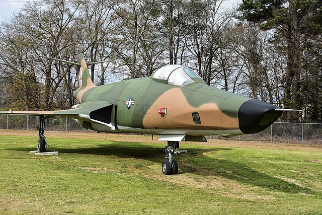
From the museum website: BY MCDONNELL The F-101 lineage included several versions: low-altitude fighter-bomber, photo-reconnaissance, two-seat interceptor and transition trainer. To accelerate production, no prototypes were built, and the first Voodoo, an F-101A, made its initial flight on 29 September 1954. When production ended in March 1961, nearly 800 Voodoos had been built. Development of the unarmed RF-101, the world’s first supersonic photo-recon aircraft, began in 1956. While 35 RF-101As and 166 RF-101Cs were produced, many earlier single-seat Voodoos were converted to reconnaissance configuration. Warner Robins Air Logistics Center provided logistics management of the communications, fire control and bomb navigation systems in all F-101 aircraft worldwide. The RF-101C on display was delivered to the USAF in July 1958 and assigned to the 66th Tactical Reconnaissance Wing at Loan AB, France. It served at various units in Europe and the US before being retired from the 186th Tactical Reconnaissance Group (ANG) at Key Field, Meridian, Mississippi in October 1978. It was transferred to the Museum in 1992. The aircraft is marked as it appeared while flying with the 4414th Tactical Reconnaissance Training Squadron, 363rd Tactical Reconnaissance Wing located at Shaw Air Force Base, South Carolina, during the early 1970s. SPECIFICATIONS: Span: 39 ft. 8 in. Length: 69 ft. 3 in. Height: 18 ft. Weight: 51,100 lbs. max. Armament: None Engines: Two Pratt & Whitney J57s of 15,000 lbs. thrust ea. with afterburner Cost: $1,276,245 Serial Number: 56-229 PERFORMANCE: Maximum speed: 1,000 mph. Cruising speed: 550 mph. Range: 2,060 miles Service ceiling: 45,800 ft. Photo by Eric Friedebach |
| Date | |
| Source | RF-101C “Voodoo” |
| Author | Eric Friedebach |
| Camera location | | View this and other nearby images on: OpenStreetMap |
|---|
.jpg¶ms=032.593602_N_-083.586006_E_globe:Earth_type:camera_source:Flickr_&language=en)
Licensing
[edit].jpg&action=edit§ion=2)
- You are free:
- to share – to copy, distribute and transmit the work
- to remix – to adapt the work
- Under the following conditions:
- attribution – You must give appropriate credit, provide a link to the license, and indicate if changes were made. You may do so in any reasonable manner, but not in any way that suggests the licensor endorses you or your use.
| This image was originally posted to Flickr by Eric Friedebach at https://flickr.com/photos/146295701@N02/49870814823. It was reviewed on 10 May 2020 by FlickreviewR 2 and was confirmed to be licensed under the terms of the cc-by-2.0. |
File history
Click on a date/time to view the file as it appeared at that time.
| Date/Time | Thumbnail | Dimensions | User | Comment | |
|---|---|---|---|---|---|
| current | 14:35, 10 May 2020 | | 6,000 × 4,000 (9.84 MB) | Tm (talk | contribs) | Transferred from Flickr via #flickr2commons |
You cannot overwrite this file.
File usage on Commons
There are no pages that use this file.
.jpg&oldid=615321686)