File:Railway Map Magdeburg-Wittenberge.png
Jump to navigation
Jump to search

Size of this preview: 485 × 599 pixels. Other resolutions: 194 × 240 pixels | 389 × 480 pixels | 622 × 768 pixels | 829 × 1,024 pixels | 2,024 × 2,500 pixels.
Original file (2,024 × 2,500 pixels, file size: 2.31 MB, MIME type: image/png)
Captions
Captions
Add a one-line explanation of what this file represents
| Description |
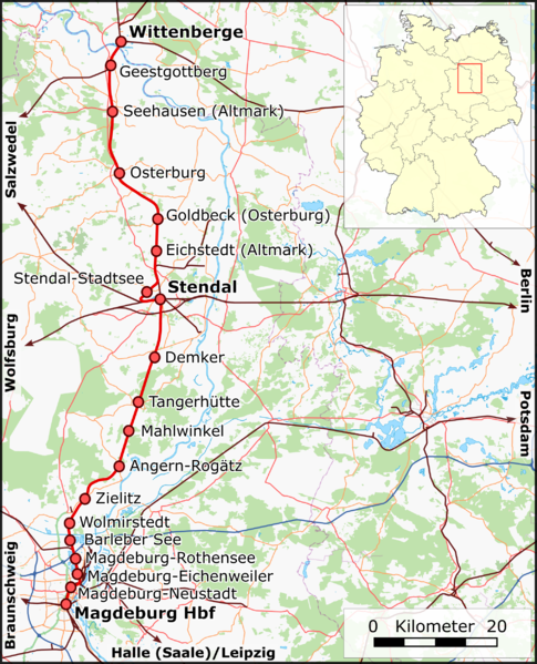
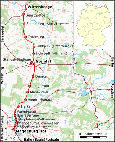
English: Railway Map Germany: Magdeburg-Wittenberge
Deutsch: Eisenbahnstrecke Magdeburg-Wittenberge |
| Date | |
| Source |
Deutsch: Eigene Arbeit, nutzt
English: Own work, uses
|
| Author | Muns |
| Description |
This map was created from OpenStreetMap project data, collected by the community. This map may be incomplete, and may contain errors. Don't rely solely on it for navigation. |
| Date | (see file history) |
| Source | openstreetmap.org |
| Creator |
OpenStreetMap contributors |
| Permission (Reusing this file) |
OpenStreetMap data and maps are licensed under the Creative Commons Attribution-ShareAlike 2.0 license (CC-BY-SA 2.0). This file is licensed under the Creative Commons Attribution-Share Alike 2.0 Generic license.
|
| Georeferencing | If inappropriate please set warp_status = skip to hide. |

|
This map has been made or improved in the German Kartenwerkstatt (Map Lab). You can propose maps to improve as well.
|
File history
Click on a date/time to view the file as it appeared at that time.
| Date/Time | Thumbnail | Dimensions | User | Comment | |
|---|---|---|---|---|---|
| current | 22:09, 7 June 2010 | | 2,024 × 2,500 (2.31 MB) | Muns (talk | contribs) | letzte Korrekturen (s. Diskussion in der Kartenwerkstatt) |
| 06:04, 3 June 2010 |  | 2,393 × 2,956 (2.78 MB) | Muns (talk | contribs) | Platzierung der Orte, zusätzliche Bahnhöfe, Farbgebung, M;aßstab | |
| 22:27, 28 May 2010 |  | 2,024 × 2,500 (2.12 MB) | Muns (talk | contribs) | {{Information |Description={{en|1=Railway Map Germany: Magdeburg-Wittenberge}} {{de|1=Eisenbahnstrecke Magdeburg-Wittenberge}} |Source={{de|Eigene Arbeit, basiert auf}} {{en|Own work, based on}} *File:Germany location map.svg, by [[User:NordNordWest| |
You cannot overwrite this file.
File usage on Commons
The following 3 pages use this file:
File usage on other wikis
The following other wikis use this file:
- Usage on de.wikipedia.org
- Usage on en.wikipedia.org
- Usage on pl.wikipedia.org
- Usage on www.wikidata.org