File:Rataje nad Sázavou and Ledečko.jpg
From Wikimedia Commons, the free media repository
Jump to navigation
Jump to search
![File:Rataje nad Sázavou and Ledečko.jpg](https://upload.wikimedia.org/wikipedia/commons/thumb/9/95/Rataje_nad_S%C3%A1zavou_and_Lede%C4%8Dko.jpg/403px-Rataje_nad_S%C3%A1zavou_and_Lede%C4%8Dko.jpg?20120915212806)
Size of this preview: 403 × 599 pixels. Other resolutions: 161 × 240 pixels | 323 × 480 pixels | 517 × 768 pixels | 689 × 1,024 pixels | 2,209 × 3,282 pixels.
Original file (2,209 × 3,282 pixels, file size: 2.26 MB, MIME type: image/jpeg)
File information
Structured data
Captions
Captions
Add a one-line explanation of what this file represents
Summary
[edit]DescriptionRataje nad Sázavou and Ledečko.jpg |
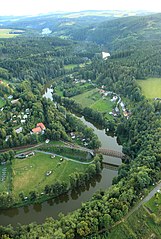
Čeština: Sázava mezi Ledečkem (vpravo) a Ratajemi nad Sázavou
English: Sázava river between Ledečko and Rataje nad Sázavou, Czech Republic |
Date | |
Source | www.flyfoto.cz |
Author | Zdeněk Fiedler, edited by Pavel Hrdlička (Packa) |
Permission (Reusing this file) |
![]() ![]() ![]() This file is licensed under the Creative Commons Attribution-Share Alike 3.0 Unported license.
|
Camera location | 49° 50′ 39.3″ N, 14° 56′ 47.7″ E ![]() | View this and other nearby images on: OpenStreetMap | ![]() |
---|
File history
Click on a date/time to view the file as it appeared at that time.
Date/Time | Thumbnail | Dimensions | User | Comment | |
---|---|---|---|---|---|
current | 21:28, 15 September 2012 | ![]() | 2,209 × 3,282 (2.26 MB) | Packa (talk | contribs) |
You cannot overwrite this file.
File usage on Commons
The following 2 pages use this file:
File usage on other wikis
The following other wikis use this file:
- Usage on pt.wikipedia.org
- Usage on uk.wikipedia.org
- Usage on zh-min-nan.wikipedia.org
Metadata
This file contains additional information such as Exif metadata which may have been added by the digital camera, scanner, or software program used to create or digitize it. If the file has been modified from its original state, some details such as the timestamp may not fully reflect those of the original file. The timestamp is only as accurate as the clock in the camera, and it may be completely wrong.
Camera manufacturer | Canon |
---|---|
Camera model | Canon EOS 550D |
Exposure time | 1/80 sec (0.0125) |
F-number | f/4 |
ISO speed rating | 200 |
Date and time of data generation | 18:43, 29 August 2012 |
Lens focal length | 17 mm |
Latitude | 49° 50′ 49.7″ N |
Longitude | 14° 57′ 2.21″ E |
Altitude | 555.65 meters above sea level |
Author | Zdeněk Fiedler http://www.flyfoto.cz/ |
Copyright holder |
|
Online copyright statement | http://www.flyfoto.cz/ |
Orientation | Normal |
Horizontal resolution | 72 dpi |
Vertical resolution | 72 dpi |
Software used | Adobe Photoshop CS2 Windows |
File change date and time | 12:49, 15 September 2012 |
Y and C positioning | Co-sited |
Exposure Program | Normal program |
Exif version | 2.21 |
Date and time of digitizing | 18:43, 29 August 2012 |
Meaning of each component |
|
APEX shutter speed | 6.375 |
APEX aperture | 4 |
APEX exposure bias | −0.33333333333333 |
Metering mode | Pattern |
Flash | Flash did not fire, compulsory flash suppression |
DateTime subseconds | 72 |
DateTimeOriginal subseconds | 72 |
DateTimeDigitized subseconds | 72 |
Supported Flashpix version | 1 |
Color space | sRGB |
Focal plane X resolution | 5,728.1767955801 |
Focal plane Y resolution | 5,808.4033613445 |
Focal plane resolution unit | inches |
Custom image processing | Normal process |
Exposure mode | Auto exposure |
White balance | Manual white balance |
Scene capture type | Standard |
GPS time (atomic clock) | 16:42 |
Geodetic survey data used | WGS-84 |
GPS date | 29 August 2012 |
GPS tag version | 0.0.2.2 |
Supported Flashpix version | 1 |
Image width | 2,209 px |
Image height | 3,282 px |
Compression scheme | JPEG (old) |
Contact information |
|
Category | letecké |
Date metadata was last modified | 14:49, 15 September 2012 |
Code for country shown | CZE |
Country shown | Česká republika |
IIM version | 2 |