File:Rb-map.png
Rb-map.png (328 × 352 pixels, file size: 13 KB, MIME type: image/png)
Captions
Captions
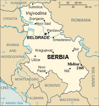
| Description | Map of the Republic of Serbia (FIPS 10 country code standard: RB) | |||
| Date | ||||
| Source | The World Factbook (published by CIA in 2008). | |||
| Author | Central Intelligence Agency of the Government of the United States of America | |||
| Permission (Reusing this file) |
|
|||
| Other versions | Recommend that Image:Sr-map.png should be deleted and Image:Serbia-CIA WFB Map.png should be spared to show how the map looked before 2008. |
Summary[edit]
Map of Serbia from The World Factbook archive copy at the Wayback Machine (published by CIA in 2008).
This map is updated with current events; independence of Kosovo and certain faults like BUL. is replaced with BULGARIA. The name of the country is in bold font, like the name of the Autonomous Province of Vojvodina (Northern Serbian province). Also the highest mountain in Serbia (Central Serbia region) is marked at the border with Bulgaria with the name of that peak - Midžor - and added the height in meters.
The name of the file[edit]
The National Geospatial-Intelligence Agency maintains the FIPS 10 country code standard that US Government use.
On 2006-07-11 the following changes have been made:
DELETE the following geopolitical entities and codes:
- YI SERBIA AND MONTENEGRO
- YI01 Crna Gora (Montenegro)
- YI02 Srbija (Serbia)
ADD the following geopolitical entity and code:
- MJ MONTENEGRO
ADD the following geopolitical entity and code:
- RB SERBIA
The notice was issued by:
Randall E. Flynn
Geographer
National Geospatial-Intelligence Agency
GEOnet Names Server at this web-site.
Recommend that Image:Sr-map.png should be deleted and Image:Serbia-CIA WFB Map.png should be spared to show how the map looked before 2008.
Licensing[edit]
This image is in the public domain because it contains materials that originally came from the United States Central Intelligence Agency's World Factbook.
|
 |
For enhancements[edit]
| I, the copyright holder of this work, release this work into the public domain. This applies worldwide. In some countries this may not be legally possible; if so: I grant anyone the right to use this work for any purpose, without any conditions, unless such conditions are required by law. |
File history
Click on a date/time to view the file as it appeared at that time.
| Date/Time | Thumbnail | Dimensions | User | Comment | |
|---|---|---|---|---|---|
| current | 21:22, 15 January 2014 | | 328 × 352 (13 KB) | Denniss (talk | contribs) | Reverted to version as of 19:30, 14 February 2008 |
| 21:13, 15 January 2014 |  | 328 × 352 (36 KB) | Ivan VA (talk | contribs) | updating borders | |
| 21:12, 15 January 2014 |  | 328 × 352 (36 KB) | Ivan VA (talk | contribs) | vandalizm | |
| 22:29, 2 January 2014 |  | 328 × 352 (13 KB) | No More Cats (talk | contribs) | oops, I got the wrong version | |
| 16:11, 2 January 2014 |  | 328 × 352 (13 KB) | No More Cats (talk | contribs) | Reverted to version as of 12:25, 28 February 2011 - original CIA map | |
| 13:53, 8 August 2013 |  | 328 × 352 (36 KB) | Pokrajac (talk | contribs) | Reverted to version as of 21:00, 11 February 2011 | |
| 12:25, 28 February 2011 |  | 328 × 352 (13 KB) | IJA (talk | contribs) | Reverted to version as of 19:30, 14 February 2008 | |
| 21:00, 11 February 2011 |  | 328 × 352 (36 KB) | Pokrajac (talk | contribs) | {{Information |Description=Map of the Republic of Serbia (FIPS 10 country code standard: RB) |Source=[https://www.cia.gov/library/publications/the-world-factbook/geos/rb.html The World Factbook] (published by CIA in 2008). |Date=2008-02-28 |Author=Central | |
| 19:30, 14 February 2008 |  | 328 × 352 (13 KB) | Imbris~commonswiki (talk | contribs) | {{Information |Description=Map of the Republic of Serbia (FIPS 10 country code standard: RB) |Source=[https://www.cia.gov/library/publications/the-world-factbook/geos/rb.html The World Factbook] (published by CIA in 2008). |Date=2008-06-15 |Author=Central |
You cannot overwrite this file.
File usage on Commons
The following page uses this file:
File usage on other wikis
The following other wikis use this file:
- Usage on de.wikipedia.org
- Usage on eo.wikipedia.org
- Usage on he.wikipedia.org
- Usage on nl.wiktionary.org
- Usage on to.wikipedia.org