File:Real Mosteiro de Santa Maria de Maceira Dão - Vila Garcia - Portugal (6711145965).jpg

Original file (7,304 × 4,870 pixels, file size: 8.89 MB, MIME type: image/jpeg)
Captions
Captions
Summary
[edit].jpg&action=edit§ion=1)
| Description |
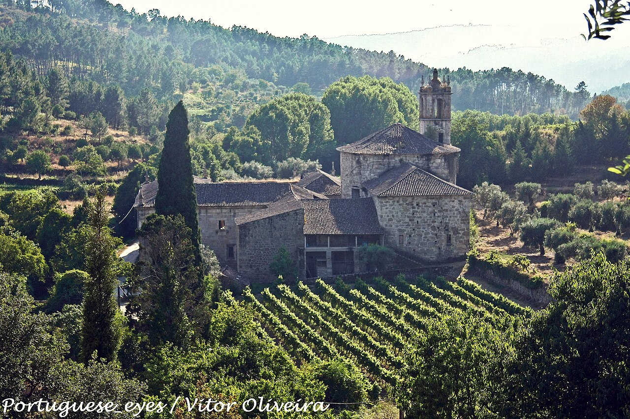
Fundado no séc. XII por D. Soeiro e seus companheiros, inicialmente obediente à Regra de S. Bento, cedo abraçaram seus monges a regra de Cister tornando-se obedientes a Alcobaça. O favor das gentes e o patrocínio dos reis que o tornaram, pela sua protecção, um Real Mosteiro, trouxeram o crescimento da casa e seus bens. Distinguem-se as seguintes partes na sua arquitectura: a torre medieval levantada entre os séculos XII-XV com os seus três pisos de adega e celeiro, hoje relativamente bem conservada; as edificações monásticas do séc. XVIII que tinham no piso térreo o claustro com fonte, a sala do capítulo, o refeitório, a cozinha, a adega, etc. e no piso superior os aposentos do Abade, a biblioteca, a enfermaria e as celas; a Igreja de Nossa Sra. da Assunção (séc. XVIII) apresenta uma singular frontaria em tronco de cilindro com as armas reais sobre a entrada. Ao lado, ergue-se a torre sineira. O corpo da igreja tem uma forma elíptica, com abóboda de tijolo. Foi classificado Monumento Nacional, Dec. n.º 5/2002, Diário da República 42, de 19 Fevereiro. <a href="http://www.cmmangualde.pt/index.php?option=com_content&view=article&id=217&Itemid=240" rel="nofollow">www.cmmangualde.pt/index.php?option=com_content&view=...</a> <a href="http://loc.alize.us/#/flickr:6711145965" rel="nofollow">See where this picture was taken.</a> <a href="https://www.flickr.com/groups/geotagging/discuss/72157594165549916/">[?]</a> |
| Date | |
| Source | Real Mosteiro de Santa Maria de Maceira Dão - Vila Garcia - Portugal |
| Author | Vitor Oliveira from Torres Vedras, PORTUGAL |
| Camera location | | View this and other nearby images on: OpenStreetMap |
|---|
.jpg¶ms=040.616670_N_-007.824767_E_globe:Earth_type:camera_source:Flickr_&language=en)
Licensing
[edit].jpg&action=edit§ion=2)
- You are free:
- to share – to copy, distribute and transmit the work
- to remix – to adapt the work
- Under the following conditions:
- attribution – You must give appropriate credit, provide a link to the license, and indicate if changes were made. You may do so in any reasonable manner, but not in any way that suggests the licensor endorses you or your use.
- share alike – If you remix, transform, or build upon the material, you must distribute your contributions under the same or compatible license as the original.
| This image was originally posted to Flickr by Portuguese_eyes at https://flickr.com/photos/21446942@N00/6711145965 (archive). It was reviewed on 15 April 2019 by FlickreviewR 2 and was confirmed to be licensed under the terms of the cc-by-sa-2.0. |
File history
Click on a date/time to view the file as it appeared at that time.
| Date/Time | Thumbnail | Dimensions | User | Comment | |
|---|---|---|---|---|---|
| current | 00:44, 15 April 2019 | | 7,304 × 4,870 (8.89 MB) | Tm (talk | contribs) | Transferred from Flickr via #flickr2commons |
You cannot overwrite this file.
File usage on Commons
There are no pages that use this file.
File usage on other wikis
The following other wikis use this file:
- Usage on fr.wikipedia.org
.jpg&oldid=889164507)