File:Regiões do Brasil (Milton Santos).svg
Jump to navigation
Jump to search

Size of this PNG preview of this SVG file: 681 × 600 pixels. Other resolutions: 273 × 240 pixels | 545 × 480 pixels | 872 × 768 pixels | 1,163 × 1,024 pixels | 2,325 × 2,048 pixels | 780 × 687 pixels.
Original file (SVG file, nominally 780 × 687 pixels, file size: 392 KB)
Captions
Captions
Add a one-line explanation of what this file represents
Summary[edit]
| Description |
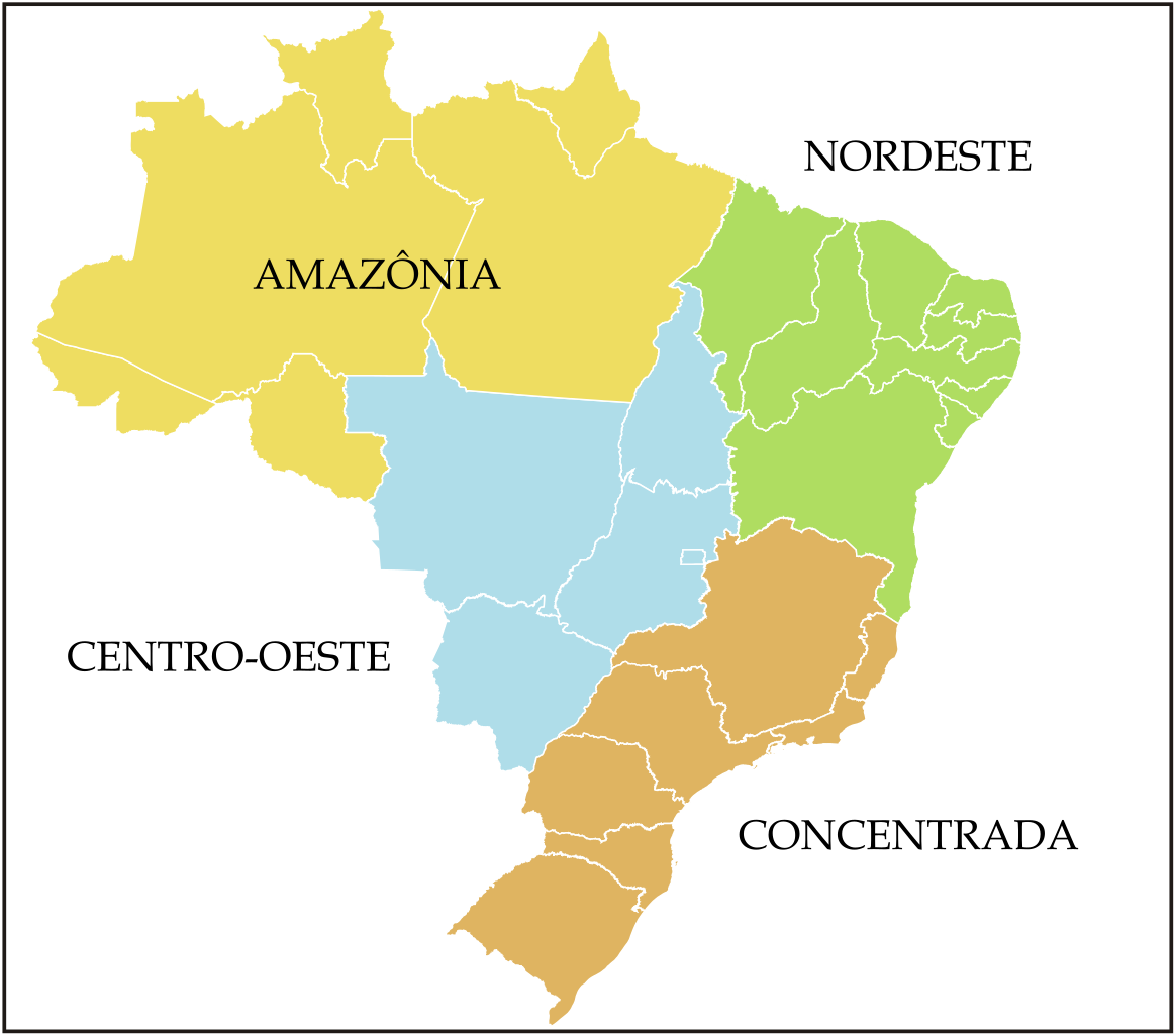
Português: Mapa das regiões do Brasil propostas por Milton Santos e Maria Laura Silveira (fonte das informações: MUDANÇAS QUE ESTÃO NO MAPA).
This W3C-unspecified vector image was created with Inkscape . |
||||||
| Date | (UTC) | ||||||
| Source |
This file was derived from: Brazilian States.svg: |
||||||
| Author | |||||||
| Other versions |
|

.svg)
_-_Nmbrs_-_colored.svg)
.svg&action=edit§ion=1)
Licensing[edit]
.svg&action=edit§ion=2)
This file is licensed under the Creative Commons Attribution-Share Alike 3.0 Brazil license.
- You are free:
- to share – to copy, distribute and transmit the work
- to remix – to adapt the work
- Under the following conditions:
- attribution – You must give appropriate credit, provide a link to the license, and indicate if changes were made. You may do so in any reasonable manner, but not in any way that suggests the licensor endorses you or your use.
- share alike – If you remix, transform, or build upon the material, you must distribute your contributions under the same or compatible license as the original.


|
I'd greatly appreciate, that you attribute this media file to Wikimedia Commons, if used outside Wikipedia or Commons. For use in publications such as books, newspapers, blogs, websites, please insert here the following line:
Attribution: Luan
|
.svg&action=edit&redlink=1)
Original upload log[edit]
.svg&action=edit§ion=3)
This image is a derivative work of the following images:
- File:Brazilian_States.svg licensed with Cc-by-sa-2.5,2.0,1.0, Cc-by-sa-3.0-migrated, GFDL
- 2007-06-12T00:03:21Z Felipe Menegaz 780x687 (652526 Bytes) {{User:João Felipe C.S/by}} {{Information |Description= {{en|Map of Brazilian states divisions.}} {{pt|Mapa das divisões dos estados brasileiros.}} ---- {{Inkscape}} |Source= Own work |Date= June 11, 2007 |Author= [[User:J
Uploaded with derivativeFX
File history
Click on a date/time to view the file as it appeared at that time.
| Date/Time | Thumbnail | Dimensions | User | Comment | |
|---|---|---|---|---|---|
| current | 00:52, 18 January 2014 | | 780 × 687 (392 KB) | Luan (talk | contribs) | == {{int:filedesc}} == {{Information |Description={{pt|Mapa das regiões do Brasil em 1938.}} ---- {{Inkscape}} |Source={{Derived from|Brazilian_States.svg|display=50}} *a partir de informações de [http://www.geografiaparat... |
You cannot overwrite this file.
File usage on Commons
The following 3 pages use this file:
File usage on other wikis
The following other wikis use this file:
- Usage on pt.wikipedia.org
- Usage on www.wikidata.org
.svg&oldid=651776815)