File:Rensselaer County New York.svg
Jump to navigation
Jump to search

Size of this PNG preview of this SVG file: 527 × 599 pixels. Other resolutions: 211 × 240 pixels | 422 × 480 pixels | 675 × 768 pixels | 901 × 1,024 pixels | 1,801 × 2,048 pixels | 621 × 706 pixels.
Original file (SVG file, nominally 621 × 706 pixels, file size: 45 KB)
Captions
Captions
Add a one-line explanation of what this file represents
Summary[edit]
| Description |
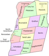
English: Map of Rensselaer County, New York, United States showing its constituent cities, towns, and villages |
| Date | |
| Source | Edited from sub-county state map found at the Libre Map Project which is offered under a Creative Commons License. |
| Author | UpstateNYer and ZooFari |
| Other versions |
|


Licensing[edit]
This file is licensed under the Creative Commons Attribution 3.0 Unported license.
- You are free:
- to share – to copy, distribute and transmit the work
- to remix – to adapt the work
- Under the following conditions:
- attribution – You must give appropriate credit, provide a link to the license, and indicate if changes were made. You may do so in any reasonable manner, but not in any way that suggests the licensor endorses you or your use.
File history
Click on a date/time to view the file as it appeared at that time.
| Date/Time | Thumbnail | Dimensions | User | Comment | |
|---|---|---|---|---|---|
| current | 03:13, 3 January 2010 | | 621 × 706 (45 KB) | ZooFari (talk | contribs) | == Summary == {{Information |Description=Map of Rensselaer County, New York with towns and cities labeled. |Source=Edited from sub-county state map found at the [http://libremap.org/data/boundary/ Libre Map Project] whi |
You cannot overwrite this file.
File usage on Commons
The following 4 pages use this file: