File:Republic of Venice 1796.png
Jump to navigation
Jump to search

Size of this preview: 610 × 600 pixels. Other resolutions: 244 × 240 pixels | 488 × 480 pixels | 781 × 768 pixels | 1,026 × 1,009 pixels.
Original file (1,026 × 1,009 pixels, file size: 115 KB, MIME type: image/png)
Captions
Captions
Add a one-line explanation of what this file represents
Summary[edit]
| Description |
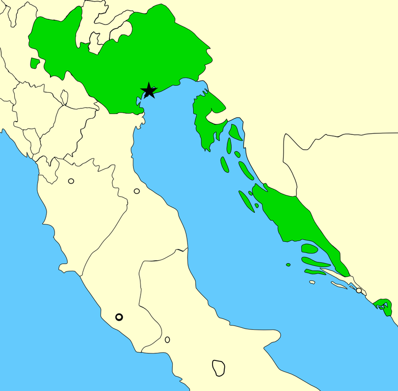
A map showing the territories of the Republic of Venice in the year 1796, before the Napoleonic invasions of that year. Please note that the Venetian-held Ionian Islands are not shown on this map; for a map of these possessions, see Image:Europe 1740.jpg. Created by MapMaster using Image:Italy 1796.png as base. |
| Date | 22 November 2006 (original upload date) |
| Source | No machine-readable source provided. Own work assumed (based on copyright claims). |
| Author | No machine-readable author provided. MapMaster assumed (based on copyright claims). |
Licensing[edit]
I, the copyright holder of this work, hereby publish it under the following license:

|
Permission is granted to copy, distribute and/or modify this document under the terms of the GNU Free Documentation License, Version 1.2 or any later version published by the Free Software Foundation; with no Invariant Sections, no Front-Cover Texts, and no Back-Cover Texts. A copy of the license is included in the section entitled GNU Free Documentation License. |
| This file is licensed under the Creative Commons Attribution-Share Alike 3.0 Unported license. | ||
| ||
| This licensing tag was added to this file as part of the GFDL licensing update. |
File history
Click on a date/time to view the file as it appeared at that time.
| Date/Time | Thumbnail | Dimensions | User | Comment | |
|---|---|---|---|---|---|
| current | 00:18, 30 June 2014 | | 1,026 × 1,009 (115 KB) | Ras67 (talk | contribs) | cropped |
| 15:20, 24 February 2008 |  | 1,040 × 1,023 (141 KB) | MapMaster (talk | contribs) | Added small territory | |
| 03:56, 24 November 2006 |  | 765 × 785 (88 KB) | MapMaster (talk | contribs) | Now including the Bocche di Cattaro (Bay of Kotor), as suggested by 213 | |
| 05:43, 22 November 2006 |  | 736 × 763 (90 KB) | MapMaster (talk | contribs) | A map showing the territories of the Republic of Venice in the year 1796, before the Napoleonic invasions of that year. |
You cannot overwrite this file.
File usage
The following 5 pages use this file:
Global file usage
The following other wikis use this file:
- Usage on an.wikipedia.org
- Usage on ar.wikipedia.org
- Usage on az.wikipedia.org
- Usage on be-tarask.wikipedia.org
- Usage on be.wikipedia.org
- Usage on bg.wikipedia.org
- Usage on br.wikipedia.org
- Usage on ca.wikipedia.org
- Usage on da.wikipedia.org
- Usage on de.wikipedia.org
- Usage on en.wikipedia.org
- Usage on eo.wikipedia.org
- Usage on et.wikipedia.org
- Usage on eu.wikipedia.org
- Usage on fo.wikipedia.org
- Usage on fr.wikipedia.org
- Usage on fy.wikipedia.org
- Usage on gl.wikipedia.org
- Usage on hr.wikipedia.org
- Usage on hu.wikipedia.org
- Usage on id.wikipedia.org
- Usage on incubator.wikimedia.org
- Usage on it.wikipedia.org
- Usage on ja.wikipedia.org
- Usage on lmo.wikipedia.org
- Usage on lt.wikipedia.org
- Usage on lv.wikipedia.org
- Usage on mk.wikipedia.org
- Usage on nds.wikipedia.org
- Usage on nl.wikipedia.org
View more global usage of this file.