File:Rheinkorrekturplan.png
Jump to navigation
Jump to search

Size of this preview: 199 × 599 pixels. Other resolutions: 79 × 240 pixels | 338 × 1,017 pixels.
Original file (338 × 1,017 pixels, file size: 105 KB, MIME type: image/png)
Captions
Captions
Add a one-line explanation of what this file represents
Summary
[edit]
| Description |
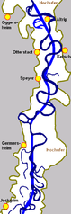
English: plan of the Rhine River in the 19th century
Français : Les ripisylves reculent aussi à cause de la canalisation et rectification des fleuves (ex : Rhin)
Deutsch: Ein ursprünglicher Plan zur Rheinbegradigung stromabwärts von Karlsruhe bis vor Mannheim (45 km)
Source: own work |
| Date | 12 December 2005 (original upload date) |
| Source | No machine-readable source provided. Own work assumed (based on copyright claims). |
| Author | No machine-readable author provided. Immanuel Giel assumed (based on copyright claims). |
Licensing
[edit]
| I, the copyright holder of this work, release this work into the public domain. This applies worldwide. In some countries this may not be legally possible; if so: I grant anyone the right to use this work for any purpose, without any conditions, unless such conditions are required by law. |
File history
Click on a date/time to view the file as it appeared at that time.
| Date/Time | Thumbnail | Dimensions | User | Comment | |
|---|---|---|---|---|---|
| current | 09:15, 12 December 2005 | 338 × 1,017 (105 KB) | Immanuel Giel (talk | contribs) | '''Description''': plan of the Rhine River in the 19th century <br> '''Source''': own work<br> '''Date''': December 2005 <br> '''Author''': --~~~~ <br> '''Other versions''': none<br> Category:Rivers de:Rheinbegradigung |
You cannot overwrite this file.
File usage on Commons
The following page uses this file:
File usage on other wikis
The following other wikis use this file:
- Usage on de.wikipedia.org
- Usage on fr.wikipedia.org
- Usage on hu.wikipedia.org
- Usage on nl.wikipedia.org