File:Ribble Valley UK locator map.svg
Salta a la navegació
Salta a la cerca

Mida d'aquesta previsualització PNG del fitxer SVG: 513 × 600 píxels. Altres resolucions: 205 × 240 píxels | 410 × 480 píxels | 657 × 768 píxels | 876 × 1.024 píxels | 1.751 × 2.048 píxels | 1.116 × 1.305 píxels.
Fitxer original (fitxer SVG, nominalment 1.116 × 1.305 píxels, mida del fitxer: 1,25 Mo)
Llegendes
Llegendes
Afegeix una explicació d'una línia del que representa aquest fitxer
| Descripció |
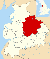
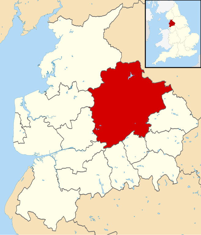
Map of Lancashire, UK with Ribble Valley highlighted. Equirectangular map projection on WGS 84 datum, with N/S stretched 165% |
| Data | |
| Font | Ordnance Survey OpenData. Most data from Boundary-Line product. Lake data from Meridian 2 product. Inset derived from England location map.svg by Spischot. |
| Autor | Nilfanion, created using Ordnance Survey data |
| Permís (Com reutilitzar aquest fitxer) |
Aquest fitxer està subjecte a la llicència de Creative Commons Reconeixement i Compartir Igual 3.0 No adaptada. Reconeixement: Contains Ordnance Survey data © Crown copyright and database right
|
Historial del fitxer
Cliqueu una data/hora per veure el fitxer tal com era aleshores.
| Data/hora | Miniatura | Dimensions | Usuari/a | Comentari | |
|---|---|---|---|---|---|
| actual | 20:45, 1 set 2013 | | 1.116 × 1.305 (1,25 Mo) | Nilfanion (discussió | contribucions) | {{Information |Description=Map of Lancashire, UK with Ribble Valley highlighted. Equirectangular map projection on WGS 84 datum, with N/S stretched 165% |Source=Ordnance Survey [https://www.ordnancesurvey.co.uk/o... |
No podeu sobreescriure aquest fitxer.
Ús del fitxer
La pàgina següent utilitza aquest fitxer:
Ús global del fitxer
Utilització d'aquest fitxer en altres wikis:
- Utilització a ca.wikipedia.org
- Utilització a cy.wikipedia.org
- Utilització a en.wikipedia.org
- Utilització a es.wikipedia.org
- Utilització a fr.wikipedia.org
- Clitheroe
- Whalley (Lancashire)
- Ribchester
- Ribble Valley
- Billington (Lancashire)
- Modèle:Palette Ribble Valley
- Balderstone (Lancashire)
- Barrow (Lancashire)
- Bashall Eaves
- Bolton-by-Bowland
- Chatburn
- Chipping (Lancashire)
- Clayton-le-Dale
- Dinckley
- Downham (Lancashire)
- Gisburn
- Great Mitton
- Grindleton
- Horton (Lancashire)
- Mellor (Lancashire)
- Middop
- Newsholme (Lancashire)
- Newton-in-Bowland
- Osbaldeston
- Paythorne
- Pendleton (Lancashire)
- Read (Lancashire)
- Rimington
- Sabden
- Salesbury
- Sawley (Lancashire)
- Simonstone (Lancashire)
- Slaidburn
- Twiston
- Waddington (Lancashire)
- West Bradford (Lancashire)
- Wilpshire
- Wiswell
- Worston
- Utilització a ko.wikipedia.org
- Utilització a lt.wikipedia.org
- Utilització a nl.wikipedia.org
- Utilització a pl.wikipedia.org
- Utilització a pt.wikipedia.org
- Utilització a ro.wikipedia.org
- Utilització a ru.wikipedia.org
Vegeu més usos globals d'aquest fitxer.