File:Richmond (1862-1865) LOC 2009583302.jpg
Jump to navigation
Jump to search

Size of this preview: 800 × 535 pixels. Other resolutions: 320 × 214 pixels | 640 × 428 pixels | 1,024 × 685 pixels | 1,280 × 856 pixels | 2,560 × 1,711 pixels | 14,164 × 9,469 pixels.
Original file (14,164 × 9,469 pixels, file size: 30.69 MB, MIME type: image/jpeg)
Captions
Captions
Add a one-line explanation of what this file represents
Summary
[edit]| Warning | The original file is very high-resolution. It might not load properly or could cause your browser to freeze when opened at full size. |
|---|
| Description |
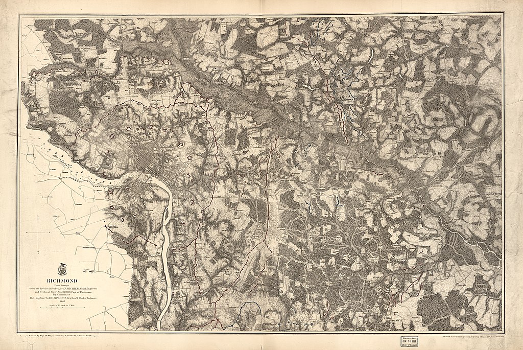
English: LC Civil War Maps (2nd ed.), 632.8 Detailed topographic map of the environs of Richmond showing Confederate fortifications in red, Union fortifications in blue, roads, street pattern of Richmond and Manchester, railroads, towns, vegetation, drainage, hachures, houses, and names of residents. Description derived from published bibliography. Available also through the Library of Congress web site as raster image. |
||
| Title | Richmond [1862-1865] | ||
| Shelf ID | G3884.R5S5 1867 .M51 G3884.R5S5 1867 .M51 | ||
| Date | |||
| Source | https://www.loc.gov/item/2009583302/ | ||
| Author | Michler, N. (Nathaniel); Michie, Peter Smith; Michler, N. | ||
| Permission (Reusing this file) |
|
||
| Location | Richmond · United States · Virginia | ||
| Part of | Military Battles And Campaigns · American Memory · Civil War Maps · Catalog · Geography And Map Division | ||
| Subject | Richmond · Richmond (Va.) · Virginia · Civil War · United States · Maps · History |

_LOC_2009583302.jpg&action=edit§ion=1)
_LOC_2009583302.jpg&flash=no)
Licensing
[edit]_LOC_2009583302.jpg&action=edit§ion=2)
|
This is a faithful photographic reproduction of a two-dimensional, public domain work of art. The work of art itself is in the public domain for the following reason:
The official position taken by the Wikimedia Foundation is that "faithful reproductions of two-dimensional public domain works of art are public domain".
This photographic reproduction is therefore also considered to be in the public domain in the United States. In other jurisdictions, re-use of this content may be restricted; see Reuse of PD-Art photographs for details. | ||||
File history
Click on a date/time to view the file as it appeared at that time.
| Date/Time | Thumbnail | Dimensions | User | Comment | |
|---|---|---|---|---|---|
| current | 21:12, 8 July 2018 | | 14,164 × 9,469 (30.69 MB) | Fæ (talk | contribs) | LOC Maps https://www.loc.gov/item/2009583302/ #472 |
You cannot overwrite this file.
File usage on Commons
There are no pages that use this file.
_LOC_2009583302.jpg&oldid=664347803)