File:Ricketts Glen State Park Map.png
Jump to navigation
Jump to search
Size of this preview: 778 × 599 pixels. Other resolutions: 312 × 240 pixels | 623 × 480 pixels | 997 × 768 pixels | 1,280 × 986 pixels | 1,676 × 1,291 pixels.
Original file (1,676 × 1,291 pixels, file size: 128 KB, MIME type: image/png)
Captions
Captions
Add a one-line explanation of what this file represents
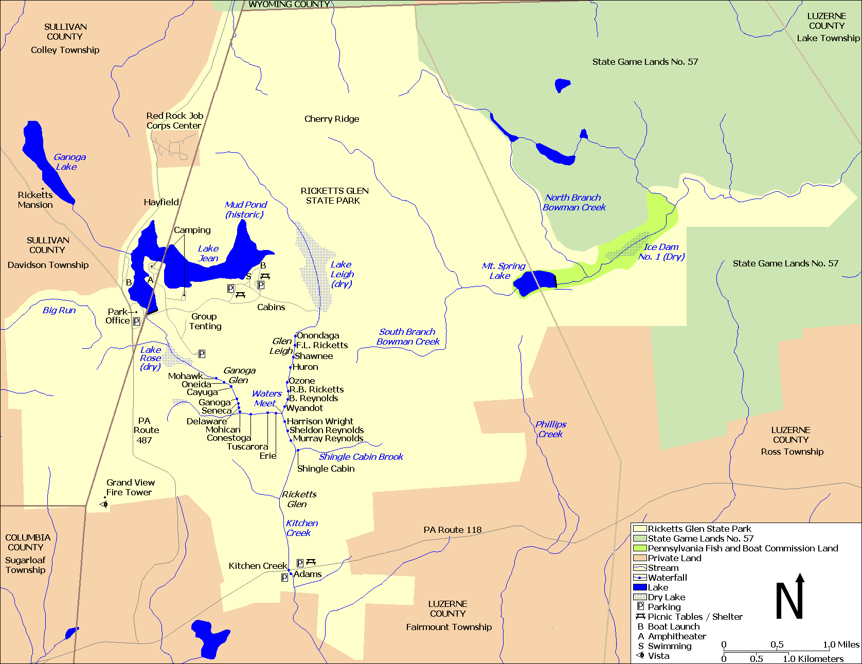
| Description | Map of Ricketts Glen State Park, in Columbia, Luzerne, and Sullivan Counties, Pennsylvania, USA |
| Date | |
| Source | water, roads, some park boundaries taken from US Census website [1] and modified by User:Ruhrfisch, property boundaries based on this PennDOT map and the following map, facilities based on this PA DCNR map. |
| Author | US Census, Ruhrfisch |
| Permission (Reusing this file) |
US Census / US Government work is public domain, my modifications licensed under the GNU Free Documentation License |
Note: Color scheme - ivory is Ricketts Glen State Park, light green is State Game Lands, bright green is Pennsylvania Fish and Boat Commission land, and brown is private land.
Licensing
[edit]
I, Ruhrfisch, the copyright holder of this work, hereby publishes it under the following licenses:

|
Permission is granted to copy, distribute and/or modify this document under the terms of the GNU Free Documentation License, Version 1.2 or any later version published by the Free Software Foundation; with no Invariant Sections, no Front-Cover Texts, and no Back-Cover Texts. A copy of the license is included in the section entitled GNU Free Documentation License. |
| This file is licensed under the Creative Commons Attribution-Share Alike 3.0 Unported license. | ||
| Attribution: I, Ruhrfisch | ||
| ||
| This licensing tag was added to this file as part of the GFDL licensing update. |
You may select the license of your choice.
and
This image or file is a work of a United States Census Bureau employee, taken or made as part of that person's official duties. As a work of the U.S. federal government, the image is in the public domain.
|
 |
File history
Click on a date/time to view the file as it appeared at that time.
| Date/Time | Thumbnail | Dimensions | User | Comment | |
|---|---|---|---|---|---|
| current | 15:16, 22 July 2010 | | 1,676 × 1,291 (128 KB) | Ruhrfisch (talk | contribs) | Add labels for Cherry Ridge, Hayfield, Ricketts Mansion - all other information is the same |
| 20:27, 7 April 2010 |  | 1,676 × 1,291 (127 KB) | Ruhrfisch (talk | contribs) | Change colors to avoid so much yellow | |
| 22:41, 1 April 2010 |  | 1,676 × 1,291 (127 KB) | Ruhrfisch (talk | contribs) | {{Information| |Description= Map of {{w|Ricketts Glen State Park}}, in Columbia, Luzerne, and Sullivan Counties, Pennsylvania, USA |Source= water, roads, some park boundaries taken from US Census website [http://factfinder.census.gov/] and modified by [ |
You cannot overwrite this file.
File usage on Commons
There are no pages that use this file.
File usage on other wikis
The following other wikis use this file:
- Usage on en.wikipedia.org