File:Riesengebirge Karte.png
Jump to navigation
Jump to search

Size of this preview: 800 × 513 pixels. Other resolutions: 320 × 205 pixels | 640 × 410 pixels | 1,024 × 656 pixels | 1,280 × 821 pixels | 2,262 × 1,450 pixels.
Original file (2,262 × 1,450 pixels, file size: 3.93 MB, MIME type: image/png)
Captions
Captions
Add a one-line explanation of what this file represents
Summary
[edit]
| Description |
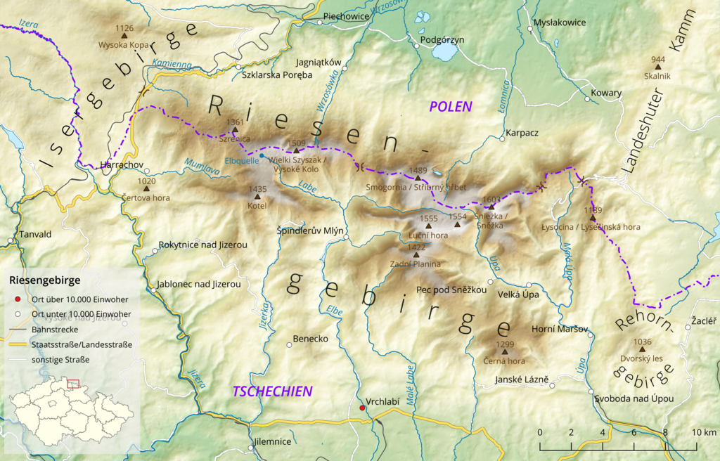
Deutsch: Karte des Riesengebirges. Entwurfsversion, bitte noch nicht im Artikel verwenden |
|||
| Date | ||||
| Source |
Own work, using
|
|||
| Author | Földhegy | |||
| Permission (Reusing this file) |
This file is licensed under the Creative Commons Attribution-Share Alike 3.0 Unported license.
|

|
This map has been made or improved in the German Kartenwerkstatt (Map Lab). You can propose maps to improve as well.
|
File history
Click on a date/time to view the file as it appeared at that time.
| Date/Time | Thumbnail | Dimensions | User | Comment | |
|---|---|---|---|---|---|
| current | 16:15, 2 January 2021 | | 2,262 × 1,450 (3.93 MB) | Földhegy (talk | contribs) | new version with some additions and corrections |
| 22:09, 13 August 2020 |  | 2,263 × 1,440 (3.43 MB) | Földhegy (talk | contribs) | == {{int:filedesc}} == {{Information |Description={{de|Karte des {{w|Riesengebirge|Riesengebirges|de}}. '''Entwurfsversion''', bitte noch nicht im Artikel verwenden }} |Source={{own}}, using * OpenStreetMap data * Copernicus data and information funded by the European Union - [https://opendem.info/opendemeu_download_highres.html EU-DEM] layers |Date=2020-08-13 |Author={{u|Földhegy}} |Permission={{ODbL OpenStreetMap}} {{CC-BY-SA-3.0}} |other_versions= }} {{Kartenwerkstatt}} [[Category:Maps... |
You cannot overwrite this file.
File usage on Commons
There are no pages that use this file.
File usage on other wikis
The following other wikis use this file:
- Usage on de.wikipedia.org