File:Roadless & undeveloped area evaluation II, RARE II, final environmental statement, January 1979 - West Virginia. LOC 2007626186.jpg
Jump to navigation
Jump to search

Size of this preview: 658 × 599 pixels. Other resolutions: 264 × 240 pixels | 527 × 480 pixels | 843 × 768 pixels | 1,124 × 1,024 pixels | 2,249 × 2,048 pixels | 11,081 × 10,093 pixels.
Original file (11,081 × 10,093 pixels, file size: 13.45 MB, MIME type: image/jpeg)
Captions
Captions
Add a one-line explanation of what this file represents
Summary
[edit]| Warning | The original file is very high-resolution. It might not load properly or could cause your browser to freeze when opened at full size. |
|---|
| Description |
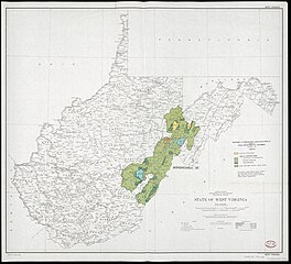
English: Shows wilderness recommendation areas, nonwilderness areas, and other national forest system lands. Relief shown by spot heights. In upper and lower right corners: West Virginia. Base map "Compiled, edited, and published by the Geological Survey." "*U.S. Government Printing Office: 1979--650-774." Available also through the Library of Congress Web site as a raster image. |
||
| Title | Roadless & undeveloped area evaluation II, RARE II, final environmental statement, January 1979 : West Virginia. | ||
| Shelf ID | G3891.G3 1979 .U5 | ||
| Date | |||
| Source | https://www.loc.gov/item/2007626186/ | ||
| Author | United States. Forest Service; Geological Survey (U.S.) | ||
| Permission (Reusing this file) |
|
||
| Other versions |
|
||
| Location | United States · West Virginia. · West Virginia | ||
| Part of | American Memory · General Maps · Catalog · Geography And Map Division · Additional Conservation And Environment Cartographic Items | ||
| Subject | Regional Planning · Wilderness Areas · United States · Maps · Planning · Environmental Policy · West Virginia |


Licensing
[edit]
This work is in the public domain in the United States because it is a work prepared by an officer or employee of the United States Government as part of that person’s official duties under the terms of Title 17, Chapter 1, Section 105 of the US Code.
Note: This only applies to original works of the Federal Government and not to the work of any individual U.S. state, territory, commonwealth, county, municipality, or any other subdivision. This template also does not apply to postage stamp designs published by the United States Postal Service since 1978. (See § 313.6(C)(1) of Compendium of U.S. Copyright Office Practices). It also does not apply to certain US coins; see The US Mint Terms of Use.
|
 | |
| This file has been identified as being free of known restrictions under copyright law, including all related and neighboring rights. | ||
File history
Click on a date/time to view the file as it appeared at that time.
| Date/Time | Thumbnail | Dimensions | User | Comment | |
|---|---|---|---|---|---|
| current | 07:23, 30 June 2019 | | 11,081 × 10,093 (13.45 MB) | Fæ (talk | contribs) | LOC Maps https://www.loc.gov/item/2007626186/ #24333 |
You cannot overwrite this file.
File usage on Commons
The following page uses this file: