File:Rokycany District 2010 names RO CZ.png
Jump to navigation
Jump to search

Size of this preview: 484 × 600 pixels. Other resolutions: 194 × 240 pixels | 387 × 480 pixels | 702 × 870 pixels.
Original file (702 × 870 pixels, file size: 101 KB, MIME type: image/png)
Captions
Captions
Add a one-line explanation of what this file represents
| Description |
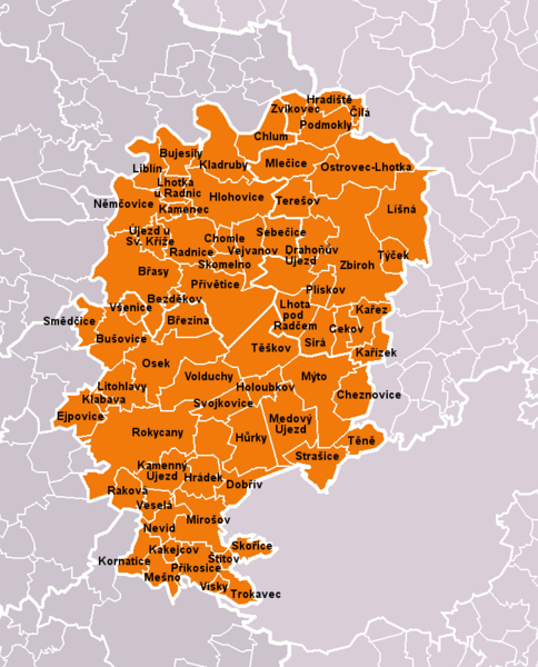
Čeština: Obce okresu Rokycany dle stavu k roku 2010 (68 obcí). Bílé linie o různé tloušťce představují hranice obcí, správních obvodů, okresů a krajů. S územím okresu je rozsahem totožný správní obvod obce s rozšířenou působností Rokycany.
English: Municipalities of Rokycany District as of 2010 (68 municipalities in total). White lines of variable thickness show boundaries of municipalities, administrative areas, districts and regions. The territory is identical with administrative area of Rokycany as a Municipality with Extended Competence. |
| Date | |
| Source | Self made, based on File:Rokycany District 2010 RO CZ.png |
| Author | User:Miaow Miaow |
| Permission (Reusing this file) |
PD-self |
| Other versions |
|

Licensing[edit]
| I, the copyright holder of this work, release this work into the public domain. This applies worldwide. In some countries this may not be legally possible; if so: I grant anyone the right to use this work for any purpose, without any conditions, unless such conditions are required by law. |
File history
Click on a date/time to view the file as it appeared at that time.
| Date/Time | Thumbnail | Dimensions | User | Comment | |
|---|---|---|---|---|---|
| current | 21:40, 14 March 2010 | | 702 × 870 (101 KB) | Miaow Miaow (talk | contribs) | {{Information |Description={{cs|'''Obce okresu Rokycany''' dle stavu k roku 2010 (68 obcí). Bílé linie o různé tloušťce představují hranice obcí, správních obvodů, okresů a krajů. S územím okresu je rozsahem totožn |
You cannot overwrite this file.
File usage on Commons
The following 69 pages use this file:
- File:Bezdekov RO CZ.png
- File:Brasy RO CZ.png
- File:Brezina RO CZ.png
- File:Bujesily RO CZ.png
- File:Busovice RO CZ.png
- File:Cekov RO CZ.png
- File:Cheznovice RO CZ.png
- File:Chlum RO CZ.png
- File:Chomle RO CZ.png
- File:Cila RO CZ.png
- File:Dobriv RO CZ.png
- File:Drahonuv Ujezd RO CZ.png
- File:Ejpovice RO CZ.png
- File:Hlohovice RO CZ.png
- File:Holoubkov RO CZ.png
- File:Hradek RO CZ.png
- File:Hradiste RO CZ.png
- File:Hurky RO CZ.png
- File:Kakejcov RO CZ.png
- File:Kamenec RO CZ.png
- File:Kamenny Ujezd RO CZ.png
- File:Karez RO CZ.png
- File:Karizek RO CZ.png
- File:Klabava RO CZ.png
- File:Kladruby RO CZ.png
- File:Kornatice RO CZ.png
- File:Lhota pod Radcem RO CZ.png
- File:Lhotka u Radnic RO CZ.png
- File:Liblin RO CZ.png
- File:Lisna RO CZ.png
- File:Litohlavy RO CZ.png
- File:Medovy Ujezd RO CZ.png
- File:Mesno RO CZ.png
- File:Mirosov RO CZ.png
- File:Mlecice RO CZ.png
- File:Myto RO CZ.png
- File:Nemcovice RO CZ.png
- File:Nevid RO CZ.png
- File:Osek RO CZ.png
- File:Ostrovec-Lhotka RO CZ.png
- File:Pliskov RO CZ.png
- File:Podmokly RO CZ.png
- File:Prikosice RO CZ.png
- File:Privetice RO CZ.png
- File:Radnice RO CZ.png
- File:Rakova RO CZ.png
- File:Rokycany District 2010 RO CZ.png
- File:Rokycany RO CZ.png
- File:Sebecice RO CZ.png
- File:Sira RO CZ.png
- File:Skomelno RO CZ.png
- File:Skorice RO CZ.png
- File:Smedcice RO CZ.png
- File:Stitov RO CZ.png
- File:Strasice RO CZ.png
- File:Svojkovice RO CZ.png
- File:Tene RO CZ.png
- File:Teresov RO CZ.png
- File:Teskov RO CZ.png
- File:Trokavec RO CZ.png
- File:Tycek RO CZ.png
- File:Ujezd u Svateho Krize RO CZ.png
- File:Vejvanov RO CZ.png
- File:Vesela RO CZ.png
- File:Visky RO CZ.png
- File:Volduchy RO CZ.png
- File:Vsenice RO CZ.png
- File:Zbiroh RO CZ.png
- File:Zvikovec RO CZ.png
File usage on other wikis
The following other wikis use this file:
- Usage on azb.wikipedia.org
- Usage on bg.wikipedia.org
- Usage on cs.wikipedia.org
- Usage on de.wikipedia.org
- Usage on en.wikipedia.org
- Usage on eo.wikipedia.org
- Usage on fa.wikipedia.org
- Usage on fr.wikipedia.org
- Usage on hu.wikipedia.org
- Usage on it.wikipedia.org
- Usage on ko.wikipedia.org
- Usage on ms.wikipedia.org
- Usage on nl.wikipedia.org
- Usage on pl.wikipedia.org
- Usage on pnb.wikipedia.org
- Usage on pt.wikipedia.org
- Usage on ru.wikipedia.org
- Usage on sk.wikipedia.org
- Usage on war.wikipedia.org
- Usage on zh.wikipedia.org