File:Roma Plan.jpg
出自Wikimedia Commons
跳至導覽
跳至搜尋

預覽大小:754 × 600 像素。 其他解析度:302 × 240 像素 | 604 × 480 像素 | 966 × 768 像素 | 1,280 × 1,018 像素 | 1,840 × 1,463 像素。
原始檔案 (1,840 × 1,463 像素,檔案大小:2.5 MB,MIME 類型:image/jpeg)
檔案資訊
結構化資料
說明
說明
添加單行說明來描述出檔案所代表的內容
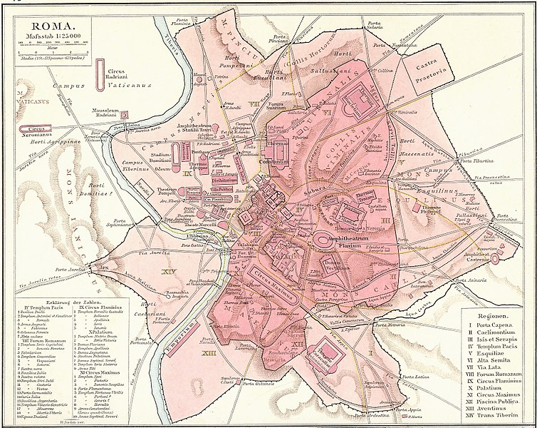
Map of the 14 administrative regions of Augustan Rome.
摘要
[編輯]| 描寫文Roma Plan.jpg |
Deutsch: Plan Roms im Altertum
English: Map of the 14 administrative regions of ancient Rome.
Français : Plan de Rome dans l'Antiquité. Carte issue de l'Allgemeiner Historischer Handatlas de Gustav Droysen dirigé par Richard Andree, 1886. |
|||||||||
| 日期 | ||||||||||
| 來源 | G. Droysen's Allgemeiner Historischer Handatlas | |||||||||
| 創作作者 |
未知Unknown author (H. Jordan ?) |
|||||||||
| 授權許可 (重用此檔案) |
|
|||||||||
| Geotemporal data | ||||||||||
| 邊框 |
|
|||||||||
| 地理參考 | 查看Wikimaps Warper的地理參考圖 | |||||||||
| 其他版本 |
|
|||||||||
On July 26th (pacific time) 2008, I, Amadscientist altered the existing image as part of Project Illustration to improve the current images on Wiki. This is part of improvements to articles on Ancient Rome.
The same member then uploaded the same file but at the original size. for faster loading.--Amadscientist (talk) 06:44, 27 July 2008 (UTC)
| 註解 InfoField | 該圖片含有註解:在維基媒體共享資源上查看註解 |
720
427
34
24
1840
1463
הפנתאון ברומא
檔案歷史
點選日期/時間以檢視該時間的檔案版本。
| 日期/時間 | 縮圖 | 尺寸 | 用戶 | 備註 | |
|---|---|---|---|---|---|
| 目前 | 2015年3月30日 (一) 16:14 |  | 1,840 × 1,463(2.5 MB) | Jonstevn(對話 | 貢獻) | Reverted to version as of 19:01, 28 August 2006 |
| 2015年3月30日 (一) 16:10 |  | 1,840 × 1,463(2.5 MB) | Jonstevn(對話 | 貢獻) | Reverted to version as of 19:01, 28 August 2006 | |
| 2015年3月30日 (一) 16:10 |  | 1,840 × 1,463(2.5 MB) | Jonstevn(對話 | 貢獻) | Reverted to version as of 19:01, 28 August 2006 | |
| 2008年7月27日 (日) 06:40 |  | 1,840 × 1,463(3.38 MB) | Amadscientist(對話 | 貢獻) | {{Information |Description= |Source= |Date= |Author= |Permission= |other_versions= }} | |
| 2008年7月27日 (日) 04:57 |  | 4,000 × 3,180(12.21 MB) | Amadscientist(對話 | 貢獻) | {{Information |Description= |Source= |Date= |Author= |Permission= |other_versions= }} | |
| 2006年8月28日 (一) 19:01 |  | 1,840 × 1,463(2.5 MB) | Nikephoros(對話 | 貢獻) | {{Information |Description=Plan Roms im Altertum / Map of Rome during Antiquity |Source=G. Droysens Allgemeiner Historischer Handatlas |Date=1886 |Author=? |Permission= not needed |other_versions= no }} |
無法覆蓋此檔案。
檔案用途
下列6個頁面有用到此檔案:
全域檔案使用狀況
以下其他 wiki 使用了這個檔案:
- ar.wikipedia.org 的使用狀況
- as.wikipedia.org 的使用狀況
- azb.wikipedia.org 的使用狀況
- beta.wikiversity.org 的使用狀況
- bg.wikipedia.org 的使用狀況
- bn.wikipedia.org 的使用狀況
- bs.wikipedia.org 的使用狀況
- bxr.wikipedia.org 的使用狀況
- ca.wikipedia.org 的使用狀況
- ceb.wikipedia.org 的使用狀況
- cs.wikipedia.org 的使用狀況
- de.wikipedia.org 的使用狀況
- de.wikiversity.org 的使用狀況
- el.wikipedia.org 的使用狀況
檢視此檔案的更多全域使用狀況。
分類:


