File:Roman Antiquities Found at Reculver.jpg

Original file (2,309 × 321 pixels, file size: 133 KB, MIME type: image/jpeg)
Captions
Captions
Summary[edit]
| English: Roman Antiquities found at Reculver
( |
|||||||||||||||||||||||||||
|---|---|---|---|---|---|---|---|---|---|---|---|---|---|---|---|---|---|---|---|---|---|---|---|---|---|---|---|
| Author |
creator QS:P170,Q1610319 |
||||||||||||||||||||||||||
| Title |
English: Roman Antiquities found at Reculver |
||||||||||||||||||||||||||
| Description |
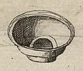
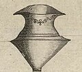
English: A depiction of some Roman objects recovered from the former Roman fort of Regulbium near Reculver from Moll's map of Kent, sold separately and as Map 13 in his Set of Fifty New and Correct Maps of England and Wales... Three objects are labelled as a Strigil Romanae, Legulae Mensalis, and Cochleare Sacrium. The legula and cochlear have their labels mistakenly reversed.
Français : Sujet : Divisions politiques et administratives
Kent, Comté de -- Divisions politiques et administratives Douvres Greenwich Échelle(s) : 8 English Miles [= 4 cm] Référence bibliographique : 173 Appartient à l’ensemble documentaire : AnvilEur Appartient à l’ensemble documentaire : MAEDI008 Appartient à l’ensemble documentaire : MAEDIGen0 Couverture : Royaume-Uni – Angleterre – Kent Langue : anglais |
||||||||||||||||||||||||||
| Date |
1724 date QS:P571,+1724-00-00T00:00:00Z/9 |
||||||||||||||||||||||||||
| Dimensions |
height: 32 cm (12.5 in); width: 23.5 cm (9.2 in) dimensions QS:P2048,32U174728 dimensions QS:P2049,23,5U174728 |
||||||||||||||||||||||||||
| Collection |
institution QS:P195,Q193563 |
||||||||||||||||||||||||||
| References |
Français : Notice de recueil : http://catalogue.bnf.fr/ark:/12148/cb40577015h
Appartient à : Collection d'Anville ; 02066 Notice du catalogue : http://catalogue.bnf.fr/ark:/12148/cb41246716j |
||||||||||||||||||||||||||
| Source/Photographer |
Français : Bibliothèque nationale de France, département Cartes et plans, GE DD-2987 (2066)
Bibliothèque nationale de France |
||||||||||||||||||||||||||
| Permission (Reusing this file) |
|
||||||||||||||||||||||||||
| Other versions |
|
||||||||||||||||||||||||||
| Annotations InfoField | This image is annotated: View the annotations at Commons |
Strigil
Romanae
Legulae Mensalis
Cochleare Sacrium
Roman Antiquities found at Reculver
Roman bowl
Roman urn
Roman bowl
Roman urn
File history
Click on a date/time to view the file as it appeared at that time.
| Date/Time | Thumbnail | Dimensions | User | Comment | |
|---|---|---|---|---|---|
| current | 01:30, 25 June 2023 | 2,309 × 321 (133 KB) | LlywelynII (talk | contribs) | File:Kent - By Herman Moll Geographer - btv1b53056577r.jpg cropped using CropTool. |
You cannot overwrite this file.
File usage on Commons
The following 13 pages use this file:
- User:Adeletron 3030/botgalleries/Sports/2023 June 25-27
- File:Cochleare Sacrium.jpg
- File:Herne Bay Museum 066.jpg
- File:Kent - By Herman Moll Geographer - btv1b53056577r.jpg
- File:Legulae Mensalis.jpg
- File:Roman Antiquities Found at Reculver.jpg
- File:Roman Antiquities Found at Reculver 3.jpg
- File:Roman Pottery Found at Reculver.jpg
- File:Roman Pottery Found at Reculver 2.jpg
- File:Roman Pottery Found at Reculver 4.jpg
- File:Roman Strigil Found at Reculver.jpg
- File:Roman artefacts 011.jpg
- File:Unnamed Figure.jpg


