File:Roman Empire 125 political map-zh.svg
跳至導覽
跳至搜尋

此 SVG 檔案的 PNG 預覽的大小:721 × 599 像素。 其他解析度:289 × 240 像素 | 578 × 480 像素 | 924 × 768 像素 | 1,232 × 1,024 像素 | 2,464 × 2,048 像素 | 2,732 × 2,271 像素。
原始檔案 (SVG 檔案,表面大小:2,732 × 2,271 像素,檔案大小:2.02 MB)
說明
說明
添加單行說明來描述出檔案所代表的內容
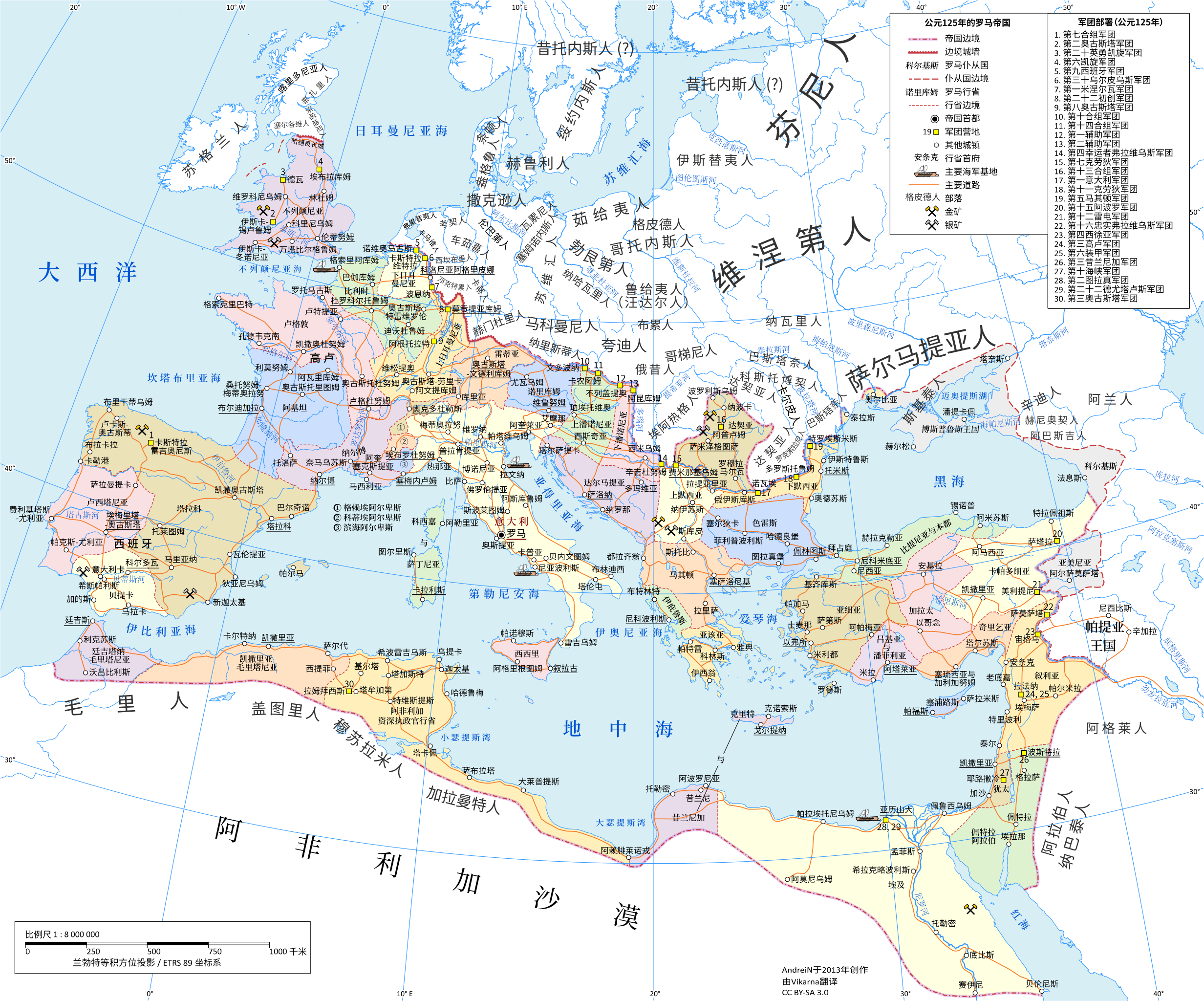
125年罗马帝国
摘要
[編輯]| 描述 |
中文:125年哈德良时期的罗马帝国
|
| 日期 | |
| 來源 |
本檔案衍生自: Roman Empire 125 political map.svg |
| 作者 | Vikarna |
| 其他版本 |
[]
|
| SVG開發 | 本vector image使用Inkscape創作。 |


授權條款
[編輯]
我,本作品的著作權持有者,決定用以下授權條款發佈本作品:
此檔案採用創用CC 姓名標示-相同方式分享 3.0 未在地化版本授權條款。
- 您可以自由:
- 分享 – 複製、發佈和傳播本作品
- 重新修改 – 創作演繹作品
- 惟需遵照下列條件:
- 姓名標示 – 您必須指名出正確的製作者,和提供授權條款的連結,以及表示是否有對內容上做出變更。您可以用任何合理的方式來行動,但不得以任何方式表明授權條款是對您許可或是由您所使用。
- 相同方式分享 – 如果您利用本素材進行再混合、轉換或創作,您必須基於如同原先的相同或兼容的條款,來分布您的貢獻成品。

|
已授權您依據自由軟體基金會發行的無固定段落、封面文字和封底文字GNU自由文件授權條款1.2版或任意後續版本,對本檔進行複製、傳播和/或修改。該協議的副本列在GNU自由文件授權條款中。 |
您可以選擇您需要的授權條款。
檔案歷史
點選日期/時間以檢視該時間的檔案版本。
| 日期/時間 | 縮圖 | 尺寸 | 使用者 | 備註 | |
|---|---|---|---|---|---|
| 目前 | 2024年3月7日 (四) 12:40 | | 2,732 × 2,271(2.02 MB) | Vikarna(留言 | 貢獻) | caledonni→咯里多尼亚人 |
| 2021年2月18日 (四) 09:40 |  | 2,732 × 2,271(1.88 MB) | Vikarna(留言 | 貢獻) | fix | |
| 2021年1月24日 (日) 14:13 |  | 2,732 × 2,271(1.88 MB) | Vikarna(留言 | 貢獻) | Reverted to version as of 14:02, 9 January 2021 (UTC) The render is horrible | |
| 2021年1月24日 (日) 14:12 |  | 2,186 × 1,817(3.3 MB) | Vikarna(留言 | 貢獻) | Test (Use Text → Convert to Text of Inkscape) | |
| 2021年1月9日 (六) 14:02 |  | 2,732 × 2,271(1.88 MB) | Vikarna(留言 | 貢獻) | adjust | |
| 2020年12月30日 (三) 03:25 |  | 2,732 × 2,271(1.89 MB) | Vikarna(留言 | 貢獻) | adjust | |
| 2020年12月29日 (二) 14:49 |  | 2,732 × 2,271(1.89 MB) | Vikarna(留言 | 貢獻) | fix | |
| 2020年12月29日 (二) 12:41 |  | 2,732 × 2,271(1.95 MB) | Vikarna(留言 | 貢獻) | fix | |
| 2020年12月29日 (二) 12:36 |  | 2,732 × 2,271(1.95 MB) | Vikarna(留言 | 貢獻) | one more | |
| 2020年12月29日 (二) 12:11 |  | 2,732 × 2,271(1.95 MB) | Vikarna(留言 | 貢獻) | fix |
無法覆蓋此檔案。
檔案用途
下列28個頁面有用到此檔案:
- User:Chumwa/OgreBot/Transport Maps/2020 December 21-31
- User:Chumwa/OgreBot/Transport Maps/2021 February 10-18
- User:Chumwa/OgreBot/Transport Maps/2021 January 1-10
- User:Chumwa/OgreBot/Transport Maps/2021 January 21-31
- User:Chumwa/OgreBot/Transport Maps/2024 March 1-10
- User:Chumwa/OgreBot/Travel and communication maps/2020 December 21-31
- User:Chumwa/OgreBot/Travel and communication maps/2021 February 10-18
- User:Chumwa/OgreBot/Travel and communication maps/2021 January 1-10
- User:Chumwa/OgreBot/Travel and communication maps/2021 January 21-31
- User:Chumwa/OgreBot/Travel and communication maps/2024 March 1-10
- User:Magog the Ogre/Multilingual legend/2020 December 21-31
- User:Magog the Ogre/Multilingual legend/2021 February 10-18
- User:Magog the Ogre/Multilingual legend/2021 January 1-10
- User:Magog the Ogre/Multilingual legend/2021 January 21-31
- User:Magog the Ogre/Multilingual legend/2024 March 5-8
- Commons:Graphic Lab/Map workshop/Archive/2021
- File:Roman Empire 125.png
- File:Roman Empire 125 general map-zh.png
- File:Roman Empire 125 general map-zh.svg
- File:Roman Empire 125 general map.SVG
- File:Roman Empire 125 general map pl.svg
- File:Roman Empire 125 political map-de.svg
- File:Roman Empire 125 political map-zh.png
- File:Roman Empire 125 political map-zh.svg
- File:Roman Empire 125 political map.png
- File:Roman Empire 125 political map.svg
- File:Roman Empire 125 political map pl.svg
- Template:Other versions/Roman Empire 125 map
全域檔案使用狀況
以下其他 wiki 使用了這個檔案:
- zh.wikipedia.org 的使用狀況
詮釋資料
分類:
- Chinese-language SVG maps showing history
- 125 in Europe
- Administrative maps of the Roman Empire
- Bastarnae
- Burgundians
- Carpi people
- Costoboci
- Hasdingi
- Historical maps of the Carpathian Mountains
- Iazyges
- Maps of Dacian tribes
- Maps of Roman Dacia
- Maps of ancient Roman roads
- Maps of the European Antiquity
- Maps of the Gepids
- Maps of the Goths
- Maps of the Roman Empire in 125 AD
- Maps of the Rugii
- Maps of the Vandals
- Maps of the history of Romania in ancient times
- Marcomanni
- Oksywie culture
- Poland in the 1st century
- Poland in the 2nd century
- Pomerania in the 1st century
- Pomerania in the 2nd century
- Quadi
- Maps of the Scythians
- Silingi
- Wielbark culture maps
- Maps created in 2020