File:Rota do âmbar.jpg
Jump to navigation
Jump to search
No higher resolution available.
Rota_do_âmbar.jpg (411 × 599 pixels, file size: 69 KB, MIME type: image/jpeg)
Captions
Captions
Add a one-line explanation of what this file represents

|
This map image could be re-created using vector graphics as an SVG file. This has several advantages; see Commons:Media for cleanup for more information. If an SVG form of this image is available, please upload it and afterwards replace this template with
{{vector version available|new image name}}.
It is recommended to name the SVG file “Rota do âmbar.svg”—then the template Vector version available (or Vva) does not need the new image name parameter. |


Summary[edit]
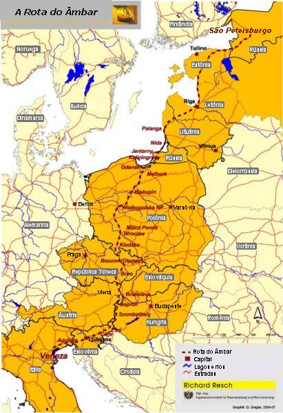
Amber Road on the map of Europe. Source: Map of the Amber Road in Portuguese. PD map taken from de:Bild:Bernsteinstrasse.jpg and modified by me. Uploaded by: User:Bonas
Licensing[edit]
| I, the copyright holder of this work, release this work into the public domain. This applies worldwide. In some countries this may not be legally possible; if so: I grant anyone the right to use this work for any purpose, without any conditions, unless such conditions are required by law. |
File history
Click on a date/time to view the file as it appeared at that time.
| Date/Time | Thumbnail | Dimensions | User | Comment | |
|---|---|---|---|---|---|
| current | 03:41, 27 August 2006 | | 411 × 599 (69 KB) | Bonas (talk | contribs) | Amber Road on the map of Europe. Source: Map of the Amber Road in Portuguese. PD map taken from de:Bild:Bernsteinstrasse.jpg and modified by me. Uploaded by: User:Bonas Amber Road [[Category:O |
You cannot overwrite this file.
File usage on Commons
The following page uses this file:
File usage on other wikis
The following other wikis use this file:
- Usage on an.wikipedia.org
- Usage on be.wikipedia.org
- Usage on da.wikipedia.org
- Usage on eo.wikipedia.org
- Usage on es.wikipedia.org
- Usage on et.wikipedia.org
- Usage on hr.wikipedia.org
- Usage on it.wikivoyage.org
- Usage on ko.wikipedia.org
- Usage on la.wikipedia.org
- Usage on mk.wikipedia.org
- Usage on pl.wikipedia.org
- Usage on pt.wikipedia.org
- Usage on sh.wikipedia.org
- Usage on sk.wikipedia.org
- Usage on sr.wikipedia.org
- Usage on sv.wikipedia.org
- Usage on th.wikipedia.org
- Usage on uk.wikipedia.org
- Соляний шлях (Україна)
- Шлях із варягів у греки
- Бурштин
- Ганза
- Великий шовковий шлях
- Манільські галеони
- Римські дороги
- Трикутникова торгівля
- Сибірський тракт
- Бурштиновий шлях
- Соляний шлях
- Шаблон:Історичні торговельні шляхи
- Via Maris
- Via Regia (Азія)
- Шлях пахощів
- Дорога спецій
- Великий колісний шлях
- Дороги інків
- Олов'яний шлях
- Волзький торговий шлях
- Індо-римська торгівля
- Царська дорога Персії
- Via Regia (Європа)
- Транссахарська торгівля
View more global usage of this file.