File:Rough Section of Persia from Enselle on Caspian through Kasvin Teheran, Shiraz to Bushire on Persian Gulf.jpg
From Wikimedia Commons, the free media repository
Jump to navigation
Jump to search

Size of this preview: 515 × 600 pixels. Other resolutions: 206 × 240 pixels | 412 × 480 pixels | 659 × 768 pixels | 879 × 1,024 pixels | 1,758 × 2,048 pixels | 2,576 × 3,000 pixels.
Original file (2,576 × 3,000 pixels, file size: 974 KB, MIME type: image/jpeg)
File information
Structured data
Captions
Captions
Add a one-line explanation of what this file represents
| DescriptionRough Section of Persia from Enselle on Caspian through Kasvin Teheran, Shiraz to Bushire on Persian Gulf.jpg |
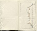
English: Plan marked paper no. 7C, indicating the height above sea level (expressed in feet) of the route taken from Enselle [Bandar-e Anzalī] near Rasht, to Bushire, via Kasvin [Qazvin], Teheran [Tehran] and Shiraz, by Colonel Augustus Le Messurier of the Bombay Engineers, in 1887. The section is drawn as a solid black and red line, with the Caspian Sea on the left side of the plan, and the Persian Gulf on the right side. Towns and cities along the route are marked on the section. Significant mountains (for example, Demavend [Kūh-e Damāvand]) are also marked on the route.
The plan bears a printed signature (illegible) in the bottom right corner, dated 28 November 1887. Under the plan is the statement: ‘Photozincographed at the Survey of India Office , Calcutta, March 1888. |
||||
| Date | |||||
| Source | https://www.qdl.qa/en/archive/81055/vdc_100048990082.0x00001d | ||||
| Author | East India Company, the Board of Control, the India Office, or other British Government Department | ||||
| Permission (Reusing this file) |
|
File history
Click on a date/time to view the file as it appeared at that time.
| Date/Time | Thumbnail | Dimensions | User | Comment | |
|---|---|---|---|---|---|
| current | 18:03, 6 January 2019 |  | 2,576 × 3,000 (974 KB) | SteinsplitterBot (talk | contribs) | Bot: Image rotated by 90° |
| 16:27, 6 January 2019 |  | 3,000 × 2,580 (976 KB) | Hanooz (talk | contribs) | complete | |
| 16:25, 6 January 2019 |  | 3,000 × 2,580 (216 KB) | Hanooz (talk | contribs) | Transferred from https://images.qdl.qa/iiif/images/81055/vdc_100000000912.0x00003d/IOR_L_PS_20_125_0047.jp2/full/4800,/0/default.jpg |
You cannot overwrite this file.
File usage on Commons
There are no pages that use this file.
Metadata
This file contains additional information such as Exif metadata which may have been added by the digital camera, scanner, or software program used to create or digitize it. If the file has been modified from its original state, some details such as the timestamp may not fully reflect those of the original file. The timestamp is only as accurate as the clock in the camera, and it may be completely wrong.
| JPEG file comment | Generated by IIPImage |
|---|
Hidden category:
