File:Roy 1777 Triangulation of Snowdon and Moel Eilio 00907249 0159-0164.jpg
Jump to navigation
Jump to search

Size of this preview: 764 × 599 pixels. Other resolutions: 306 × 240 pixels | 612 × 480 pixels | 979 × 768 pixels | 1,280 × 1,004 pixels | 2,560 × 2,009 pixels | 9,410 × 7,383 pixels.
Original file (9,410 × 7,383 pixels, file size: 26.6 MB, MIME type: image/jpeg)
Captions
Captions
Triangulation of Snowdon and Moel Eilio
Summary[edit]
| Description |
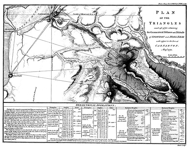
English: Plan of the triangles made use of for obtaining the geometrical distance and altitude of snowdon and Moel Eilio with respect to the sea at Carnarvon (Caernarfon). From: Roy, William (1777). "Experiments and observations made in Britain, in order to obtain a rule for measuring heights with the barometer". Philosophical Transactions of the Royal Society of London 67: 653-787. |
|||||||||
| Date | ||||||||||
| Source | https://archive.org/details/philtrans00907249 | |||||||||
| Creator |
Roy, W. (William) 1726-1790 |
|||||||||
| Geotemporal data | ||||||||||
| Bounding box |
|
|||||||||
| Georeferencing | ||||||||||
Licensing[edit]
|
This work is in the public domain in its country of origin and other countries and areas where the copyright term is the author's life plus 70 years or fewer. This work is in the public domain in the United States because it was published (or registered with the U.S. Copyright Office) before January 1, 1929. | |
| This file has been identified as being free of known restrictions under copyright law, including all related and neighboring rights. | |
File history
Click on a date/time to view the file as it appeared at that time.
| Date/Time | Thumbnail | Dimensions | User | Comment | |
|---|---|---|---|---|---|
| current | 10:42, 1 June 2023 | | 9,410 × 7,383 (26.6 MB) | Kognos (talk | contribs) | Uploaded a work by Roy, W. (William) 1726-1790 from https://archive.org/details/philtrans00907249 with UploadWizard |
You cannot overwrite this file.
File usage on Commons
There are no pages that use this file.