File:Royal Air Force Bomber Command, 1942-1945. CL3400.jpg
跳至導覽
跳至搜尋

預覽大小:725 × 599 像素。 其他解析度:290 × 240 像素 | 581 × 480 像素 | 929 × 768 像素 | 1,238 × 1,024 像素 | 2,143 × 1,772 像素。
原始檔案 (2,143 × 1,772 像素,檔案大小:1.56 MB,MIME 類型:image/jpeg)
說明
說明
添加單行說明來描述出檔案所代表的內容
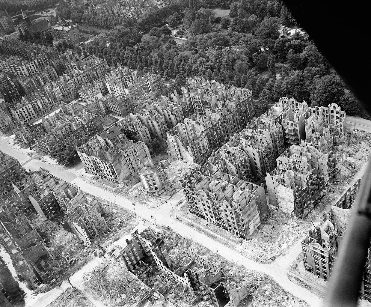
Destroyed buildings after the Allied bombing of Hamburg during World War II.
摘要
[編輯]| 作家 |
Dowd J (Fg Off), Royal Air Force official photographer |
|||
| 描述 |
Deutsch: Blick von Südosten nach Nordwesten über beim durch britische Bomben ausgelösten Feuersturm 27./28. Juli 1943 ausgebrannte Wohnhäuser: Die Hauptstraße im Bild ist der Eilbeker Weg, die Querstraßen, rechts beginnend, Kleiststraße, Rückertstraße (südl. des Eilbeker Wegs ist eine Sperrmauer zu sehen, die die zerstörte und daher unbewohnte Feuersturmzone abriegelt), Seumestraße (mit Haus Seumestr. Nr. 44 auf der östlichen Straßenseite, einziges unzerstörtes Haus im sichtbaren Abschnitt der Straße, bis heute erhalten), Wielandstraße, Friedrichsberger Straße, in diese mündet per T-Kreuzung die Auenstraße. Am oberen Bildrand verläuft die Straße Eilbektal, darin blieben erhalten (soweit zu sehen) die Versöhnungskirche (im Bild im linken oberen Eck) und rechts davon die ehemalige Volksschule Eilbektal auf der nördlichen Straßenseite (im Bild oben links, heute: Berufliche Schule für KFZ-Technik), und auf südlicher Straßenseite das Haus Eilbektal Nr. 60 (bis heute erhalten, zw. Wieland- und Friedrichsberger Str.). Ansonsten erstreckt sich auf der Nordseite der Straße Eilbektal der Eilbekpark und der Friedrichsberger Park.
Español: Vista de sureste a noroeste sobre la tormenta de fuego provocada por las bombas británicas el 27/28 de julio de 1943. Edificios residenciales quemados en julio de 1943: la calle principal en la imagen es Eilbeker Weg, las calles transversales, comenzando a la derecha, Kleiststraße, Rückertstraße (al sur de Eilbeker Weg se puede ver un muro de barrera que sella el fuego destruido y, por lo tanto, deshabitado zona de tormentas), Seumestraße (con la casa Seumestr No. 44 en el lado este de la calle, la única casa intacta en la sección visible de la calle, conservada hasta el día de hoy), Wielandstraße, Friedrichsberger Straße, a la que conduce Auenstraße a través de una T -unión. La calle Eilbektal corre a lo largo del borde superior de la imagen, en la que se encuentra la Iglesia de la Reconciliación (en la imagen en la esquina superior izquierda) y a su derecha la antigua escuela primaria Eilbectal en el lado norte de la calle (en la imagen de arriba a la izquierda, hoy: Escuela Vocacional de Vehículos Motorizados) (hasta donde se puede ver) Technik), y en el lado sur de la calle la casa Eilbektal No. 60 (conservada hasta el día de hoy, entre Wielandstrasse y Friedrichsberger Strasse). En otros lugares, el Eilbekpark y el Friedrichsberger Park se extienden en el lado norte de la calle Eilbektal.
English: Royal Air Force Bomber Command, 1942-1945. Oblique aerial view of ruined residential and commercial buildings south of the Eilbektal Park (seen at upper right) in the Eilbek district of Hamburg, Germany. These were among the 16,000 multi-storeyed apartment buildings destroyed by the firestorm which developed during the raid by Bomber Command on the night of 27/28 July 1943 (Operation GOMORRAH). The road running diagonally from upper left to lower right is Eilbeker Weg, crossed by Rückertstraße. |
|||
| 日期 | Probably between VE day and mid 1946 | |||
| 來源/攝影者 |
https://www.iwm.org.uk/collections/item/object/205023601
|
|||
| 授權許可 (重用此檔案) |
This image was created and released by the Imperial War Museum on the IWM Non Commercial Licence. Photographs taken, or artworks created, by a member of the forces during their active service duties are covered by Crown Copyright provisions. Faithful reproductions may be reused under that licence. | |||
| 其他版本 | ||||
| Part of | Air Ministry Second World War Official Collection | |||
| Subjects |
|
|||
| Category | photographs | |||
| Image Sorted | yes |

.jpg)
| 拍攝地點 | | 位於此地的本圖片與其他圖片: OpenStreetMap |
|---|
|
授權條款
[編輯]本影像屬於公有領域,因為該影像是單純針對一件公有領域原作進行機械掃描,或(從現有證據來看)類似掃描而來的,或該重製照片可以預期不會有版權保護。原作屬於公有領域,是因下述原因:
本標籤主要用於該掃描件有可能使用任何增強功能(如亮度、對比度、色彩調整、銳利化等),而這些增強功能無法達到原創性而無法產生版權的情形下使用。而該標籤也能使用在無法判定本掃描件使用任何增強功能,以及已知使用增強功能但沒有充分證據時。對於採取原始忠實掃描而不使用增強功能的照片,可以適當採用{{PD-old}}標籤取代。對於本標籤的使用方法,參見如何使用PD-Scan標籤。  |

| 註解 | 該圖片含有註解:在維基媒體共享資源上查看註解 |
檔案歷史
點選日期/時間以檢視該時間的檔案版本。
| 日期/時間 | 縮圖 | 尺寸 | 用戶 | 備註 | |
|---|---|---|---|---|---|
| 目前 | 2017年10月5日 (四) 02:56 | | 2,143 × 1,772(1.56 MB) | Ducksoup(對話 | 貢獻) | Resolution 800×661, replace with 2,143×1,772 |
| 2013年2月5日 (二) 13:22 |  | 800 × 661(139 KB) | Fæ(對話 | 貢獻) | {{Information |description = {{en|''Royal Air Force Bomber Command, 1942-1945.''<br/> Oblique aerial view of ruined residential and commercial buildings south of the Stadtpark (seen at upper right) in the Eilbek district of Hamburg, Germany. These wer... |
無法覆蓋此檔案。
檔案用途
下列4個頁面有用到此檔案:
全域檔案使用狀況
以下其他 wiki 使用了這個檔案:
- af.wikipedia.org 的使用狀況
- ar.wikipedia.org 的使用狀況
- arz.wikipedia.org 的使用狀況
- ast.wikipedia.org 的使用狀況
- bg.wikipedia.org 的使用狀況
- bn.wikipedia.org 的使用狀況
- ca.wikipedia.org 的使用狀況
- co.wikipedia.org 的使用狀況
- cs.wikipedia.org 的使用狀況
- da.wikipedia.org 的使用狀況
- de.wikipedia.org 的使用狀況
- Zweiter Weltkrieg
- 28. Juli
- Wolfgang Borchert
- Hamburg-Eilbek
- Geschichte Hamburgs
- Operation Gomorrha
- Humanitäres Völkerrecht
- Max Brauer
- Hamburg in der Zeit des Nationalsozialismus
- 1943
- Benutzer:Bdf/Weltkrieg
- Liste von Luftangriffen der Alliierten auf das Deutsche Reich (1939–1945)
- Versöhnungskirche (Hamburg-Eilbek)
- Wikipedia:Auskunft/Archiv/2021/Woche 06
- de.wikiversity.org 的使用狀況
- el.wikipedia.org 的使用狀況
- en.wikipedia.org 的使用狀況
檢視此檔案的更多全域使用狀況。
分類:
- Versöhnungskirche (Hamburg-Eilbek)
- Eilbektal
- Eilbeker Weg
- Kleiststraße (Hamburg)
- Rückertstraße (Hamburg)
- Seumestraße (Hamburg)
- Wielandstraße (Hamburg)
- Friedrichsberger Straße (Hamburg)
- World War II aerial photographs of Hamburg
- Bombing of Hamburg in World War II
- Demolished buildings in Hamburg
- World War II bombing damage in Germany
- Royal Air Force Bomber Command, 1942–1945
- 1943 in Hamburg
- Operation Gomorrha
- Bomb craters from World War II in Germany
- Air Ministry Second World War Official Collection
- Schule Eilbektal