File:Rubihorn06.jpg
Jump to navigation
Jump to search

Size of this preview: 800 × 588 pixels. Other resolutions: 320 × 235 pixels | 640 × 470 pixels | 1,024 × 753 pixels | 1,280 × 941 pixels | 2,196 × 1,614 pixels.
Original file (2,196 × 1,614 pixels, file size: 3.48 MB, MIME type: image/jpeg)
Captions
Captions
Add a one-line explanation of what this file represents
Summary
[edit]
| Description |
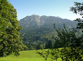
Deutsch: Das Rubihorn ist ein 1957 Meter hoher Berg in den Allgäuer Alpen und liegt östlich von Oberstdorf in Bayern, Deutschland. Im Bild: Blick auf das Rubihorn vom Ufer der Trettach aus.
English: View to the mountain Rubihorn east of Oberstdorf, Bavaria, Germany. |
| Date | |
| Source | Own work |
| Author | Nikater |
| Permission (Reusing this file) |
Own work, all rights released (Public domain) |
| Camera location | | View this and other nearby images on: OpenStreetMap |
|---|
Licensing
[edit]
| I, the copyright holder of this work, release this work into the public domain. This applies worldwide. In some countries this may not be legally possible; if so: I grant anyone the right to use this work for any purpose, without any conditions, unless such conditions are required by law. |
| Annotations | This image is annotated: View the annotations at Commons |
File history
Click on a date/time to view the file as it appeared at that time.
| Date/Time | Thumbnail | Dimensions | User | Comment | |
|---|---|---|---|---|---|
| current | 15:54, 11 September 2011 | | 2,196 × 1,614 (3.48 MB) | Nikater (talk | contribs) | {{Information |Description= {{de|Das Rubihorn ist ein 1957 Meter hoher Berg in den Allgäuer Alpen und liegt östlich von Oberstdorf in Bayern, Deutschland. Im Bild: Blick auf das Rubihorn vom Uf |
You cannot overwrite this file.
File usage on Commons
There are no pages that use this file.