File:Ruimtelijkemodellering klein.png
Jump to navigation
Jump to search
No higher resolution available.
Ruimtelijkemodellering_klein.png (616 × 419 pixels, file size: 8 KB, MIME type: image/png)
Captions
Captions
Add a one-line explanation of what this file represents
Summary[edit]
| Description |
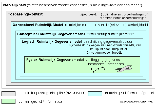
Nederlands: Zelfgemaakte media. Gedeeltelijk op basis van input van theorie uit 'Geografische Informatie Systemen in ruimtelijke onderzoek' (P. Hendriks & Henk Ottens, Van Gorcum & Comp B.V. Assen, 1997) is dit schema opgsteld. Het beschrijft de relatie tussen verschillende logische, conceptuele en gegevensmodellen. |
| Date | 4 May 2007 (original upload date) |
| Source | Transfered from nl.wikipedia |
| Author | Original uploader was TjeerdN at nl.wikipedia |
| Permission (Reusing this file) |
Licensed under the GFDL by the author; Released under the GNU Free Documentation License. |
Licensing[edit]

|
Permission is granted to copy, distribute and/or modify this document under the terms of the GNU Free Documentation License, Version 1.2 or any later version published by the Free Software Foundation; with no Invariant Sections, no Front-Cover Texts, and no Back-Cover Texts. A copy of the license is included in the section entitled GNU Free Documentation License. |
| This file is licensed under the Creative Commons Attribution-Share Alike 3.0 Unported license. | ||
| Attribution: TjeerdN | ||
| ||
| This licensing tag was added to this file as part of the GFDL licensing update. |
Original upload log[edit]
The original description page was here. All following user names refer to nl.wikipedia.
- 2007-05-04 09:27 TjeerdN 616×419×8 (8421 bytes) Zelfgemaakte media. Gedeeltelijk op basis van input van theorie uit 'Geografische Informatie Systemen in ruimtelijke onderzoek' (P. Hendriks & Henk Ottens, Van Gorcum & Comp B.V. Assen, 1997) is dit schema opgsteld. Het beschrijft de relatie tussen versch
File history
Click on a date/time to view the file as it appeared at that time.
| Date/Time | Thumbnail | Dimensions | User | Comment | |
|---|---|---|---|---|---|
| current | 22:21, 29 November 2007 | | 616 × 419 (8 KB) | BotMultichill (talk | contribs) | {{BotMoveToCommons|nl.wikipedia}} {{Information |Description={{nl|Zelfgemaakte media. Gedeeltelijk op basis van input van theorie uit 'Geografische Informatie Systemen in ruimtelijke onderzoek' (P. Hendriks & Henk Ottens, Van Gorcum & Comp B.V. Assen, 1 |
You cannot overwrite this file.
File usage on Commons
There are no pages that use this file.
File usage on other wikis
The following other wikis use this file:
- Usage on nl.wikipedia.org
- Usage on nl.wikibooks.org