File:São Tomé and Príncipe location map.svg
Salta a la navegació
Salta a la cerca

Mida d'aquesta previsualització PNG del fitxer SVG: 428 × 599 píxels. Altres resolucions: 171 × 240 píxels | 343 × 480 píxels | 549 × 768 píxels | 732 × 1.024 píxels | 1.464 × 2.048 píxels | 496 × 694 píxels.
Fitxer original (fitxer SVG, nominalment 496 × 694 píxels, mida del fitxer: 10 Ko)
Llegendes
Llegendes
Afegeix una explicació d'una línia del que representa aquest fitxer
Resum[modifica]
| Descripció |
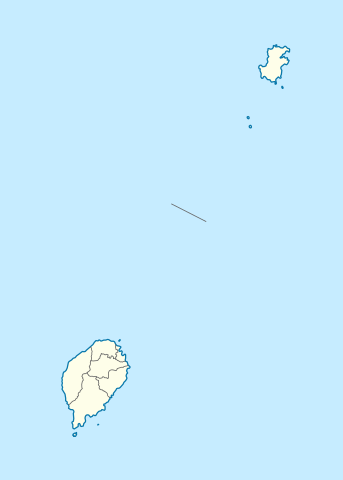
Deutsch: Positionskarte von São Tomé and Príncipe
Quadratische Plattkarte. Geographische Begrenzung der Karte:
English: Location map of São Tomé and Príncipe
Equirectangular projection. Geographic limits of the map:
|
| Data | |
| Font |
Treball propi, using
|
| Autor | NordNordWest |
| Permís (Com reutilitzar aquest fitxer) |
Jo, el titular dels drets d'autor d'aquest treball, el public sota la següent llicència: Aquest fitxer està subjecte a la llicència de Creative Commons Reconeixement i Compartir Igual 3.0 No adaptada.
|

|
This map has been made or improved in the German Kartenwerkstatt (Map Lab). You can propose maps to improve as well.
|
Historial del fitxer
Cliqueu una data/hora per veure el fitxer tal com era aleshores.
| Data/hora | Miniatura | Dimensions | Usuari/a | Comentari | |
|---|---|---|---|---|---|
| actual | 19:01, 27 nov 2020 | | 496 × 694 (10 Ko) | NordNordWest (discussió | contribucions) | more exact |
| 15:25, 17 juny 2014 |  | 496 × 694 (9 Ko) | NordNordWest (discussió | contribucions) | corr | |
| 19:40, 5 oct 2009 |  | 496 × 694 (13 Ko) | NordNordWest (discussió | contribucions) | {{int:filedesc}} {{Information |Description= {{de|Positionskarte von São Tomé and Príncipe}} Quadratische Plattkarte. Geographische Begrenzung der Karte: * N: 1.9° N * S: 0.2° S * W: 6.2° E * O: 7.7° E {{en|Location |
No podeu sobreescriure aquest fitxer.
Ús del fitxer
Les 9 pàgines següents utilitzen aquest fitxer:
- User:NordNordWest/Gallery/Location maps
- File:COVID-19 Outbreak in São Tomé and Príncipe by islands.svg
- File:São Tomé and Príncipe - Cantagalo.svg
- File:São Tomé and Príncipe - Caué.svg
- File:São Tomé and Príncipe - Lembá.svg
- File:São Tomé and Príncipe - Lobata.svg
- File:São Tomé and Príncipe - Mé-Zóchi.svg
- File:São Tomé and Príncipe - Pagué.svg
- File:São Tomé and Príncipe - Água Grande.svg
Ús global del fitxer
Utilització d'aquest fitxer en altres wikis:
- Utilització a af.wikipedia.org
- Utilització a am.wikipedia.org
- Utilització a an.wikipedia.org
- Utilització a ar.wikipedia.org
- Utilització a ast.wikipedia.org
- Utilització a ba.wikipedia.org
- Utilització a be-tarask.wikipedia.org
- Utilització a be.wikipedia.org
- Utilització a bg.wikipedia.org
- Utilització a bn.wikipedia.org
- Utilització a bs.wikipedia.org
- Utilització a ca.wikipedia.org
- Utilització a ceb.wikipedia.org
Vegeu més usos globals d'aquest fitxer.