File:Südtirol mit Martelltal.png
Jump to navigation
Jump to search

Size of this preview: 800 × 531 pixels. Other resolutions: 320 × 212 pixels | 640 × 424 pixels | 852 × 565 pixels.
Original file (852 × 565 pixels, file size: 1.03 MB, MIME type: image/png)
Captions
Captions
Add a one-line explanation of what this file represents
Summary
[edit]
| Description | |
| Date | (UTC) |
| Source | |
| Author |
|
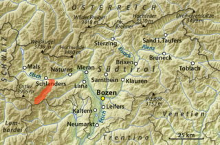
| This is a retouched picture, which means that it has been digitally altered from its original version. Modifications: Markierung des Martelltals. The original can be viewed here: Übersichtskarte Südtirol.png:
|
Licensing
[edit]
I, the copyright holder of this work, hereby publish it under the following licenses:
| This file is licensed under the Creative Commons Attribution-Share Alike 3.0 Unported license. | ||
| ||
| This licensing tag was added to this file as part of the GFDL licensing update. |

|
Permission is granted to copy, distribute and/or modify this document under the terms of the GNU Free Documentation License, Version 1.2 or any later version published by the Free Software Foundation; with no Invariant Sections, no Front-Cover Texts, and no Back-Cover Texts. A copy of the license is included in the section entitled GNU Free Documentation License. |
You may select the license of your choice.
The map has been created with the Generic Mapping Tools: https://www.generic-mapping-tools.org/ using one or more of these public-domain datasets for the relief:
|
|
|
Permission is granted to copy, distribute and/or modify this document under the terms of the GNU Free Documentation License, Version 1.2 or any later version published by the Free Software Foundation; with no Invariant Sections, no Front-Cover Texts, and no Back-Cover Texts. A copy of the license is included in the section entitled GNU Free Documentation License. |
Original upload log
[edit]
This image is a derivative work of the following images:
- File:Übersichtskarte_Südtirol.png licensed with Cc-by-sa-3.0-migrated, GFDL-GMT
- 2009-06-09T16:28:22Z NordNordWest 862x571 (1009398 Bytes) c
- 2009-06-09T12:58:01Z NordNordWest 862x571 (1008916 Bytes) c
- 2009-06-09T12:52:19Z NordNordWest 862x571 (1008909 Bytes) {{Information |Description= {{de|Übersichtskarte von [[:de:Südtirol|Südtirol]], [[:de:Italien|Italien]]}} {{en|General map of the [[:en:Province of Bolzano-Bozen|Province of Bolzano-Bozen]], [[:en:Italy|Italy]]}} |Source=o
Uploaded with derivativeFX
File history
Click on a date/time to view the file as it appeared at that time.
| Date/Time | Thumbnail | Dimensions | User | Comment | |
|---|---|---|---|---|---|
| current | 14:54, 11 September 2011 | | 852 × 565 (1.03 MB) | Rupert Pupkin (talk | contribs) | {{Information |Description={{de|Lage des Martelltals in der Übersichtskarte von Südtirol, Italien}} {{en|Location of Martellvalley in the general map of the [[:en:Province of Bolzano-Bozen|Province of |
You cannot overwrite this file.
File usage on Commons
There are no pages that use this file.
File usage on other wikis
The following other wikis use this file:
- Usage on de.wikipedia.org
- Usage on ru.wikipedia.org