File:SAR Kilauea.jpg

Original file (1,000 × 1,000 pixels, file size: 333 KB, MIME type: image/jpeg)
Captions
Captions
| Description | PIA01763: Space Radar Image of Kilauea, Hawaii - interferometry 1 |
| Date | |
| Source | http://photojournal.jpl.nasa.gov/catalog/PIA01763 |
| Author | JPL |
| Permission (Reusing this file) |
Courtesy NASA/JPL-Caltech, http://www.jpl.nasa.gov/images/policy/ |
| This file is in the public domain in the United States because it was solely created by NASA. NASA copyright policy states that "NASA material is not protected by copyright unless noted". (See Template:PD-USGov, NASA copyright policy page or JPL Image Use Policy.) | ||
 |
Warnings:
|
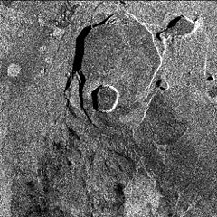
Original Caption Released with Image: Data acquired on April 13, 1994 and on October 4, 1994 from the X-band Synthetic Aperture Radar on board the space shuttle Endeavour were used to generate interferometric fringes, which were overlaid on the X-SAR image of Kilauea. The volcano is centered in this image at 19.58 degrees north latitude and 155.55 degrees west longitude. The image covers about 9 kilometers by 13 kilometers (5.6 miles by 8 miles). The X-band fringes correspond clearly to the expected topographic image. The yellow line indicates the area below which was used for the three-dimensional image using altitude lines. The yellow rectangular frame fences the area for the final topographic image.
Spaceborne Imaging Radar-C and X-band Synthetic Aperture Radar (SIR-C/X-SAR) is part of NASA's Mission to Planet Earth. The radars illuminate Earth with microwaves, allowing detailed observations at any time, regardless of weather or sunlight conditions. SIR-C/X-SAR uses three microwave wavelengths: L-band (24 cm), C-band (6 cm) and X-band (3 cm). The multi-frequency data will be used by the international scientific community to better understand the global environment and how it is changing. The SIR-C/X-SAR data, complemented by aircraft and ground studies, will give scientists clearer insights into those environmental changes which are caused by nature and those changes which are induced by human activity.
SIR-C was developed by NASA's Jet Propulsion Laboratory. X-SAR was developed by the Dornier and Alenia Spazio companies for the German space agency, Deutsche Agentur fuer Raumfahrtangelegenheiten (DARA), and the Italian space agency, Agenzia Spaziale Italiana (ASI), with the Deutsche Forschungsanstalt fuer Luft und Raumfahrt e.V.(DLR), the major partner in science, operations and data processing of X-SAR. The Instituto Ricerca Elettromagnetismo Componenti Elettronici (IRECE) at the University of Naples was a partner in interferometry analysis.
| Annotations | This image is annotated: View the annotations at Commons |
File history
Click on a date/time to view the file as it appeared at that time.
| Date/Time | Thumbnail | Dimensions | User | Comment | |
|---|---|---|---|---|---|
| current | 10:50, 30 March 2007 | | 1,000 × 1,000 (333 KB) | Eve Hall~commonswiki (talk | contribs) | {{Information |Description=PIA01763: Space Radar Image of Kilauea, Hawaii - interferometry 1 |Source=http://photojournal.jpl.nasa.gov/catalog/PIA01763 |Date=1999-05-01 |Author=JPL |Permission=Courtesy NASA/JPL-Caltech, http://www.jpl.nasa.gov/images/polic |
You cannot overwrite this file.
File usage on Commons
The following 2 pages use this file:
File usage on other wikis
The following other wikis use this file:
- Usage on en.wikipedia.org
- Usage on es.wikipedia.org
- Usage on et.wikipedia.org
- Usage on uk.wikipedia.org
- Usage on zh.wikipedia.org