File:SEUtahStrat.JPG
跳转到导航
跳转到搜索

本预览的尺寸:800 × 454像素。 其他分辨率:320 × 182像素 | 640 × 363像素 | 1,024 × 581像素 | 1,280 × 726像素 | 3,161 × 1,794像素。
原始文件 (3,161 × 1,794像素,文件大小:2.5 MB,MIME类型:image/jpeg)
说明
说明
添加一行文字以描述该文件所表现的内容
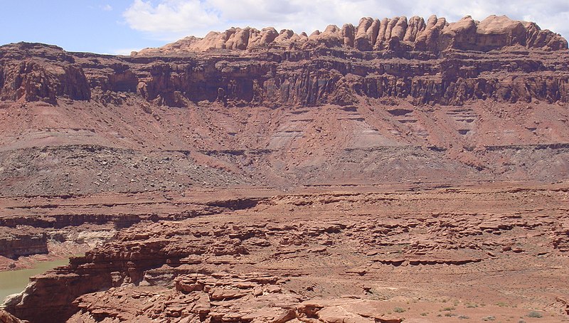
The Permian (bottom) through Jurassic (top) stratigraphy of the Colorado Plateau area of southeastern Utah.
摘要
[编辑]
| 描述 |
English: The Permian (bottom) through Jurassic (top) stratigraphy of the Colorado Plateau area of southeastern Utah that makes up much of the famous prominent rock formations in protected areas such as Capitol Reef National Park and Canyonlands National Park.
From top to bottom: Rounded tan domes of the Navajo Sandstone, layered red Kayenta Formation, cliff-forming, vertically-jointed, red Wingate Sandstone, slope-forming, purplish Chinle Formation, layered, lighter-red Moenkopi Formation, and white, layered Cutler Formation sandstone. Picture from Glen Canyon National Recreation Area, Utah. (modified version, 26MAY-2012, after change on en:Moenkopi Formation; changing (3) to a (3A,3B), with explanations, because of the larger photo RED debris visible.) The en:Jurassic through en:Permian stratigraphy of the Colorado Plateau area of southeastern Utah that makes up much of the famous prominent rock formations in protected areas such as Capitol Reef National Park and Canyonlands National Park. From top to bottom, (Jurassic to Permian): (6)-Rounded tan domes of the Navajo Sandstone, (5)-(very-dark)-layered red Kayenta Formation, (4)-(very-dark)-cliff-forming, vertically-jointed, red Wingate Sandstone, (3B)-(RED debris covered)-slope-forming, purplish Chinle Formation, (3A)-(NO RED Debris)-slope-forming, purplish Chinle Formation, (2)-layered, lighter-red Moenkopi Formation, and (1)-white, layered Cutler Formation sandstone. Picture from Glen Canyon National Recreation Area, Utah.)- (this makes 7 Layers, or there are 6 Layers with 3A, and 3B) |
| 日期 | (UTC) (Uploaded on Commons at 2011-03-27 17:26:30 (UTC)/Original uploaded at 2010-05-20 16:46:26) |
| 来源 | I (Matt Affolter (QFL247) (talk)) created this work entirely by myself. (Original uploaded on en.wikipedia) |
| 作者 | Matt Affolter (QFL247) (talk) (Transferred by Citypeek/Original uploaded by Matt Affolter (QFL247)) |
许可协议
[编辑]
Matt Affolter (QFL247),本作品著作权人,特此采用以下许可协议发表本作品:
本文件采用知识共享署名-相同方式共享 3.0 未本地化版本许可协议授权。
- 您可以自由地:
- 共享 – 复制、发行并传播本作品
- 修改 – 改编作品
- 惟须遵守下列条件:
- 署名 – 您必须对作品进行署名,提供授权条款的链接,并说明是否对原始内容进行了更改。您可以用任何合理的方式来署名,但不得以任何方式表明许可人认可您或您的使用。
- 相同方式共享 – 如果您再混合、转换或者基于本作品进行创作,您必须以与原先许可协议相同或相兼容的许可协议分发您贡献的作品。

|
已授权您依据自由软件基金会发行的无固定段落及封面封底文字(Invariant Sections, Front-Cover Texts, and Back-Cover Texts)的GNU自由文件许可协议1.2版或任意后续版本的条款,复制、传播和/或修改本文件。该协议的副本请见“GNU Free Documentation License”。 |
您可以选择您需要的许可协议。
原始上传日志
[编辑]
The original description page was here. All following user names refer to en.wikipedia.
- 2010-05-20 16:46:26 Qfl247 3,161×1,794 (2.5 MB) ({{Information |Description = The [[Permian]] through [[Jurassic]] stratigraphy of the [[Colorado Plateau]] area of southeastern [[Utah]] that makes up much of the famous prominent rock formations in protected areas such as [[Capitol Reef National Park)
文件历史
点击某个日期/时间查看对应时刻的文件。
| 日期/时间 | 缩略图 | 大小 | 用户 | 备注 | |
|---|---|---|---|---|---|
| 当前 | 2011年3月27日 (日) 17:27 | | 3,161 × 1,794(2.5 MB) | Citypeek(留言 | 贡献) | {{BotMoveToCommons|en.wikipedia|year={{subst:CURRENTYEAR}}|month={{subst:CURRENTMONTHNAME}}|day={{subst:CURRENTDAY}}}} The upload bot is User:CommonsHelper2 Bot which is called by [http://toolserver.org/~commonshelper2/index.php CommonsHelper2]. The t |
您不可以覆盖此文件。
文件用途
以下4个页面使用本文件:
全域文件用途
以下其他wiki使用此文件:
- ar.wikipedia.org上的用途
- be-tarask.wikipedia.org上的用途
- bg.wikipedia.org上的用途
- bs.wikipedia.org上的用途
- ca.wikipedia.org上的用途
- cs.wikipedia.org上的用途
- de.wikipedia.org上的用途
- en.wikipedia.org上的用途
- Geology
- Sedimentary rock
- Stratigraphy
- Lithology
- Stratum
- Colorado Plateau
- Grand Staircase
- Glen Canyon National Recreation Area
- Geological formation
- Geology of the Canyonlands area
- Geology of the Capitol Reef area
- Stratigraphic unit
- Lithostratigraphy
- Principle of original horizontality
- Relative dating
- Navajo Sandstone
- Moenkopi Formation
- Chinle Formation
- Glen Canyon Group
- Wingate Sandstone
- Kayenta Formation
- Principle of lateral continuity
- Stratigraphic section
- User:Qfl247/pics
- User:Rygel, M.C./SedimentaryRock Sandbox
- User:Abyssal/Portal:Permian/Natural world articles/33
- User:Abyssal/Portal:Triassic/Natural world articles/32
- User:Abyssal/Portal:Jurassic/Natural world articles/31
- User:Abyssal/Portal:Paleogene/Natural world articles/33
- User:Abyssal/Portal:Cenozoic/Natural world articles/33
查看此文件的更多全域用途。