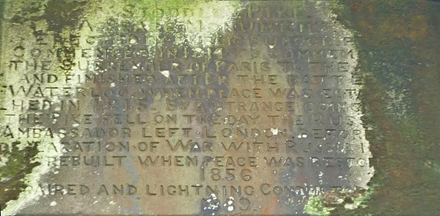
File:STOODLEY PIKE- A PEACE MONUMENT- ERECTED BY PUBLIC SUBSCRIPTION.- COMMENCED IN 1814 TO COMMEMORATE THE SURRENDER OF- PARIS TO THE ALLIES AND FINISHED AFTER THE BATTLE OF- WATERLOO WHEN PEACE WAS ESTABLISHED IN 1815. B - panoramio.jpg
Jump to navigation
Jump to search

Size of this preview: 800 × 393 pixels. Other resolutions: 320 × 157 pixels | 640 × 315 pixels | 1,253 × 616 pixels.
Original file (1,253 × 616 pixels, file size: 391 KB, MIME type: image/jpeg)
Captions
Captions
Add a one-line explanation of what this file represents
| Description | STOODLEY PIKE/ A PEACE MONUMENT/ ERECTED BY PUBLIC SUBSCRIPTION./ COMMENCED IN 1814 TO COMMEMORATE THE SURRENDER OF/ PARIS TO THE ALLIES AND FINISHED AFTER THE BATTLE OF/ WATERLOO WHEN PEACE WAS ESTABLISHED IN 1815. BY A/ STRANGE COINCIDENCE THE PIKE FELL | ||
| Date | Taken on 2 October 2010 | ||
| Source | https://web.archive.org/web/20161112054542/http://www.panoramio.com/photo/41581412 | ||
| Author | Robert Freeman | ||
| Permission (Reusing this file) |
This file is licensed under the Creative Commons Attribution-Share Alike 3.0 Unported license. Attribution: Robert Freeman
|
||
| Tags (from Panoramio photo page) | Todmorden, "Stoodley Pike" |
| Camera location | | View this and other nearby images on: OpenStreetMap |
|---|

File history
Click on a date/time to view the file as it appeared at that time.
| Date/Time | Thumbnail | Dimensions | User | Comment | |
|---|---|---|---|---|---|
| current | 06:31, 2 December 2020 | | 1,253 × 616 (391 KB) | Kreuzschnabel (talk | contribs) | cropped |
| 05:08, 12 November 2016 |  | 1,200 × 1,600 (198 KB) | Panoramio upload bot (talk | contribs) | {{Information |description=STOODLEY PIKE/ A PEACE MONUMENT/ ERECTED BY PUBLIC SUBSCRIPTION./ COMMENCED IN 1814 TO COMMEMORATE THE SURRENDER OF/ PARIS TO THE ALLIES AND FINISHED AFTER THE BATTLE OF/ WATERLOO WHEN PEACE WAS ESTABLISHED IN 1815. BY A/ STR... |
You cannot overwrite this file.
File usage on Commons
There are no pages that use this file.
File usage on other wikis
The following other wikis use this file:
- Usage on de.wikipedia.org