File:SWE-Map NUTS1-NUTS2.svg
跳转到导航
跳转到搜索

此SVG文件的PNG预览的大小:263 × 599像素。 其他分辨率:105 × 240像素 | 211 × 480像素 | 337 × 768像素 | 450 × 1,024像素 | 900 × 2,048像素 | 290 × 660像素。
原始文件 (SVG文件,尺寸为290 × 660像素,文件大小:76 KB)
说明
说明
添加一行文字以描述该文件所表现的内容
| 描述 |
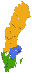
English: A map of the NUTS 1 (Lands) and NUTS 2 (National areas) subdivisions of Sweden since 2008. The colour shows which Land a particular National area belongs to.
Svenska: Sveriges Landsdelar (NUTS 1) och Riksområde (NUTS 2) sedan 2008. Färgerna anger vilken Landsdel ett riksområde tillhör.
East Sweden
South Sweden
North Sweden |
| 日期 | |
| 来源 |
Made by Lokal_Profil
|
| 作者 | Lokal_Profil |
| 授权 (二次使用本文件) |
本文件采用知识共享署名-相同方式共享 2.5 通用许可协议授权。 署名: Lokal_Profil
|
文件历史
点击某个日期/时间查看对应时刻的文件。
| 日期/时间 | 缩略图 | 大小 | 用户 | 备注 | |
|---|---|---|---|---|---|
| 当前 | 2010年5月20日 (四) 19:52 | | 290 × 660(76 KB) | Lokal Profil(留言 | 贡献) | {{Information |Description={{en|A map of the NUTS 1 (Lands) and NUTS 2 (National areas) subdivisions of Sweden since 2008. The colour shows which Land a particular National area belongs to.}} {{sv|Sveriges Landsdelar (NUTS 1) och Riksområde (NUTS 2) seda |
您不可以覆盖此文件。
文件用途
全域文件用途
以下其他wiki使用此文件:
- bs.wikipedia.org上的用途
- en.wikipedia.org上的用途
- fi.wikipedia.org上的用途
- pt.wikipedia.org上的用途
- sl.wikipedia.org上的用途
- sv.wikipedia.org上的用途
- tr.wikipedia.org上的用途
- uk.wikipedia.org上的用途
- zh.wikipedia.org上的用途