File:Sacrow-Paretzer Kanal + Potsdamer Havelbogen.png

Original file (1,401 × 1,400 pixels, file size: 906 KB, MIME type: image/png)
Captions
Captions
Summary[edit]
| Description |
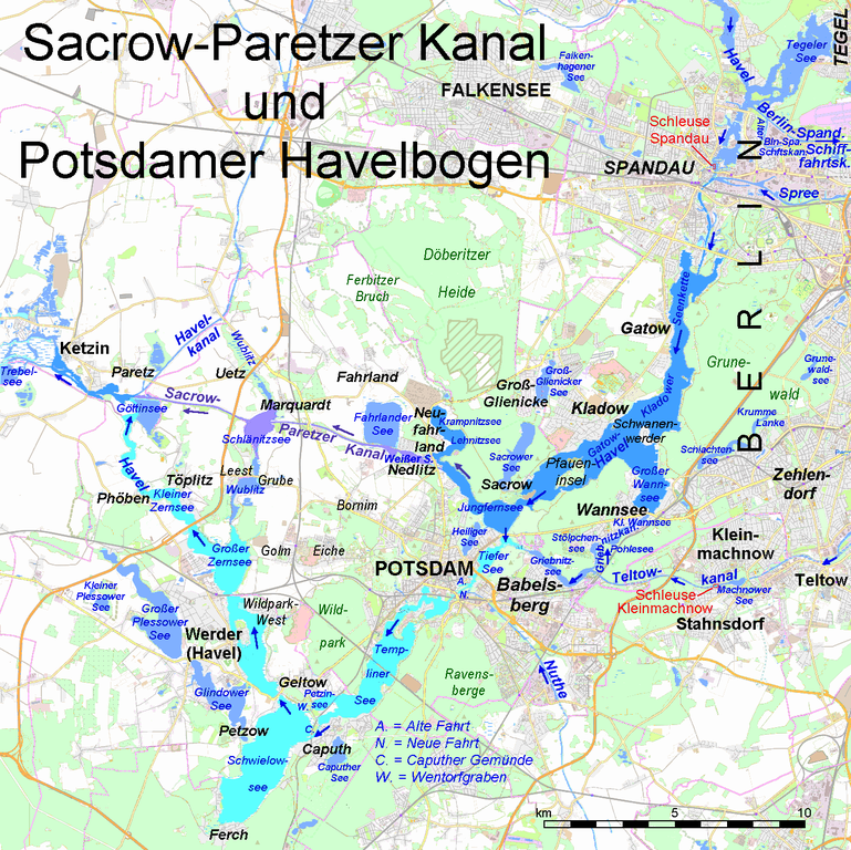
Deutsch: Karte des Sacrow-Paretzer Kanals (lila) und des parallelen Potsdamer Havelbogens (hellblau). Dunkelblau hervorgehoben die Havelabschnitte oberhalb und unterhalb, deren Flussmengen der gesamten Havel eine Referenz für die Flussmengen in Kanal und Havelbogen bilden English: Map of Sacrow-Paretzer Kanal (lilac) and the parallel natural course of River Havel (Potsdamer Havelbogen, light blue). Also emphasized (dark blue) are sections od Havel River above and below these waterbodies, where the entire flow of the river is monitored, being a reference for the flows in the canal and the Havelbogen. |
|||||||||||||||
| Date | ||||||||||||||||
| Source |
|
|||||||||||||||
| Author | Ulamm (talk) | |||||||||||||||
| Other versions |
Sources of research[edit]
- Für den Berlin-Spandauer Schifffahrtskanal:
- FIS-Broker JSC Kartenanzeige FIS-Broker JSC-Vorschau-Digitale Topographische Karte 1: 25 000 (DTK25)]: „Berlin-Spandauer Schifffahrtskanal (Hohenzollernkanal)“
- Für den Griebnitzkanal:
- http://www.werder-havel.de/pdf/tourismus/WWK_potsd_brb_havelseen_WEB.pdf
- Bundesgesetzblatt von 1995 mit Geschwindigkeitsverordnung zu Havelseen
- http://www.schiffahrt-in-potsdam.de/pages/fahrplan_2016.htm
Note[edit]
The names of bodies of water shown in http://www.berlin.de/stadtplan/ are not official and differ from the official names.
Licensing[edit]

|
Permission is granted to copy, distribute and/or modify this document under the terms of the GNU Free Documentation License, Version 1.2 or any later version published by the Free Software Foundation; with no Invariant Sections, no Front-Cover Texts, and no Back-Cover Texts. A copy of the license is included in the section entitled GNU Free Documentation License. |
- You are free:
- to share – to copy, distribute and transmit the work
- to remix – to adapt the work
- Under the following conditions:
- attribution – You must give appropriate credit, provide a link to the license, and indicate if changes were made. You may do so in any reasonable manner, but not in any way that suggests the licensor endorses you or your use.
- share alike – If you remix, transform, or build upon the material, you must distribute your contributions under the same or compatible license as the original.
File history
Click on a date/time to view the file as it appeared at that time.
| Date/Time | Thumbnail | Dimensions | User | Comment | |
|---|---|---|---|---|---|
| current | 18:34, 1 May 2016 | | 1,401 × 1,400 (906 KB) | Ulamm (talk | contribs) | background without labels |
| 13:21, 1 May 2016 |  | 1,400 × 1,400 (1.68 MB) | Ulamm (talk | contribs) | colours of the locks; names of two landscapes | |
| 12:48, 1 May 2016 |  | 1,400 × 1,400 (1.73 MB) | Ulamm (talk | contribs) | {{Information |Description={{de|1=Karte des Sacrow-Paretzer Kanals (lila) und des parallelen Potsdamer Havelbogens (hellblau). Dunkelblau hervorgehoben die Havelabschnitte oberhalb und unterhalb, deren Flussmengen der gesamten Havel eine Referenz für... |
You cannot overwrite this file.
File usage on Commons
The following 5 pages use this file:
File usage on other wikis
The following other wikis use this file:
- Usage on de.wikipedia.org
- Usage on pl.wikipedia.org