File:Salan05 map.png
Jump to navigation
Jump to search
Size of this preview: 800 × 560 pixels. Other resolutions: 320 × 224 pixels | 640 × 448 pixels | 1,018 × 713 pixels.
Original file (1,018 × 713 pixels, file size: 52 KB, MIME type: image/png)
Captions
Captions
Add a one-line explanation of what this file represents
Summary
[edit]
| Description |
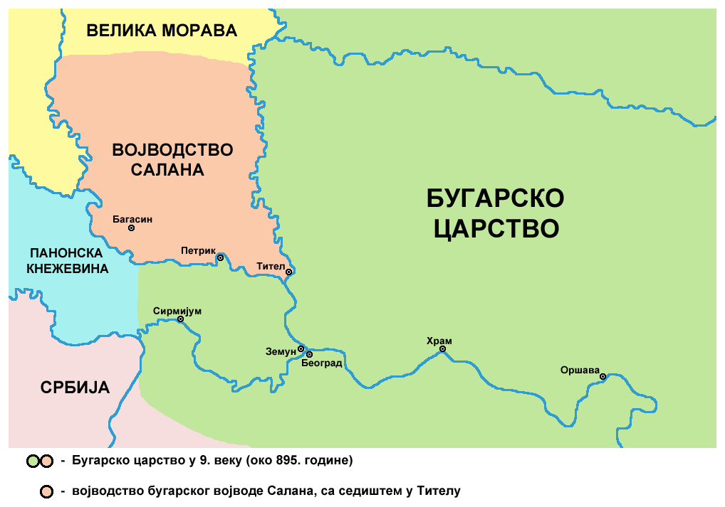
English: historical map of medieval duchy of Bulgarian duke Salan (9th century) - Serbian language version
Српски / srpski: историјска карта средњовековног војводства бугарског војводе Салана (9. век) - верзија на српском језику |
| Date | 9 February 2009 (original upload date) |
| Source | Own work |
| Author | PANONIAN |
References
[edit]
Published references:
- Dr Aleksa Ivić, Istorija Srba u Vojvodini, Novi Sad, 1929.
- Radmilo Petrović, Vojvodina - petnaest milenijuma kulturne istorije, Beograd, 2003.
- Jovan Pejin, Velikomađarski kapric, Zrenjanin, 2007.
- Marko Jovanov, Devet vekova od pomena imena Titela, Titelski letopis, Titel, 2001.
- Istorijski atlas, Zavod za udžbenike i nastavna sredstva - Zavod za kartografiju "Geokarta", Beograd, 1999.
- Petrit Imami, Srbi i Albanci kroz vekove, Beograd, 2000.
Internet references:
Licensing
[edit]
| I, the copyright holder of this work, release this work into the public domain. This applies worldwide. In some countries this may not be legally possible; if so: I grant anyone the right to use this work for any purpose, without any conditions, unless such conditions are required by law. |
File history
Click on a date/time to view the file as it appeared at that time.
| Date/Time | Thumbnail | Dimensions | User | Comment | |
|---|---|---|---|---|---|
| current | 20:12, 13 May 2014 | | 1,018 × 713 (52 KB) | PANONIAN (talk | contribs) | aesthetics |
| 11:10, 5 March 2011 |  | 1,020 × 713 (52 KB) | PANONIAN (talk | contribs) | aesthetical correction | |
| 07:24, 15 September 2009 |  | 1,020 × 713 (52 KB) | PANONIAN (talk | contribs) | Reverted to version as of 15:50, 29 July 2009 - fixing thumbnail problem | |
| 07:23, 15 September 2009 |  | 1,020 × 713 (52 KB) | PANONIAN (talk | contribs) | Reverted to version as of 15:50, 29 July 2009 - fixing thumbnail problem | |
| 07:23, 15 September 2009 |  | 542 × 474 (45 KB) | PANONIAN (talk | contribs) | Reverted to version as of 21:09, 20 June 2009 - fixing thumbnail problem | |
| 15:50, 29 July 2009 |  | 1,020 × 713 (52 KB) | PANONIAN (talk | contribs) | ||
| 21:09, 20 June 2009 |  | 542 × 474 (45 KB) | PANONIAN (talk | contribs) | since this is a duplicate of another file (File:Salan.png), I translated this one into Serbian language | |
| 23:07, 17 March 2009 |  | 542 × 474 (39 KB) | PANONIAN (talk | contribs) | ||
| 23:45, 9 February 2009 |  | 626 × 610 (50 KB) | PANONIAN (talk | contribs) | historical map of medieval duchy of duke Salan (self made) {{PD-self}} Category:Maps of the history of Vojvodina Category:Maps of the history of Serbia |
You cannot overwrite this file.
File usage on Commons
There are no pages that use this file.
File usage on other wikis
The following other wikis use this file:
- Usage on mk.wikipedia.org
- Usage on sr.wikipedia.org