File:Sanjak of Novibazar.png
Zur Navigation springen
Zur Suche springen

Größe dieser Vorschau: 531 × 600 Pixel. Weitere Auflösungen: 212 × 240 Pixel | 425 × 480 Pixel | 786 × 888 Pixel.
Originaldatei (786 × 888 Pixel, Dateigröße: 75 KB, MIME-Typ: image/png)
Bildtexte
Kurzbeschreibungen
Ergänze eine einzeilige Erklärung, was diese Datei darstellt.
Beschreibung
[Bearbeiten]
| Beschreibung |
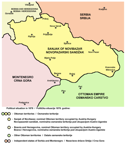
English: Map of the Sanjak of Novibazar, nominal territory of the Ottoman Empire under Austro-Hungarian occupation in 1878.
Српски / srpski: Mapa Novopazarskog sandžaka, nominalne teritorije Osmanskog carstva pod Austro-Ugarskom okupacijom 1878. godine. |
| Datum | 23. Mai 2006 (Original-Hochladedatum) |
| Quelle | Eigenes Werk |
| Urheber | PANONIAN |
Source
[Bearbeiten]
Made by PANONIAN, Uploaded in Commons by Lohe.
Lizenz
[Bearbeiten]
self-made map by user:PANONIAN
| Ich, der Urheberrechtsinhaber dieses Werkes, veröffentliche es als gemeinfrei. Dies gilt weltweit. In manchen Staaten könnte dies rechtlich nicht möglich sein. Sofern dies der Fall ist: Ich gewähre jedem das bedingungslose Recht, dieses Werk für jedweden Zweck zu nutzen, es sei denn, Bedingungen sind gesetzlich erforderlich. |
References
[Bearbeiten]
- http://terkepek.adatbank.transindex.ro/kepek/netre/258.gif
- http://www.historyonmaps.com/ColourSamples/cbig/DissolutionMilitayFrontier.jpg
- http://www.lib.utexas.edu/maps/historical/eastern_europe1878.jpg
- http://images.nationmaster.com/images/motw/historical/balkans_1912.jpg
- http://maps.grida.no/library/files/storage/balkans-history-_003.png
- The Times History of Europe, Times Books, London, 2002.
- Istorijski atlas, Geokarta, Beograd, 1999.
- Školski istorijski atlas, Zavod za izdavanje udžbenika SR Srbije, Beograd, 1970.
- Povijesni atlas, Učila - Zagreb, Zagreb, 1971.
- Denis Šehić - Demir Šehić, Istorijski atlas sveta, Beograd, 2007.
Dateiversionen
Klicke auf einen Zeitpunkt, um diese Version zu laden.
| Version vom | Vorschaubild | Maße | Benutzer | Kommentar | |
|---|---|---|---|---|---|
| aktuell | 10:57, 25. Okt. 2010 | | 786 × 888 (75 KB) | PANONIAN (Diskussion | Beiträge) | improved version |
| 19:08, 23. Mai 2006 |  | 758 × 534 (8 KB) | Lohe (Diskussion | Beiträge) | Map of the Sanjak of Novibazar, historical territory belonging to the Ottoman Balkans in the 19th century. Made by en:User:PANONIAN Uploaded in Commons by it:Utente:Lohe |
Du kannst diese Datei nicht überschreiben.
Dateiverwendung
Die folgenden 3 Seiten verwenden diese Datei:
Globale Dateiverwendung
Die nachfolgenden anderen Wikis verwenden diese Datei:
- Verwendung auf am.wikipedia.org
- Verwendung auf arz.wikipedia.org
- Verwendung auf bg.wikipedia.org
- Verwendung auf ca.wikipedia.org
- Verwendung auf de.wikipedia.org
- Verwendung auf el.wikipedia.org
- Verwendung auf en.wikipedia.org
- Verwendung auf fr.wikipedia.org
- Verwendung auf gl.wikipedia.org
- Verwendung auf hr.wikipedia.org
- Verwendung auf it.wikipedia.org
- Verwendung auf mk.wikipedia.org
- Verwendung auf no.wikipedia.org
- Verwendung auf sh.wikipedia.org
- Verwendung auf sq.wikipedia.org
Kategorien:
- Sanjak of Novi Pazar
- Maps of the history of Sandžak
- Maps of the Ottoman period in the history of Serbia
- Maps of the history of Montenegro under Ottoman and Venetian rule
- Maps of the history of Kosovo under Ottoman Empire
- Maps of sanjaks of the Ottoman Empire
- Maps of the Ottoman Empire in the 19th century
- Political maps of Austria-Hungary
- Serbian-language maps