File:Sanjak of Novibazar.png
Aller à la navigation
Aller à la recherche

Taille de cet aperçu : 531 × 600 pixels. Autres résolutions : 212 × 240 pixels | 425 × 480 pixels | 786 × 888 pixels.
Fichier d’origine (786 × 888 pixels, taille du fichier : 75 kio, type MIME : image/png)
Légendes
Légendes
Ajoutez en une ligne la description de ce que représente ce fichier
Description[modifier]
| Description |
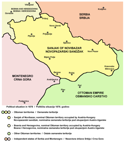
English: Map of the Sanjak of Novibazar, nominal territory of the Ottoman Empire under Austro-Hungarian occupation in 1878.
Српски / srpski: Mapa Novopazarskog sandžaka, nominalne teritorije Osmanskog carstva pod Austro-Ugarskom okupacijom 1878. godine. |
| Date | 23 mai 2006 (date de téléversement originale) |
| Source | Travail personnel |
| Auteur | PANONIAN |
Source[modifier]
Made by PANONIAN, Uploaded in Commons by Lohe.
Conditions d’utilisation[modifier]
self-made map by user:PANONIAN
| Moi, propriétaire des droits d’auteur sur cette œuvre, la place dans le domaine public. Ceci s'applique dans le monde entier. Dans certains pays, ceci peut ne pas être possible ; dans ce cas : J’accorde à toute personne le droit d’utiliser cette œuvre dans n’importe quel but, sans aucune condition, sauf celles requises par la loi. |
References[modifier]
- http://terkepek.adatbank.transindex.ro/kepek/netre/258.gif
- http://www.historyonmaps.com/ColourSamples/cbig/DissolutionMilitayFrontier.jpg
- http://www.lib.utexas.edu/maps/historical/eastern_europe1878.jpg
- http://images.nationmaster.com/images/motw/historical/balkans_1912.jpg
- http://maps.grida.no/library/files/storage/balkans-history-_003.png
- The Times History of Europe, Times Books, London, 2002.
- Istorijski atlas, Geokarta, Beograd, 1999.
- Školski istorijski atlas, Zavod za izdavanje udžbenika SR Srbije, Beograd, 1970.
- Povijesni atlas, Učila - Zagreb, Zagreb, 1971.
- Denis Šehić - Demir Šehić, Istorijski atlas sveta, Beograd, 2007.
Historique du fichier
Cliquer sur une date et heure pour voir le fichier tel qu'il était à ce moment-là.
| Date et heure | Vignette | Dimensions | Utilisateur | Commentaire | |
|---|---|---|---|---|---|
| actuel | 25 octobre 2010 à 10:57 | | 786 × 888 (75 kio) | PANONIAN (d | contributions) | improved version |
| 23 mai 2006 à 19:08 |  | 758 × 534 (8 kio) | Lohe (d | contributions) | Map of the Sanjak of Novibazar, historical territory belonging to the Ottoman Balkans in the 19th century. Made by en:User:PANONIAN Uploaded in Commons by it:Utente:Lohe |
Vous ne pouvez pas remplacer ce fichier.
Utilisations locales du fichier
Les 3 pages suivantes utilisent ce fichier :
Utilisations du fichier sur d’autres wikis
Les autres wikis suivants utilisent ce fichier :
- Utilisation sur am.wikipedia.org
- Utilisation sur arz.wikipedia.org
- Utilisation sur bg.wikipedia.org
- Utilisation sur ca.wikipedia.org
- Utilisation sur de.wikipedia.org
- Utilisation sur el.wikipedia.org
- Utilisation sur en.wikipedia.org
- Utilisation sur fr.wikipedia.org
- Utilisation sur gl.wikipedia.org
- Utilisation sur hr.wikipedia.org
- Utilisation sur it.wikipedia.org
- Utilisation sur mk.wikipedia.org
- Utilisation sur no.wikipedia.org
- Utilisation sur sh.wikipedia.org
- Utilisation sur sq.wikipedia.org
Catégories :
- Sanjak of Novi Pazar
- Maps of the history of Sandžak
- Maps of the Ottoman period in the history of Serbia
- Maps of the history of Montenegro under Ottoman and Venetian rule
- Maps of the history of Kosovo under Ottoman Empire
- Maps of sanjaks of the Ottoman Empire
- Maps of the Ottoman Empire in the 19th century
- Political maps of Austria-Hungary
- Serbian-language maps