File:Satellite Temperatures.png
از Wikimedia Commons
پرش به ناوبری
پرش به جستجو
اندازهٔ این پیشنمایش: ۸۰۰ × ۵۳۰ پیکسل. کیفیتهای دیگر: ۳۲۰ × ۲۱۲ پیکسل | ۶۴۰ × ۴۲۴ پیکسل | ۱٬۰۲۴ × ۶۷۸ پیکسل | ۱٬۲۸۰ × ۸۴۸ پیکسل | ۲٬۴۰۰ × ۱٬۵۹۰ پیکسل.
پروندهٔ اصلی (۲٬۴۰۰ × ۱٬۵۹۰ پیکسل، اندازهٔ پرونده: ۲۹۷ کیلوبایت، نوع MIME پرونده: image/png)
اطلاعات پرونده
دادههای ساختاریافته
گزینهها
توضیحSatellite Temperatures.png |
(UAH 2003; data set tltglhmam version 5.2 with 2009 updates) and Schabel et al. (RSS 2002; data set tlt_land_and_ocean with 2009 updates). These two satellite records reflect two different ways of interpreting the same set of microwave sounder measurements and are not independent records. Each record is plotted as the monthly average and straight lines are fit through each data set from January 1982 to December 2009. The slope of these lines are 0.187°C/decade, 0.163°C/decade, and 0.239°C/decade for the surface, UAH, and RSS respectively. The 5.2 version of Christy et al.'s satellite temperature record contains a significant correction over previous versions. In summer 2005, Mears and Wentz (2005) discovered that the UAH processing algorithms were incorrectly adjusting for diurnal variations, especially at low latitude. This correction raised the trend line 0.035°C/decade, and in so doing brought it into much better agreement with the ground based records and with independent satellite based analysis (e.g. Fu et al. 2004). The discovery of this error also explains why their satellite based temperature trends had disagreed most prominently in the tropics. Within measurement error, all of these records paint a similar picture of temperature change and global warming. However, climate models predict carbon dioxide based greenhouse warming should result in lower atmosphere warming roughly 1.3 times higher than the surface warming. This prediction is consistent with the RSS vs. surface comparison, though by contrast the UAH vs. surface comparison suggests a troposphere warming by slightly less than the surface of the Earth. Note: In the above figure, there is still a significant discrepancy between the very earliest satellite measurements and the ground based measurements at that time. For this reason only the interval 1982-2005 was used in calculating each trend. Including the earliest years leads to a wider dispersion , with trends of 0.170°C/decade, 0.116°C/decade, and 0.192°C/decade for the surface, UAH, and RSS data respectively. The origin of this discrepancy is unclear. This figure was prepared by Robert A. Rohde from publicly available data and is incorporated into the Global Warming Art project.
|
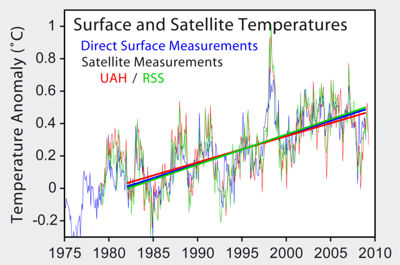
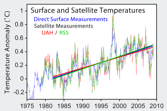
منبع | http://www.cru.uea.ac.uk/cru/data/temperature/ |
پدیدآور | Robert A. Rohde |
خلاصه ==
اطلاعات بیشتر: Satellite temperature measurements
Image from Global Warming Art
This image is an original work created for Global Warming Art. Please refer to the image description page for more information.
اجازهٔ کپی، پخش و/یا تغییر این سند تحت شرایط مجوز مستندات آزاد گنو، نسخهٔ ۱٫۲ یا هر نسخهٔ بعدتری که توسط بنیاد نرمافزار آزاد منتشر شده؛ بدون بخشهای ناوردا (نامتغیر)، متون روی جلد، و متون پشت جلد، اعطا میشود. یک کپی از مجوز در بخشی تحت عنوان مجوز مستندات آزاد گنو ضمیمه شده است.http://www.gnu.org/copyleft/fdl.htmlGFDLGNU Free Documentation Licensetruetrue |
این پرونده با اجازهنامهٔ کریتیو کامانز Attribution-Share Alike 3.0 سازگار نشده منتشر شده است. | ||
| ||
این برچسب مجوز بهعنوان بخشی از روزآمدسازی مجوز GFDL، به این پرونده افزوده شد.http://creativecommons.org/licenses/by-sa/3.0/CC BY-SA 3.0Creative Commons Attribution-Share Alike 3.0truetrue |
تاریخچهٔ پرونده
روی تاریخ/زمانها کلیک کنید تا نسخهٔ مربوط به آن هنگام را ببینید.
تاریخ/زمان | بندانگشتی | ابعاد | کاربر | توضیح | |
---|---|---|---|---|---|
کنونی | ۳۱ ژوئیهٔ ۲۰۰۹، ساعت ۲۰:۳۰ | ۲٬۴۰۰ در ۱٬۵۹۰ (۲۹۷ کیلوبایت) | Dragons flight (بحث | مشارکتها) | update | |
۱۰ آوریل ۲۰۰۶، ساعت ۰۷:۱۰ | ۵۱۲ در ۳۶۳ (۳۰ کیلوبایت) | Pflatau (بحث | مشارکتها) |
شما نمیتوانید این پرونده را رونویسی کنید.
کاربرد پرونده
صفحهٔ زیر از این تصویر استفاده میکند:
کاربرد سراسری پرونده
ویکیهای دیگر زیر از این پرونده استفاده میکنند:
- کاربرد در ca.wikipedia.org
- کاربرد در de.wikipedia.org
- کاربرد در en.wikipedia.org
- Satellite temperature measurement
- Leipzig Declaration
- User:Dragons flight/Images
- Temperature measurement
- User:C-randles
- Friends of Science
- Talk:Friends of Science
- User:Debnigo
- File talk:Satellite Temperatures.png
- User:Merlinme/Sandbox
- Microwave Sounding Unit temperature measurements
- Wikipedia:Reference desk/Archives/Science/2011 June 13
- User talk:Sailsbystars/Archive 2
- کاربرد در es.wikipedia.org
- کاربرد در fa.wikipedia.org
- کاربرد در fr.wikipedia.org
- کاربرد در ko.wikipedia.org
- کاربرد در pl.wikipedia.org
- کاربرد در pt.wikipedia.org