File:Satellite image of Singapore (Landsat 7) - 20000428.jpg
跳转到导航
跳转到搜索

本预览的尺寸:800 × 467像素。 其他分辨率:320 × 187像素 | 640 × 373像素 | 1,024 × 597像素 | 1,280 × 747像素 | 2,560 × 1,493像素 | 4,800 × 2,800像素。
原始文件 (4,800 × 2,800像素,文件大小:3.77 MB,MIME类型:image/jpeg)
说明
说明
添加一行文字以描述该文件所表现的内容
摘要
[编辑]_-_20000428.jpg&action=edit§ion=1)
| 描述 |
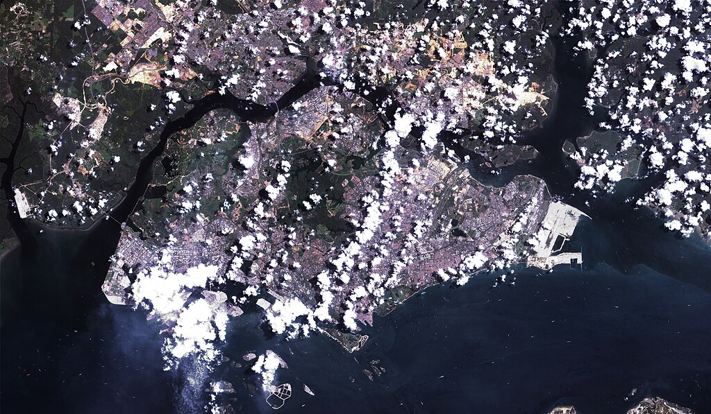
English: A Landsat 7 image of Singapore at 14.25-meter resolution. Based on Global Orthorectified Landsat dataset (ETM+); WRS_PATH 125, WRS_ROW 59. Generated using panchromatic band for intensity, and color from "true-color" combination of 28.5-meter resolution bands 3, 2, and 1 (as R, G, B respectively). Data combined and color curves enhanced in the Gimp. |
| 日期 | Data acquisition: 2000年4月28日. Orthorectified version produced: 2002年12月4日. This image created: 2007年2月6日. |
| 来源 | Data from the USGS GloVis server. Landsat Orthorectified data generated through NASA's Commercial Remote Sensing Program. |
| 作者 | Data: National Aeronautics and Space Administration (NASA). Image: Dave Pape. |
| 授权 (二次使用本文件) |
Original data PD-NASA; any copyright that exists from my creation of this image is dedicated to the public domain (PD-SELF). |
| 相机位置 | | 在以下服务上查看本图像和附近其他图像: OpenStreetMap |
|---|
_-_20000428.jpg¶ms=001.299708_N_0103.850327_E_globe:Earth_type:camera_type:landmark_&language=zh-my)
许可协议
[编辑]_-_20000428.jpg&action=edit§ion=2)
| 本文件完全由NASA创作,在美国属于公有领域。根据NASA的版权方针,NASA的材料除非另有声明否则不受版权保护。(参见Template:PD-USGov/zh、NASA版权方针页面或JPL图片使用方针。) | ||
 |
警告:
|
文件历史
点击某个日期/时间查看对应时刻的文件。
| 日期/时间 | 缩略图 | 大小 | 用户 | 备注 | |
|---|---|---|---|---|---|
| 当前 | 2007年2月6日 (二) 18:29 | | 4,800 × 2,800(3.77 MB) | Davepape(留言 | 贡献) | {{af|style="margin-left:0.5em;" width="300px"> }} {{am|'''ሲንጋፖር''' am:ከተማ-አገር ነው።}} {{an|A '''Republica de Singapur''' (En anglés ''Republic of Singapore''; en chin 新加坡共 |
您不可以覆盖此文件。
文件用途
以下2个页面使用本文件:
全域文件用途
以下其他wiki使用此文件:
- it.wikibooks.org上的用途
- trv.wikipedia.org上的用途
- zh.wikipedia.org上的用途
_-_20000428.jpg&oldid=571072910)