File:Saupark.png
Jump to navigation
Jump to search

Size of this preview: 788 × 599 pixels. Other resolutions: 316 × 240 pixels | 631 × 480 pixels | 953 × 725 pixels.
Original file (953 × 725 pixels, file size: 473 KB, MIME type: image/png)
Captions
Captions
Add a one-line explanation of what this file represents
Summary
[edit]
| Description |
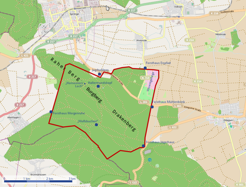
English: Position of Saupark Springe and track of the Saupark wall
Deutsch: Verlauf der Mauer des Sauparks Springe |
||||||||||||
| Date | |||||||||||||
| Source | Own work | ||||||||||||
| Author | Kreuzschnabel | ||||||||||||
| Permission (Reusing this file) |
|
File history
Click on a date/time to view the file as it appeared at that time.
| Date/Time | Thumbnail | Dimensions | User | Comment | |
|---|---|---|---|---|---|
| current | 01:41, 27 February 2012 | | 953 × 725 (473 KB) | Kreuzschnabel (talk | contribs) | +POI, +Berge |
| 13:09, 7 February 2012 |  | 953 × 725 (461 KB) | Kreuzschnabel (talk | contribs) | Kartengrundlage neu / base map renewed | |
| 12:56, 7 February 2012 |  | 953 × 725 (458 KB) | Kreuzschnabel (talk | contribs) | faulty blue areas removed | |
| 12:51, 7 February 2012 |  | 953 × 725 (455 KB) | Kreuzschnabel (talk | contribs) | Ergänzung/Supplement: „Wolfsbuchen“ | |
| 12:24, 7 February 2012 |  | 953 × 725 (459 KB) | Kreuzschnabel (talk | contribs) | Ergänzungen/Supplements: Maßstab/Scale, Wisentgehege, Hallermundskopf | |
| 08:16, 7 February 2012 |  | 953 × 725 (458 KB) | Kreuzschnabel (talk | contribs) | {{Information |Description ={{en|1=Position of Saupark Springe and track of the Saupark wall}} {{de|1=Verlauf der Mauer des Sauparks Springe}} |Source ={{own}} |Author =Kreuzschnabel |Date =2012-02-06 |P |
You cannot overwrite this file.
File usage on Commons
There are no pages that use this file.