File:Saxton Somerset uncoloured 1579.jpg
Jump to navigation
Jump to search

Size of this preview: 769 × 600 pixels. Other resolutions: 308 × 240 pixels | 616 × 480 pixels | 985 × 768 pixels | 1,280 × 998 pixels | 2,560 × 1,996 pixels | 3,000 × 2,339 pixels.
Original file (3,000 × 2,339 pixels, file size: 1.34 MB, MIME type: image/jpeg)
Captions
Captions
Add a one-line explanation of what this file represents
Summary[edit]
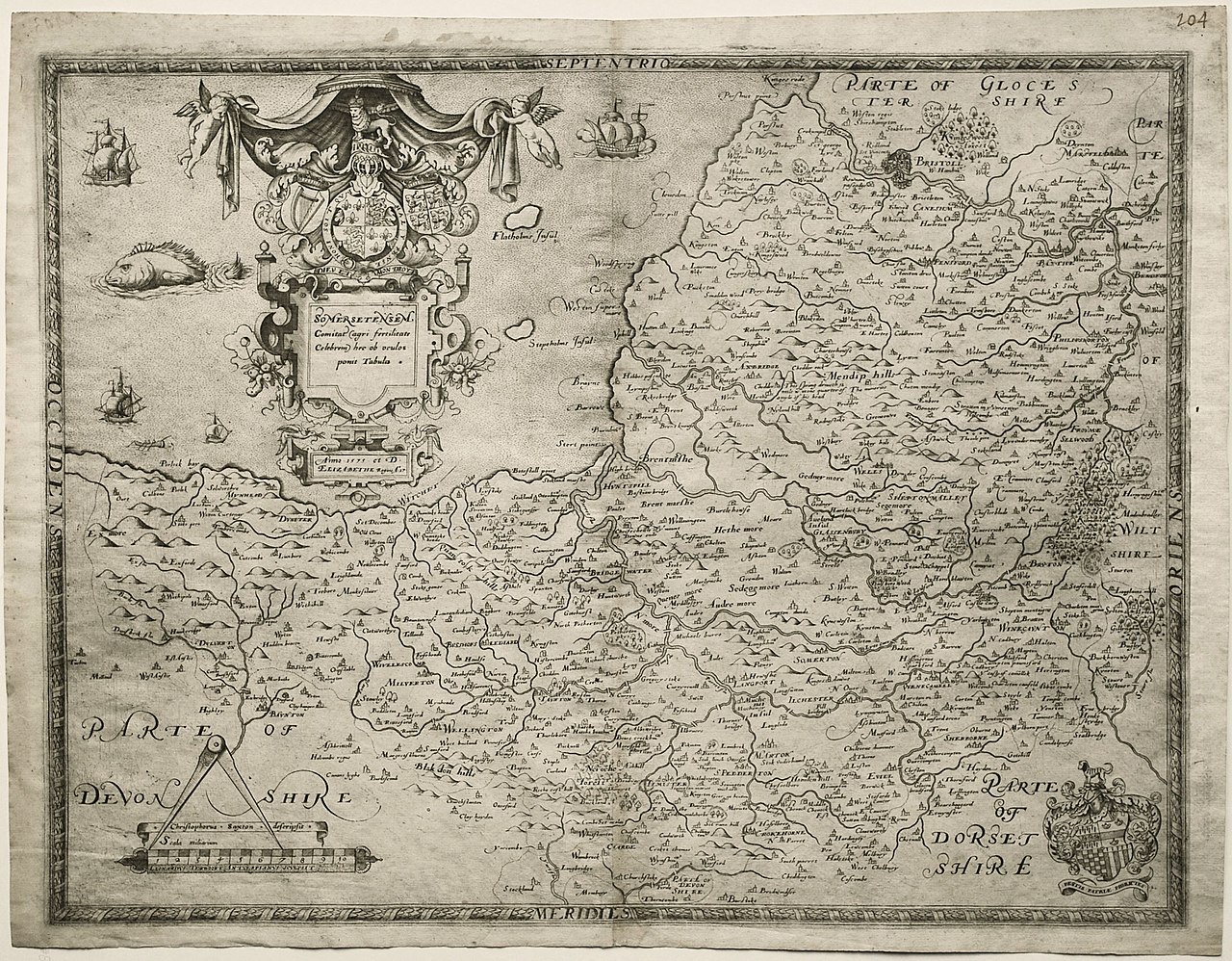
| Title |
Latina: Somersetensem Comitat[us] |
|||||||||||||||||||||||||||||
| Description |
English: Uncoloured print of Christopher Saxton's map of Somerset, 1579 |
|||||||||||||||||||||||||||||
| Date | circa 1579 | |||||||||||||||||||||||||||||
| Source | Maps Perhaps Image | |||||||||||||||||||||||||||||
| Creator |
|
|||||||||||||||||||||||||||||
| Geotemporal data | ||||||||||||||||||||||||||||||
| Date depicted | ||||||||||||||||||||||||||||||
| Map location | Somerset | |||||||||||||||||||||||||||||
| Map type | county map | |||||||||||||||||||||||||||||
| Georeferencing | If inappropriate please set warp_status = skip to hide. | |||||||||||||||||||||||||||||
| Bibliographic data | ||||||||||||||||||||||||||||||
| Language | Latin | |||||||||||||||||||||||||||||
| Place of publication | London | |||||||||||||||||||||||||||||
| Publisher |
Christopher Saxton |
|||||||||||||||||||||||||||||
| Archival data | ||||||||||||||||||||||||||||||
| Medium | engraving | |||||||||||||||||||||||||||||
| Inscriptions |
Title top left: Somersetensem Comitat[us] (agri fertilitate Celebrem) hec ob oculos ponit Tabula
Date top left: Anno · 1575 · et D: / Elizabethe Regine A:o 17
bottom left: Leonardus Terwoort Antverpianus sculpsit
bottom left: Christophorus Saxton descripsit
|
|||||||||||||||||||||||||||||
| artwork-references | Skelton, R. A. (1978-) County atlases of the British Isles, 1579-1850 : a bibliography, Folkestone, Eng.: Dawson, pp. 12−16 ISBN: 0-7129-0873-0. OCLC: 5094281. | |||||||||||||||||||||||||||||
Licensing[edit]
|
This is a faithful photographic reproduction of a two-dimensional, public domain work of art. The work of art itself is in the public domain for the following reason:
The official position taken by the Wikimedia Foundation is that "faithful reproductions of two-dimensional public domain works of art are public domain".
This photographic reproduction is therefore also considered to be in the public domain in the United States. In other jurisdictions, re-use of this content may be restricted; see Reuse of PD-Art photographs for details. | ||||
File history
Click on a date/time to view the file as it appeared at that time.
| Date/Time | Thumbnail | Dimensions | User | Comment | |
|---|---|---|---|---|---|
| current | 19:40, 30 March 2021 | | 3,000 × 2,339 (1.34 MB) | PKM (talk | contribs) | {{Map |title ={{la|Somersetensem Comitat[us]}} |description ={{en|Uncoloured print of Christopher Saxton's map of Somerset, 1579}} |legend = |author ={{creator:Christopher Saxton}}{{creator:Leonard Terwoort}} |image = |date ={{otherdate|ca|1579}} |source =[https://www.mapsperhaps.com/products/somersetensem-comitat-agri-fertilitate-celebrem-hec-ob-oculo Maps Perhaps] [https://www.mapsperhaps.com/application/file... |
You cannot overwrite this file.
File usage on Commons
There are no pages that use this file.
File usage on other wikis
The following other wikis use this file:
- Usage on www.wikidata.org