File:Schärding Burggraben 14 Innlände Stadtmauer GstNr 89.JPG
Jump to navigation
Jump to search

Size of this preview: 800 × 531 pixels. Other resolutions: 320 × 213 pixels | 640 × 425 pixels | 1,024 × 680 pixels | 1,280 × 850 pixels | 2,560 × 1,700 pixels | 4,288 × 2,848 pixels.
Original file (4,288 × 2,848 pixels, file size: 2.57 MB, MIME type: image/jpeg)
Captions
Captions
Add a one-line explanation of what this file represents
Summary[edit]
| Description |
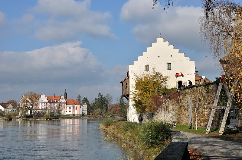
Deutsch: Wohnhaus, ehem. Getreidekasten in Schärding. Jenseits des Inns sieht man Schloss Neuhaus und die Expositurkirche zur Hl. Dreifaltigkeit. Diese Bauwerke stehen auf der Liste der Baudenkmäler in Neuhaus am Inn unter den Aktenzeichen D-2-75-134-2 und D-2-75-134-1.
English: Residential building, former granary of Schärding.This building is protected as cultural heritage monument of Austria. At the other side of the river there is castle Neuhaus (Germany) and the subsidiary church Holy Trinity. These buildings are protected as cultural heritage monuments of Bavaria (Germany).
|
||||
| Date | |||||
| Source | Own work | ||||
| Author | Isiwal |
| Object location | | View this and other nearby images on: OpenStreetMap |
|---|
Licensing[edit]
I, the copyright holder of this work, hereby publish it under the following license:
This file is licensed under the Creative Commons Attribution-Share Alike 3.0 Austria license.
- You are free:
- to share – to copy, distribute and transmit the work
- to remix – to adapt the work
- Under the following conditions:
- attribution – You must give appropriate credit, provide a link to the license, and indicate if changes were made. You may do so in any reasonable manner, but not in any way that suggests the licensor endorses you or your use.
- share alike – If you remix, transform, or build upon the material, you must distribute your contributions under the same or compatible license as the original.

| Annotations | This image is annotated: View the annotations at Commons |
This image has been assessed using the Quality image guidelines and is considered a Quality image.
|
File history
Click on a date/time to view the file as it appeared at that time.
| Date/Time | Thumbnail | Dimensions | User | Comment | |
|---|---|---|---|---|---|
| current | 18:51, 10 November 2012 | | 4,288 × 2,848 (2.57 MB) | Isiwal (talk | contribs) | User created page with UploadWizard |
You cannot overwrite this file.
File usage on Commons
The following 2 pages use this file: