File:Serb lands pl.png
Jump to navigation
Jump to search

Size of this preview: 739 × 599 pixels. Other resolutions: 296 × 240 pixels | 592 × 480 pixels | 926 × 751 pixels.
Original file (926 × 751 pixels, file size: 77 KB, MIME type: image/png)
Captions
Captions
Add a one-line explanation of what this file represents
Summary
[edit]
| Description |
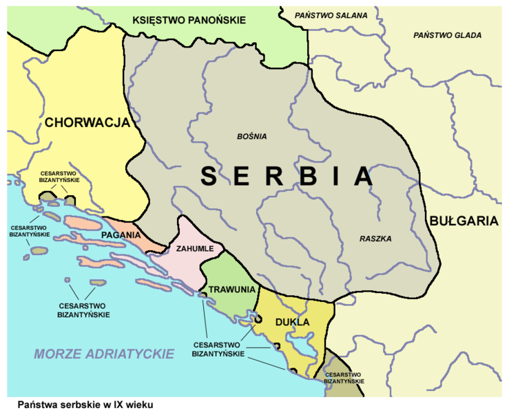
English: Serb lands in the 9th century - Polish language version.
Polski: Państwa serbskie w IX wieku. |
| Date | |
| Source | http://commons.wikimedia.org/wiki/File:Serb_lands04.png - author of that map is User:PANONIAN |
| Author | derivative work - translation into Polish: Ałiku, later version was uploaded by User:PANONIAN. |
Licensing
[edit]
I, the copyright holder of this work, hereby publish it under the following licenses:

|
Permission is granted to copy, distribute and/or modify this document under the terms of the GNU Free Documentation License, Version 1.2 or any later version published by the Free Software Foundation; with no Invariant Sections, no Front-Cover Texts, and no Back-Cover Texts. A copy of the license is included in the section entitled GNU Free Documentation License. |
This file is licensed under the Creative Commons Attribution-Share Alike Attribution-Share Alike 4.0 International, 3.0 Unported, 2.5 Generic, 2.0 Generic and 1.0 Generic license.
- You are free:
- to share – to copy, distribute and transmit the work
- to remix – to adapt the work
- Under the following conditions:
- attribution – You must give appropriate credit, provide a link to the license, and indicate if changes were made. You may do so in any reasonable manner, but not in any way that suggests the licensor endorses you or your use.
- share alike – If you remix, transform, or build upon the material, you must distribute your contributions under the same or compatible license as the original.
You may select the license of your choice.
References
[edit]
- Istorijski atlas, Geokarta, Beograd, 1999.
- Miloš Blagojević, Srpska državnost u srednjem veku, Beograd, 2011.
- Vladimir Ćorović, Ilustrovana istorija Srba, knjiga prva, Beograd, 2005.
- Petrit Imami, Srbi i Albanci kroz vekove, Beograd, 2000.
- Školski istorijski atlas, Zavod za izdavanje udžbenika SR Srbije, Beograd, 1970.
- The Times, Atlas Svjetske Povijesti, Cankarjeva založba, Ljubljana - Zagreb, 1986.
- Sima M. Ćirković, Srbi među evropskim narodima, Beograd, 2004.
- Sve srpske mape - od šestog veka do Pariza, Specijalno izdanje BLICA, Decembar 1995
- http://www.magelanpress.rs/media/k2/items/cache/ada9a09acea936d776a6f55c82778c43_XL.jpg[dead link]
- http://www.delfi.rs/_img/artikli/2014/05/istorijska_geografija_srpskih_zemalja_od_6_do_polovine_16_veka_vv.jpg
- https://poukeiporukeuistoriji.files.wordpress.com/2015/09/2_rod1.jpg
- https://markoek.files.wordpress.com/2013/04/910veksrpskezemlje.png
- http://www.carsa.rs/wp-content/uploads/2016/01/srpske-zemlje-u-9-i-10-veku.jpg
- http://www.rgz.gov.rs/kart-proizvodi/korpa_edit.asp?ArtikalID=1000315&LanguageID=2&MenuID=0020010 archive copy at the Wayback Machine
- http://www.rgz.gov.rs/kart-proizvodi/artikli/050610.jpg archive copy at the Wayback Machine
- http://www.drustvo-istoricara.rs/wp-content/uploads/2011/6_razred.pdf archive copy at the Wayback Machine (Istorijski izvori za takmičenje u šestom razredu osnovne škole, Beograd, 2010, page 13)
- http://img64.imageshack.us/img64/8800/910veksrpskezemlje.png
- http://img181.imageshack.us/img181/6304/srpskezemljeuixixvekuis8.png
- http://img525.imageshack.us/img525/4780/srpskezemljeuixixvekuzh3.png
- http://img88.imageshack.us/img88/1/srpskezemljeuixixvekubk3.jpg
- http://www.culturalresources.com/images/maps/CharlemagneBig.jpg
- http://xxlworld.xx.ohost.de/povijest/prilozi/7-15/do1097/05.gif archive copy at the Wayback Machine
- http://www.croatia-in-english.com/images/maps/800s.jpg
File history
Click on a date/time to view the file as it appeared at that time.
| Date/Time | Thumbnail | Dimensions | User | Comment | |
|---|---|---|---|---|---|
| current | 20:27, 31 May 2014 | | 926 × 751 (77 KB) | PANONIAN (talk | contribs) | aesthetics |
| 17:30, 20 January 2013 |  | 927 × 751 (77 KB) | PANONIAN (talk | contribs) | {{Information |Description ={{en|1=fixing Zahumlje border }} |Source =fixing Zahumlje border |Author =fixing Zahumlje border |Date = |Permission = |other_versions = }} | |
| 22:28, 14 January 2013 |  | 927 × 751 (78 KB) | PANONIAN (talk | contribs) | correction | |
| 15:27, 3 March 2010 |  | 927 × 751 (77 KB) | PANONIAN (talk | contribs) | this file is a Polish translation of my own work in English language. Since I already uploaded improved English and Serbian versions, I am uploading improved version in Polish as well to match the quality of files in English and Serbian. | |
| 09:45, 17 December 2009 |  | 442 × 377 (97 KB) | Ałiku (talk | contribs) | {{Information |Description={{en|1=Serb lands in IX-X c.}} {{pl|1=Państwa serbskie w IX-X w.}} |Source=Serb lands04.png |Author=Ałiku |Date= |Permission= |other_versions= }} Category:Maps of the history of Serbia in the Middle Ages |
You cannot overwrite this file.
File usage on Commons
There are no pages that use this file.
File usage on other wikis
The following other wikis use this file:
- Usage on pl.wikipedia.org
Categories:
- Maps of the history of Serbia in the Early Middle Ages
- Maps of the history of Montenegro in the Early Middle Ages
- Maps of medieval Bosnian and neighboring states
- Maps of the history of Herzegovina
- Maps of Pagania
- Maps of Zachlumia
- Maps of Travunija
- Maps of Duklja
- Polish-language maps
- Maps of the Principality of Serbia (early medieval)