File:Serbia1918 (sr).png
Jump to navigation
Jump to search

Size of this preview: 370 × 600 pixels. Other resolutions: 148 × 240 pixels | 586 × 950 pixels.
Original file (586 × 950 pixels, file size: 56 KB, MIME type: image/png)
Captions
Captions
Add a one-line explanation of what this file represents
Summary
[edit].png&action=edit§ion=1)
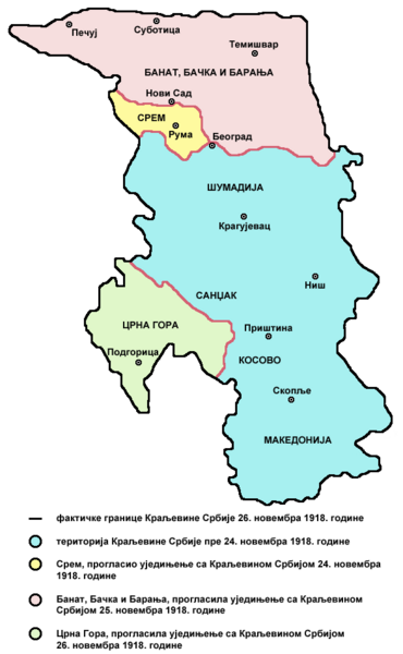
- English: de facto borders of the Kingdom of Serbia in November 26, 1918, after unification with Syrmia (November 24), Banat, Bačka and Baranja (November 25) and Montenegro (November 26) - Serbian language version
- Serbian: фактичке границе Краљевине Србије 26. новембра 1918. године, после уједињења са Сремом (24. новембра), Банатом, Бачком и Барањом (25. новембра) и Црном Гором (26. новембра) - верзија на српском језику
References
[edit].png&action=edit§ion=2)
Published references:
- Drago Njegovan, Prisajedinjenje Vojvodine Srbiji, Novi Sad, 2004.
- Drago Njegovan, Prisajedinjenje Srema, Banata, Bačke i Baranje Srbiji 1918. - dokumenti i prilozi, Novi Sad, 2001.
- Lazo M. Kostić, Srpska Vojvodina i njene manjine, Novi Sad, 1999.
- Dimitrije Boarov, Politička istorija Vojvodine, Novi Sad, 2001.
- Dr Tomislav Bogavac, Nestajanje Srba, Niš, 1994.
- Čedomir Popov - Jelena Popov, Autonomija Vojvodine - srpsko pitanje, Sremski Karlovci, 2000.
- Rade Šumonja, Spomenica oslobođenja Sombora 1918-1998, Sombor, 1998.
Internet references:
Licensing
[edit].png&action=edit§ion=3)
Self-made map by PANONIAN
| This work has been released into the public domain by its author, PANONIAN. This applies worldwide. In some countries this may not be legally possible; if so: |
File history
Click on a date/time to view the file as it appeared at that time.
| Date/Time | Thumbnail | Dimensions | User | Comment | |
|---|---|---|---|---|---|
| current | 10:01, 24 December 2009 | | 586 × 950 (56 KB) | PANONIAN (talk | contribs) | aesthetics |
| 20:47, 8 July 2009 |  | 586 × 950 (56 KB) | PANONIAN (talk | contribs) | ==Description== *'''English:''' de facto borders of the Kingdom of Serbia in November 26, 1918, after unification with Syrmia (November 24), Banat, Bačka and Baranja (November 25) and Montenegro (November 26) - Serbian language version *'''Serbian:''' ф |
You cannot overwrite this file.
File usage on Commons
There are no pages that use this file.
File usage on other wikis
The following other wikis use this file:
- Usage on lv.wikipedia.org
- Usage on ru.wikipedia.org
- Usage on sr.wikipedia.org
.png&oldid=606476858)